
WASM - The WASM Regional Center is monitoring a "severe" drought wave expected to affect wide areas of Tunisia, Algeria, and western Libya as a result of an unusual atmospheric circulation pattern that will cause a strong high-pressure system to settle over those regions. This high-pressure system extends to a wide range of southern and central Europe at intervals, leading to rising temperatures and a sharp decline in rainfall rates, which is expected to develop into the worst drought wave that these regions may experience.
Drought waves are characterized by a significant decline in rainfall rates over a long period of time, which exposes natural water reserves or water levels behind dams to sharp declines along with severe soil moisture deficiency. This causes vegetation cover to undergo sharp regression, increased fire levels, and impacts on various sectors.
Drought waves have intensified in the Maghreb region since the 2018-2019 season, due to atmospheric circulation and major climate phenomena. These areas have also begun to record severe and unusually strong heat waves compared to previous years, which has resulted in the worst forest fires in a long time, prompting the Algerian government to declare a drought wave and implement laws to cope with this difficult phenomenon.
An unusual atmospheric circulation pattern..
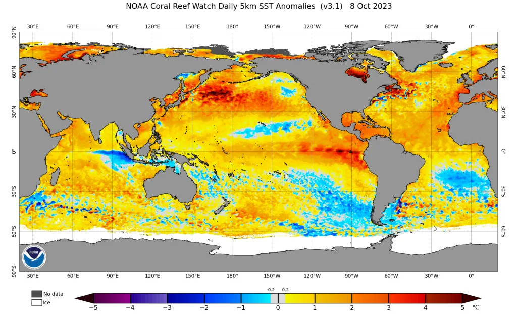
The cause of the expected severe drought wave is due to several factors, most importantly the path of the subtropical jet stream over the western Mediterranean region, which causes weak influence of strong weather conditions on those areas. It was observed that the jet stream strengthened over Algeria, Italy, and southern Germany as a result of the strength of Atlantic storms in recent periods, which derive their strength from elevated Atlantic Ocean temperatures, especially with rising temperatures of water bodies around the world for reasons that remain largely unknown, and as a result of intensifying climate change impacts.
A decline was observed in jet stream activity over the Canary Islands, Morocco, Spain, and the far southwestern part of the European continent during some periods, which contributes to the formation of low-pressure systems that work to push very hot currents from the depths of the great deserts toward the high atmospheric pressure region in southern Europe and the western Mediterranean. This causes an increase in the intensity and strength of this high-pressure system and the continuity of its effects, taking into account the expected high tropical activity in the Arabian Sea, Indian Ocean, and Somalia regions, which causes the discharge of high thermal energy over North African areas as a result of the atmospheric circulation that occurs between tropical and subtropical regions, which will further increase the intensity of this high-pressure system during the coming period.
This also causes the intensity of weather conditions and an increase in the number of low-pressure systems toward the Middle East, Arabian Peninsula, the Levant, Jordan, Egypt, and eastern Libya as a result of this unusual atmospheric circulation pattern, which is expected to intensify in the coming years.
The strong El Niño climate phenomenon..
The strong El Niño climate phenomenon is dominant, which causes unusual weather patterns in the atmosphere, reflecting the intensification of the unusual atmospheric circulation pattern. This phenomenon is expected to intensify and reach its peak strength by the end of the year and the beginning of the new year, reflecting extreme weather conditions across various countries of the world.
Despite this, these regions are expected to experience some rainy periods, but they will be short and temporary, especially during the second half of the rainy season, with the hope that they will mitigate the severity of the severe drought wave that has been affecting the western Mediterranean region for a long time and is expected to reach its peak strength in the coming months.
The WASM Regional Center, through the results of its high-precision climate model, which is the only one of its kind in the Arab region, expects the western Mediterranean region to experience temporary active periods, especially in the second and third weeks of January, and later during April 2024 and the end of spring, with expectations of temporary and moderate-intensity rainy cases in the second week of November. The region is expected to experience a very warm and dry winter with high temperatures and low humidity levels that increase evaporation, as well as large temperature differences between night and day, which increase the chances of harmful radiation frost for the agricultural sector.
While Morocco and Spain experience strong weather conditions at scattered intervals that cause flooding and severe torrents during the rainy season in general, with long and stable warm periods.