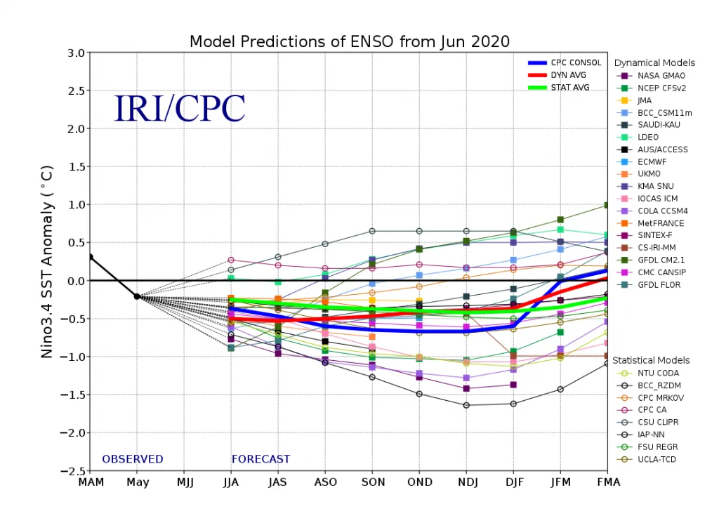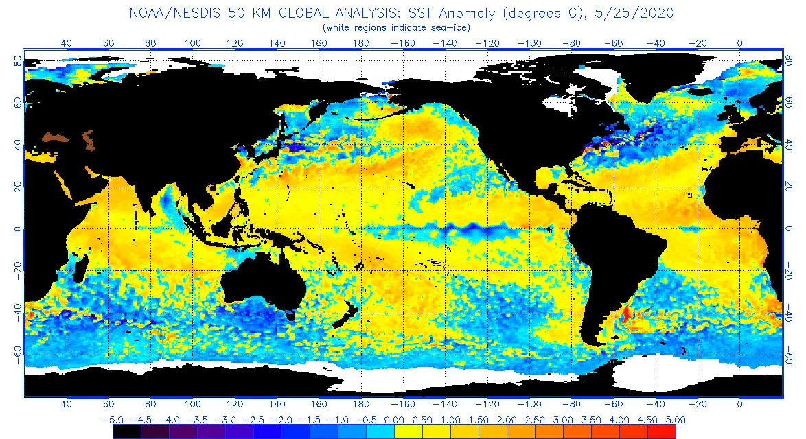
WASM – Temperatures are recording around higher than their normal rates in many areas of the tropical Pacific Ocean, especially the western parts, despite expectations of the return of the La Niña climate phenomenon, which is a decrease in temperatures in the tropical region of the Pacific Ocean. These climate phenomena cause a direct effect on the circulatory movement of the atmosphere starting from the tropical regions, and then this effect spreads to affect wide ranges of the atmosphere, and this causes floods, torrents, and drought waves in different regions of the world. It has also been observed that the El Niño phenomenon causes an increase in temperatures in a large part of the atmosphere as a result of its direct impact on the circulatory movement of air in the tropical and subtropical regions and the Hadley cell circulation.
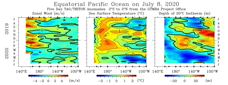
In detail, the trade winds that affect the western regions of the Pacific Ocean are still suffering from noticeable weakness and decline, and this is what prevented the clear formation of the La Niña phenomenon so far, despite the predictions of many long-range statistical and dynamic models for the return of the La Niña phenomenon with strength. However, recent forecasts indicate weakening of the La Niña phenomenon and perhaps even the non-formation of this climate phenomenon, which puts us in front of the possibility of the continuation of the El Niño phenomenon partially in parts of the western Pacific Ocean for the third consecutive year, which is a rare occurrence in general.
Despite the spread of cold water in the sub-surface layers of the tropical region of the Pacific Ocean during the previous two months, the impact is still limited on the surface layers of the water, especially with the continuation of westerly wind activity in the western tropical Pacific Ocean region, or what is called reversals, which blow against the direction of the usual trade winds movement. This is what causes Kelvin waves that are launched from the western Pacific Ocean towards its central and eastern parts, and this weakens the development of the La Niña climate phenomenon. It has also been observed that the temperature of the sub-surface waters has increased during the last two weeks in the tropical Pacific Ocean region, resulting from the Kelvin waves formed in the western Pacific Ocean.
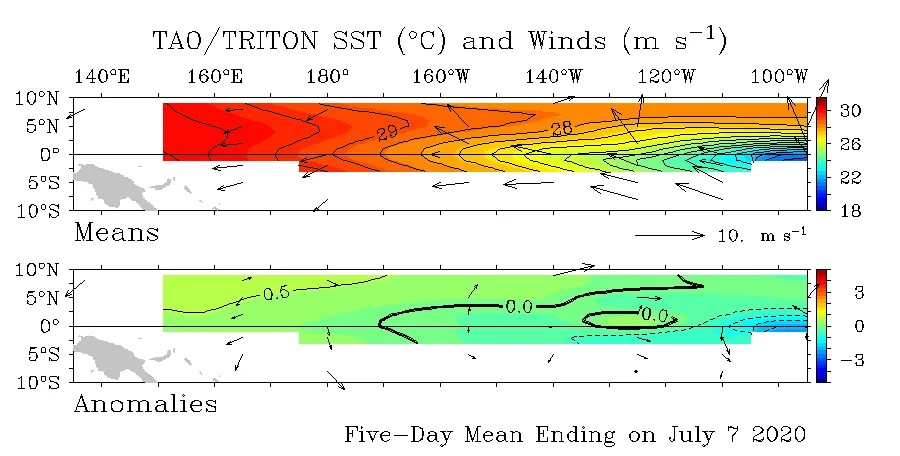
The western tropical and subtropical region of the Indian Ocean is also suffering from an increase in temperatures, as it was recording strong positive anomalies in the previous season 2019-2020, as the strong positive Indian Ocean Dipole (IOD) phenomenon causes the occurrence of a strong La Niña climate phenomenon in the following season, or the next season according to the interconnection of major climate systems (Climate teleconnection), which is caused by the movement of sub-surface and deep waters and the oscillation of trade wind movement between the Pacific and Indian Oceans, which has not happened so far. Rather, what is happening now is the opposite of what is supposed to happen, which is the retreat and weakening of the trade wind movement in the western region of the tropical Pacific Ocean.
By combining these current data, it is expected that the beginning of the next season will record weak La Niña phenomenon or equilibrium, to expect that the El Niño climate phenomenon will return with the end of fall and the beginning of winter.
This affects the intensification of rainy weather conditions better during winter and spring seasons, and the intensification of rainy conditions in parts of the Arabian Peninsula during the beginning of the rainy season, especially the eastern and southern regions of the Arabian Peninsula. Temperatures are expected to remain below normal this summer in many areas of western Arabia, the Levant, and Egypt.
Ocean heat affects the circulatory movement of the atmosphere in a clear and tangible way and causes different climate and weather phenomena, and when there is a large extreme in the temperatures of these oceans, this increases the chance of extreme weather conditions.