
WASM- The WASM Regional Center issues a detailed seasonal bulletin for the 2024-2025 season for Jordan, Palestine, and the broader Arab region. Based on data from the WASM Regional Center's climate model, which operates using calibrated statistical analogue periods with flexible methodology, a new type of statistical processing distinguished by superior accuracy exceeding the 75% threshold.
Jordan and Palestine recorded high rainfall rates over the past 10 years with increases of around 60% in some northern, eastern, and central regions of the kingdom, in an unusual manner compared to recent climate records due to recent climate changes. The recent rainy seasons have extended for long periods (meaning they start early and continue late). Winter and summer seasons have experienced a decline in duration, while transitional seasons have increased in duration. These climate changes are considered to have a positive impact on the region.
- A strong, cold rainy season, but slightly delayed|
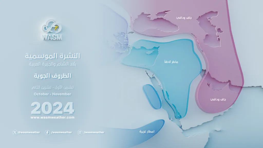
Results indicate that the rainy season will be strong and cold, especially during winter, but important rainy weather conditions are expected to be delayed slightly until the end of October. Rainy periods during autumn will be more spread out compared to normal conditions, but heavy overall, coinciding with temperatures noticeably below seasonal averages.
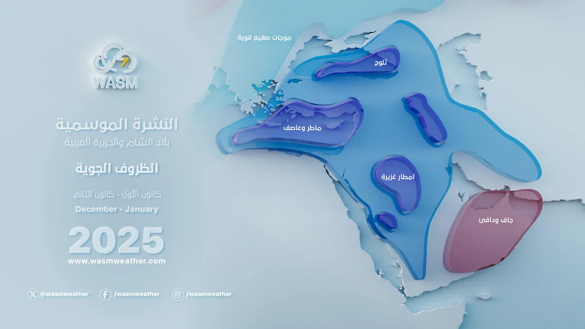
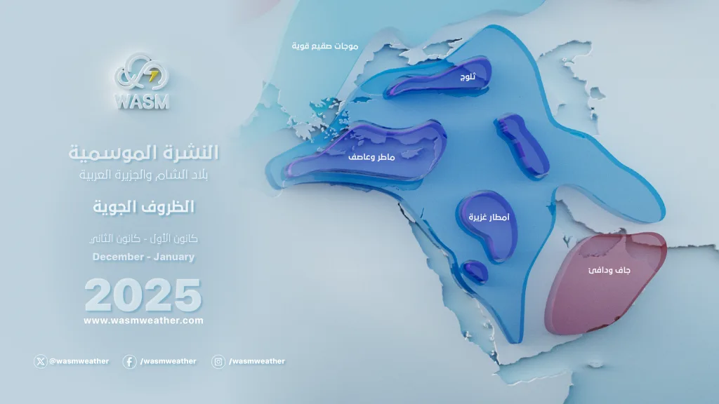
During winter, rainy conditions are expected to become more continuous and successive, with early cold waves anticipated compared to normal conditions. The chances of snowfall increase in multiple periods, especially during the second half of January 2025.
- Rainfall rates|
Large rainfall rates are expected during the rainy season in both Jordan and Palestine, especially during winter, with several heavy rainfall events anticipated in late October and early November on slightly spaced intervals during November.
Jordan and Palestine are expected to experience heavier and colder weather conditions during December and January, particularly during the first half of December and the second half of January.
Snow chances are expected to be high in multiple periods. Due to the overlap of many factors, they will be noticeably high during the second half of January and early February, with weak chances in early December.
- Temperatures|
Temperatures will remain below seasonal averages throughout most of the rainy season, especially during winter, specifically during the first half of December, as well as during the second half of January and the first half of February.
Winter is expected to be severely cold in some periods, with increased chances of "dry" frost waves during some periods of the first half of January.
Short warm periods are possible during October and November between rainy conditions, but the dominant characteristic during the autumn period will be more stable and cold at the same time.
An early cold wave during the first half of December coinciding with rainy conditions across all regions cannot be ruled out.
Weather systems|
The Red Sea low pressure system with a dry and warm extension dominates most areas of the Arabian Peninsula, Jordan, and Palestine during October. With the approach of Mediterranean lows (or Mediterranean storms) at the end of October, this is expected to increase the effectiveness of the Red Sea low, or may have a direct impact at times during the last days of October and early November.
Due to an unusual atmospheric circulation, a sharp extension of the Siberian high pressure system is expected to reach north of the Arabian Sea starting from late October. During the autumn period, with the continued extension of the Red Sea low toward western Saudi Arabia becoming more pronounced, this causes heavy rainfall conditions in late October and early November across western Arabia Peninsula, Jordan, and Palestine.

Due to the weakness of the subtropical jet stream and severely so over the Mediterranean region, matched by undulations of the polar jet stream over northwestern Europe during autumn, this causes easy flow of cold air through the middle and upper atmospheric layers toward the Arabian Peninsula and the entire Mediterranean region.
During winter, the polar jet stream axis is expected to move toward the east Atlantic, causing major bending of this current over the eastern and central Mediterranean and direct thrust of very cold air masses toward the region. With the continued weakness of the subtropical jet stream (a detailed scientific study will be dedicated to the reasons for this current's weakness), this will increase the chances of strong cold waves toward the Arabian Peninsula during winter, especially January, and early strong cold waves cannot be ruled out.
General status of major climate factors|
The Pacific Ocean is expected to experience a cold neutral state or a weak La Niña phenomenon (where the 3.4 region average is expected to reach -0.6 during October-November-December), with Pacific Ocean tropical region temperatures rising rapidly during December and January, causing unusual atmospheric circulation and major impact on the jet stream.
The tropical Atlantic region is expected to experience clear cooling during the upcoming rainy season, causing major changes to jet currents in the Mediterranean region and the rest of the atmosphere.

These major climate factors will significantly affect the circulation of the Madden-Julian Oscillation (MJO), which will take an unusual path over the tropical Pacific region and slower movement than usual in tropical African regions and parts of the Arabian Sea and Indian Ocean, causing major impact on the subtropical jet stream and significant weakening compared to normal conditions.
Weak Atlantic North storms and movement of their center axes toward the western Atlantic Ocean will result in another oscillation in the polar jet stream path and major bending over eastern Europe regions, with an expected significant weakening of its path during winter season, especially with anticipated major changes in the temperature of the northeastern Pacific region near Western American coasts.
This system and the clear changes in the atmosphere will result in unusual jet stream paths, long dry periods—either very cold or warm—in higher latitude or middle-upper latitude regions, and unusual strong and sharp Rossby waves in the atmosphere affecting especially middle-lower latitudes and subtropical regions.
WASM climate model|
The model was run in a main cycle on September 11, 2024, with collection of new data, calibration, and comparison with model results from the previous period. A major and rare match of up to 80% was found during the previous period, which increased our confidence in its results for the upcoming period.
This model operates using flexible analogue calibration of statistical similarity periods, or Analogue Calibration-Dynamic-Method, a model being developed since 2018. It produces results at 200, 500, and 700 millibar pressure levels in atmospheric layers and operates differently—not purely statistically—as purely statistical results are inaccurate and provide very random and temporally and spatially imprecise results. With the development of this model, we were able to overcome these statistical problems and even achieve precise identification of temporally active periods reaching over 90% in some periods, especially in autumn 2022, as well as autumn 2019, spring 2024, and summer 2023, when we were also able through this model to precisely determine the number of tropical storms expected to form in the Arabian Sea in autumn 2019.
The WASM Center does not recommend relying on global climate models, especially for our regions, as most Arab meteorological departments rely solely on these models, which reflects inaccurate results due to the unavailability of specialized climate models for them.
The method of issuing long-range forecasts is extremely complex, involving studying atmospheric behavior with extreme precision and understanding the weather conditions it may lead to during rainy seasons after running and calibrating the model to verify its results.
The accuracy of the WASM climate model has increased from 60% to around 75% during the recent season. With the addition of numerous developments and our ability to overcome results of statistical noise responsible for errors that may occur in long-range forecasts.