
WASM – The WASM Regional Center issues the monthly bulletin for October 2024, based on data from the WASM Regional Climate Model operated with a main cycle on 25-9, which operates using statistically analogous periods calibrated flexibly, and this model has been distinguished by superior accuracy during previous years.
General Situation|
October is expected to be slightly colder than normal with occasional short warm periods sometimes coinciding with weather disturbances. No significant or major rainy situations are expected before mid-month, with major rainy cases increasing from the 20th of the month, and a strong major rainy situation is expected during the end of the month and final days.
Rainfall will be concentrated in the western regions of the kingdom and contrary to the usual pattern, as a result of the different rotational atmosphere nature compared to previous years. Temperature is also expected to be below seasonal averages during long periods of this month, especially during night and early morning hours in an unusual manner.
An extension of the Red Sea low (which brings warmer and drier weather) is possible before mid-month in several periods and also during the end of the third week of the month. Wind speed is expected to intensify and temperatures to drop with the disturbance of the eastern Mediterranean and Turkey region, with a significant and unusual temperature drop later in early November.
Detailed Weather Conditions| ( Results from the WASM climate model and more accurate results with daily bulletins) ..
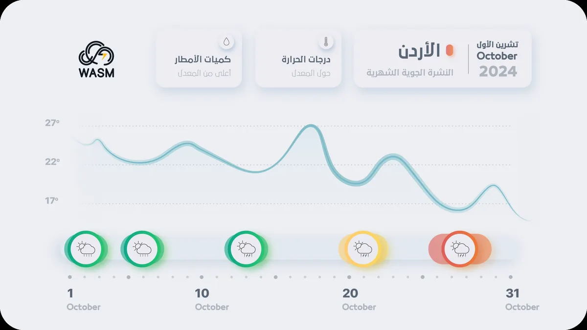
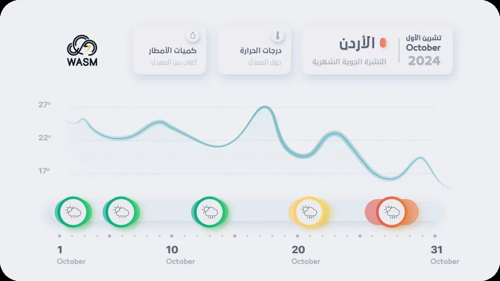
From 1 to 5 of the month.. Colder than normal conditions, with expected showers ( green level).
From 6 to 15 of the month| Extension of the Red Sea low and temperature rise followed by temperature drop and weather instability in the end of the period ( green level) .
From 16 to 19 of the month| Another dry and warm period with extension of the Red Sea low.
From 20 to 22 of the month| Weather instability and thundery showers in different areas ( yellow level) .
From 26 to 29 of the month| Heavy rainy and cold situation in parts of western kingdom ( orange level)
Levels and their meanings|
Green level.. Non-influential weather condition.
Yellow level.. Weather condition requires attention and affects some aspects of public life and usually does not pose danger.
Orange level.. Weather condition requires caution and affects many aspects of public life and poses danger in some areas.
Red level.. High-risk weather condition that requires full caution and affects most aspects of public life.
Atmospheric Circulation|
Western Europe and central Mediterranean regions are expected to witness continued strong rainy storms and cooler than normal conditions during most of the upcoming period. As a result of Mediterranean storms approaching in some periods and due to weak subtropical jet stream behavior, this causes remnants of these weather systems to rapidly reach Jordan, Palestine, and the eastern Mediterranean, causing temperature drops and rainfall showers.
Around mid-month, weather systems over the central Mediterranean are expected to become stronger and deeper, and western European storms more successive, which increases the activity of the Red Sea low toward the region, and the emergence of weather instability in some periods ( overall weak and dry) .
Toward the end of the month, atmospheric pressure is expected to rise toward central Europe and central Mediterranean clearly, pushing very cold air masses toward southeastern Europe, which will arrive as deeper cold air masses that will increase the activity of the Red Sea low that will merge with eastern Mediterranean lows, which may result in heavy and major rainy conditions in the region extending to northern and northwestern Saudi Arabia with temperatures well below seasonal averages noticeably.
The high pressure system in central Europe is expected to increase its control gradually over western Europe during November with continued unusual weakness of the jet stream.
These results are issued from our climate model at WASM, and are not final results, as daily weather forecasts will be more accurate and clearer due to the proximity of the time period.
WASM Climate Model|
The model was run with a main cycle on 25-9-2024, with collection of new data, calibration, and comparison with model results during the previous period. Results from this model remain highly accurate from 11-9 to 25-9.
This model operates using flexible calibration of statistically analogous periods, or Analogue Calibration-Dynamic-Method, and is a model being developed since 2018. It issues results at 200, 500, and 700 millibar levels in atmospheric layers, and operates in a different way that is not purely statistical, as statistical results are inaccurate and give very random results that are neither temporally nor spatially accurate. With the development of this model, we have been able to overcome these statistical problems, and we have even been able to achieve precise identification of active periods reaching over 90% in some periods, especially in the autumn season of 2022, as well as autumn 2019, spring 2024, and summer 2023, when we were also able through this model to precisely determine the number of tropical storms expected to form in the Arabian Sea in autumn 2019.
WASM Center does not recommend relying on global climate models especially for our regions, as most Arab meteorological departments depend only on these models, which reflects inaccurate results due to the lack of climate models specific to them.
The method of issuing long-range forecasts is extremely complex, as atmospheric behavior is studied with extreme precision, and knowledge of weather conditions it may lead to during rainy seasons after running and calibrating the model to verify its results.
The accuracy of the WASM climate model has increased from 60% to around 75% during the last season, and with the addition of many developments and our ability to overcome statistical noise results responsible for errors that may occur in long-range forecasts.