

WASM - WASM Regional Center is issuing the monthly bulletin for November 2024 for Jordan and, in a new development, also for countries in the Arab region through charts and illustrative maps. The center has begun operating this developed model for the capitals of Amman and Riyadh and the city of Jeddah.
WASM Regional Center uses data from its highly precise and developed climate model, which operates using calibrated flexible statistical analogue methods with significant development during the recent period, and which has uniquely monitored many weather conditions for a long time.
WASM Regional Center issued the monthly bulletin for October 2024, which forecasted a clear delay in rainfall until the end of the month, and this is indeed what is expected to occur on the ground with exceptional accuracy exceeding 80% in Jordan, Saudi Arabia, and the Arabian Peninsula.
Introduction|
This month is expected to be "much colder than usual" and rainy with heavy intensity, especially during the first half of the month as well as the last week of it, with expectations of an early cold and dry wave during mid-month.
This cold and dry wave is expected to coincide with the possibility of early frost in some high mountainous areas, exposed plains, and desert regions, especially with forecasts of its occurrence after several heavy consecutive rainy waves that reach their peak strength around November 11.
Rainfall is expected to resume later after the end of the cold and dry wave during the last week of the month and in its final days.
What will most characterize this autumn month is its unusual early and winter coldness and the large quantities of expected rainfall during many periods, especially in the western regions of the kingdom.
Details|
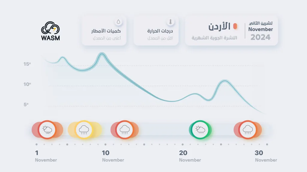
Weather conditions are expected to be distributed as follows, supported by the chart to clarify weather conditions|
From November 1 to 4: Heavy thunderstorm rainy conditions (orange level)
From November 5 to 9: Near-winter weather conditions, occasionally rainy (yellow level).
From November 11 to 14: Early winter cold weather conditions with heavy rainfall (orange level).
From November 15 to 23: Early cold and dry wave advancing from Siberia; towards the end of this period, chances of rainfall increase and temperatures rise temporarily.
From November 27 to 30: Return of winter weather conditions with heavy rainfall (orange level).
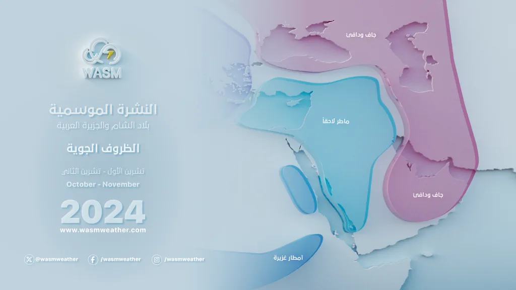
Atmospheric Circulation Pattern|
This month will witness different weather conditions from the previous month in terms of atmospheric circulation. Central and Western European regions will experience a strong atmospheric high pressure system causing weather stability and near-complete cessation of rainfall, exposing these regions to a significant risk of an unusually long dry spell.
This strong atmospheric high will cause much colder air masses relative to this time of year to be pushed towards the eastern Mediterranean region and the northern Arabian Peninsula specifically, causing continuous and successive heavy rainfall cases in the region (which will begin from the end of this month over Jordan, Levantine countries, Egypt, and Iraq). By mid-month, this atmospheric high will be positioned to the east of and across the European continent. As a result of temporary activity of Atlantic depressions and storms towards the far west of Europe, this is preceded by an unseasonable cold air mass surge towards the eastern Mediterranean, causing a heavy rainy winter condition in the Levant during the period before mid-month.
This heavy rainy winter condition will surge towards the northern Arabian Peninsula, then leading to accelerated development of the Siberian high towards Eastern Europe, northern Arabian Peninsula, and Turkey, then East Mediterranean countries, resulting in an early cold and dry wave. At the same time, this will result in a heavy and strong rainy condition in the Arabian Peninsula region.
These dry and winter cold weather conditions are expected to continue until the end of the third week of the current month, then strong activity of the atmospheric high over most European regions, particularly Western and Central Europe, is expected to resume, resulting in renewed cold and moist surges towards the region and the return of heavy rainfall.
This circulation pattern will continue during December, particularly during its first half, causing a high probability of very cold air mass surges towards the eastern Mediterranean region and northern Arabian Peninsula during that period. Monthly bulletins or reports regarding these weather conditions will be issued at a later time.
WASM Regional Center Climate Model|
The model was operated in a main cycle on 27-10-2024, with new data collection, calibration, and comparison with the model's results during the previous period. The results of this model remain extremely accurate, especially in determining the delay of rainfall until the end of October, outperforming all global climate models that failed to identify the active weather conditions during that period.
This model operates using the flexible calibrated statistical analogue method, or Analogue Calibration-Dynamic-Method, a model that has been developed since 2018 and produces results at 200, 500, and 700 millibars levels in atmospheric layers. It operates in a different and not entirely statistical manner, as statistical results are inaccurate and provide very random results with poor temporal and spatial accuracy. With the development of this model, we were able to overcome these statistical problems and achieve precise determination of active periods reaching over 90% accuracy in some periods, particularly in autumn 2022, as well as autumn 2019, spring 2024, and summer 2023, when through this model we were also able to precisely determine the expected number of tropical storms that would form in the Arabian Sea in autumn 2019.
WASM Center does not recommend relying on global climate models, particularly for our regions, due to their extremely low accuracy in the Arab region where their success is rare.
The method of issuing long-range forecasts is extremely complex, as atmospheric behavior is studied with meticulous precision and knowledge of the weather conditions it may lead to during rainy seasons after running and calibrating the model to verify its results.
The accuracy of WASM's climate model has increased from 60% to about 75% during the last season, and with the addition of many improvements and our ability to overcome statistical noise results responsible for errors that may occur in long-range forecasts.