
WASM – The WASM Regional Center issues the seasonal bulletin for the second half of the winter season based on data from the developed climate model, the only one of its kind in the Arab region, which is characterized by excellent accuracy exceeding 65%.
Overview during the first half of the rainy season|
The first half of the rainy season was characterized by abundant rainfall, which exceeded double its normal rate in northern and central regions. It is noted that some northern areas nearly achieved their entire seasonal rainfall, which is rare for this time of year, due to successive rainy weather depressions synchronized with westerly winds that were more humid and warmer than usual.
Strong storms in eastern and northern Europe pushed several rainy and humid weather depressions toward the eastern Mediterranean and Jordan during the first half of the rainy season, and this was the main reason for recording very abundant rainfall amounts, especially in northern and central parts of the kingdom.
Forecasts for the second half of the rainy season|
Rainfall amounts are expected to increase in a more comprehensive and stronger manner during the second half of the rainy season due to a change in atmospheric circulation patterns. Additionally, temperatures are expected to drop significantly and noticeably in the eastern Mediterranean and Jordan regions, and snowfall chances are expected to increase in more than one period, especially in late February and late March, with potentially very large amounts of rain and extremely cold conditions.
February month|
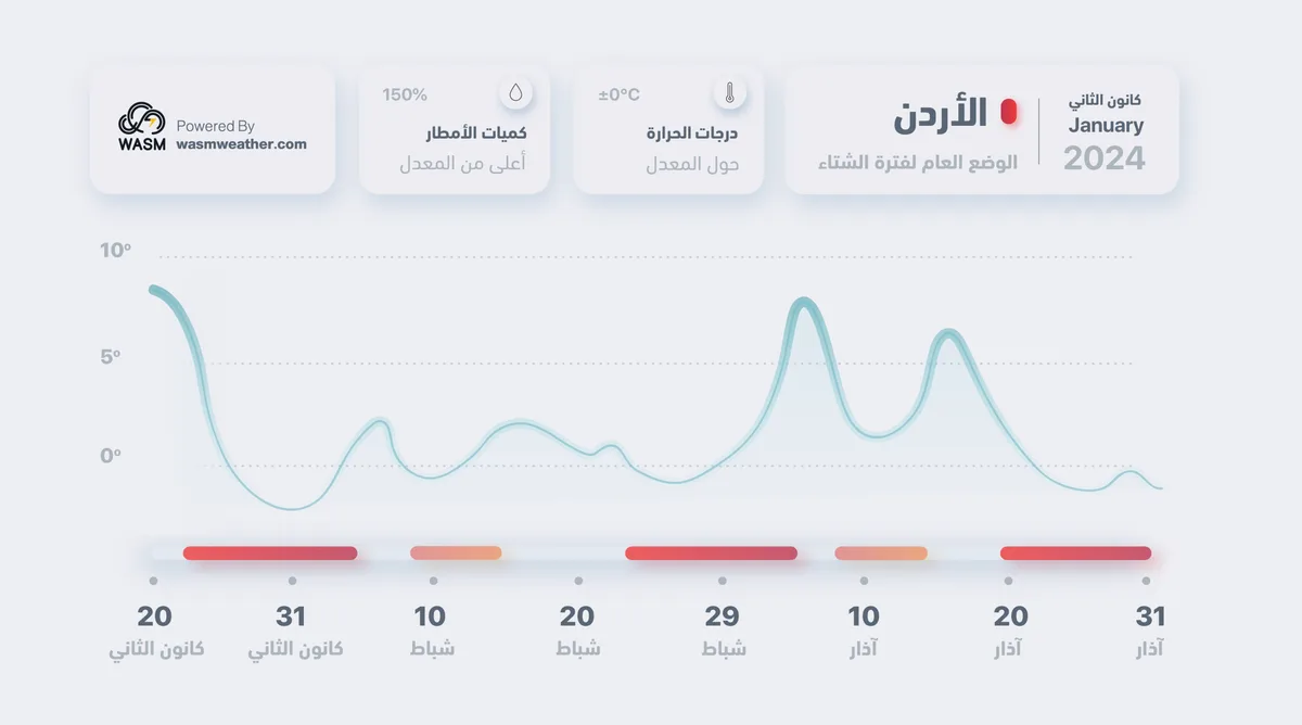
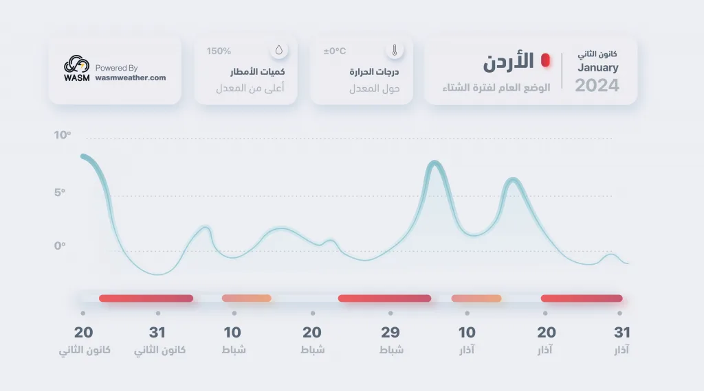
February 2024 will be characterized by high rainfall rates and temperatures below average with chances of snowfall in early month and again during the last days, with continued cold weather systems. Stable periods will average only 3-4 days between successive weather depressions (see chart).
March month|
March 2024 will be characterized by sharp weather changes during its first half and very large temperature fluctuations, which will allow for the possibility of deep rainy weather systems. However, weather conditions will change during its second half and become very cold in some periods, especially in the last days again.
According to the chart extracted from the climate model data of the WASM Regional Center, a significant temperature fluctuation is expected during the first half of March with the end of winter. However, this does not mean a decline in cold conditions or winter storms, as a strong return of them is expected in the second half of March again (where the blessed month is expected to be cold and rainy). Weather conditions at the beginning of spring are often deceptive in many years and cause major losses to the agricultural sector due to late frost waves or black frost waves.
This climate model data is long-range weather forecast data with 65% accuracy and is subject to change in some periods in terms of intensity or nature of weather conditions. Near-range weather bulletins are more accurate and detailed, but this data is important in understanding the nature and behavior of the rainy and winter season, as the WASM Regional Center has stated on more than one occasion and through Amman TV screens and local media.
Scientific Results..
The WASM Regional Center's climate model relies on small and large-scale climate oscillations and connections, their changes, behavior, and the behavior of similar periods and expected differences based on complex equations that link all these results and attempt to reduce the noise occurring in weather data. This model is capable of predicting for at least 6 months.
The El Niño climate phenomenon (the most influential on atmospheric circulation) in the Pacific Ocean region changed to become a strong non-traditional El Niño or (El Niño Modoki), coinciding with the Pacific Decadal Oscillation (PDO) which recorded extreme negative values. The synchronization of these climate phenomena with each other caused unusual climate conditions around various regions of the world, from delayed snow and warm atmospheres in many areas. This was the first time in modern climate data that these climate parameters synchronized with each other, which added additional challenges to long-range climate model outputs. This led to a very strong polar jet stream, pushing polar masses to concentrate in distant areas and coinciding with a weak subtropical jet stream, resulting in more humid conditions in the eastern Mediterranean region and parts of the Arabian Peninsula and western Europe.
The WASM climate model predicted that the polar jet stream would weaken starting from late December, but these results were delayed until January 10 due to the reasons mentioned above, as rainy and warmer-than-usual weather conditions continued for a slightly longer period than expected.
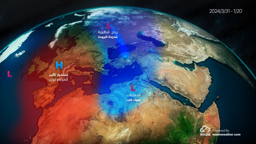
With the change in these values and their direct effect on polar circulation, a very significant weakening of the polar jet stream is expected to be noticed, coinciding with continued weakness of the subtropical jet stream, which will result in the thrust of polar air masses directly toward the eastern Mediterranean basin and northern Arabian Peninsula and colder weather conditions also in the Atlantic Ocean and central and southern United States.
These phenomena also coincided with extreme values of high temperatures in the western Indian Ocean region and the North Atlantic, which caused a clear impact on fluctuations of small and large-scale atmospheric pressure values.
Recently, there has been widespread linking of atmospheric circulation to the Stratospheric Warming (SSW) phenomenon, but there is currently no scientific evidence of its impact on atmospheric circulation. In fact, most recent scientific analyses in early January were misplaced due to lack of knowledge about the impact of this phenomenon, especially since some numerical models gave incorrect results. The impact of this phenomenon remains mysterious, and the WASM Center believes it only affects some simple details in the behavior of the atmosphere. The current atmospheric circulation has been repeating in the same manner since the beginning of the rainy season and is expected to change in the coming days.
The forecast for the extension of the rainy season results from scientific data predicting that the weakness of the polar jet stream will extend significantly for a period that may exceed 3-4 months from now. The new atmospheric behavior, which began on January 10 and will be clearer from January 22, will continue for at least 6-8 months. Europe will experience warmer and drier conditions, as will North Africa, which will allow the eastern Mediterranean, Levant, and Arabian Peninsula regions to be affected by a longer winter period than usual and an extended rainy season extending to a later period and an increased rate of strong winter storms in some periods.