
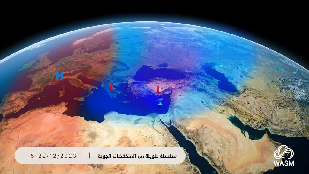
WASM- The Kingdom will be affected Tuesday evening by a low-pressure system positioned south of Cyprus, accompanied by a highly active cold frontal system, resulting in a significant temperature drop, active winds, and heavy thunderstorm rainfall across wide areas, including desert regions, causing the formation of flash floods, water accumulation, and pooling in low-lying areas.
Details..
Clouds will gradually increase tomorrow Tuesday during the day with winds becoming active ahead of the cold front passage, with thunderstorm showers falling in some parts of different areas, and gradually during the early hours of the night, the cold frontal system will affect the Kingdom with heavy thunderstorm rainfall and strong winds at times, coinciding with a significant temperature drop exceeding 10 degrees Celsius in a short period due to the strength and depth of the cold front. WASM Regional Center has issued an orange alert level for weather conditions, which is a high alert level due to the high probability of flash flood formation in many areas.
Rain showers Wednesday and Thursday morning..
The Kingdom will be affected by cold and humid westerly winds on Wednesday and Thursday with scattered rain showers falling in the north and central Kingdom sporadically, with weather stabilizing Thursday evening in anticipation of another low-pressure system forming south of Turkey.
Low-pressure system Friday and Saturday..
The Kingdom will be affected by another cold and rainy low-pressure system from Friday evening until Saturday evening, accompanied by thunderstorm and heavy rainfall at times, especially in the north and central Kingdom.
Large amounts of rainfall next week..
The Kingdom will be affected by a consecutive series of low-pressure systems starting from mid-next week, which will coincide with large amounts of rainfall and cold, humid conditions, with these low-pressure systems intensifying in coldness later after mid-month.
Scientific analysis..
This weather condition is not classified as atmospheric instability, but rather a low-pressure system located south of Cyprus accompanied by a cold frontal system of the "Kata cold-front" type. These cold fronts are characterized by sharp temperature gradients along a nearly parallel vertical line across all atmospheric layers at a specific point, as well as a very sharp horizontal thermal gradient. Their position is usually in front of the active jet stream and perpendicular to latitude lines, which increases their effectiveness and quality. This cold front coincides with the advancement of warm, humid, and sub-tropical winds ahead of it, causing sometimes strong thunderstorms during its passage. Precipitation from these fronts is characterized by very high intensity rates at times and in some areas, increasing the chances of flood and flash flood formation, while atmospheric instability cases are characterized by limitation rather than comprehensiveness.
With the anticipated development of a strong high-pressure zone during the second week of the month, coinciding at the same time with the continuation of consecutive low-pressure systems affecting the Kingdom, colder and more polar air masses will gradually approach the Kingdom from the north and east of Europe, positioning themselves around eastern and southeastern Europe later after mid-current month. This usually causes large amounts of rainfall during this distinctive atmospheric arrangement for the region.
WASM Regional Center is monitoring the expected weather conditions during the coming period, which are expected to be characterized by large rainfall rates, high intensity rates, acute atmospheric disturbances, and variation in rainy weather conditions in terms of type and intensity.
The North Pole is experiencing very sharp oscillations during the current period, allowing the advancement of extremely cold polar winds toward mid-latitudes, causing strong atmospheric disturbances in many areas, especially eastern Europe and its southeast, as well as parts of its north, and the eastern Mediterranean region.
.