
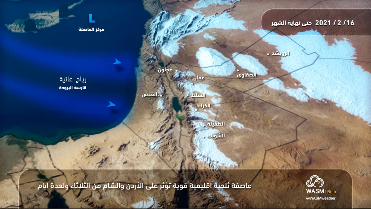
WASM- Jordan is being affected by a snowstorm that begins hours during the night of Tuesday/Wednesday and intensifies on Wednesday, continuing until Friday morning, causing strong winds and heavy rainfall in low-lying areas, flash floods, and heavy accumulating snow above elevations of 800 meters, dropping to 600 meters in the evening of Wednesday during the peak of the snowstorm. WASM has issued the red alert level, which is the highest level, due to the snowstorm.
In detail, an extremely cold polar air mass is being driven into the kingdom directly from northern Siberia toward the eastern Mediterranean, Jordan, and countries in the region, causing the formation of a very deep atmospheric low pressure system positioned over eastern Cyprus and northern Syria, which causes dusty winds to stir up dense dust in various areas of the kingdom during Tuesday daytime. As Tuesday evening hours approach, the polar cold atmospheric front advances, resulting in a significant temperature drop of around 10-15 degrees Celsius within a few hours, causing heavy rainfall, thunderstorms, and hail. During nighttime hours, snow begins to fall above elevations of 1,000 meters, gradually decreasing during Wednesday dawn and morning to 800 meters, with these snow accumulations being heavy and sometimes falling below this elevation.
During Wednesday afternoon, precipitation "eases" and strong winds intensify due to the formation of another new and deep low pressure system accompanied by an even colder and deeper cold front (extending into the upper atmospheric layers) coming from northern Siberian lands, leading to a renewal of heavy precipitation in all areas during Wednesday afternoon and evening. The heavy accumulating snowfall level also drops to 600 meters on Wednesday/Thursday night, with the snowstorm affecting all regions of the kingdom, including the south. Snow accumulates densely in high mountains, including the mountains of the capital Amman, and snow affects many major cities in the kingdom. Snow is expected to fall below 600 meters without significant accumulations, with precipitation levels reaching around 500 meters.
The snowstorm begins to gradually retreat during Thursday, with the snowfall level beginning to rise back to 800 meters, then reaching 900 meters with midday hours, and with Thursday nighttime hours reaching around 1,000 meters or near this elevation intermittently with the formation of dense fog in the mountains. Intermittent snow showers mixed sometimes with rain showers will continue on high mountains above 1,000 meters until Friday/Saturday night.
Caution must be exercised regarding the strength of winds, with gusts during the storm exceeding 100 km/hour, which poses a danger to electrical and agricultural sectors in the kingdom, and from flash floods during the weather condition and also during snow melting on Friday in the mountains, especially with the expectation that snow showers will mix with rain, which will accelerate the melting rate.
This snowstorm is part of a long-duration polar wave expected to continue affecting Jordan until the end of February and the beginning of March. WASM will issue all reports consecutively during the weather condition.
This snowstorm has affected wide areas of Turkey and the city of Istanbul, causing significant accumulations, and the impact of this storm is expected to reach all areas of the Levant, Iraq, and weakly northern Saudi Arabia, making it a rare regional snowstorm impact.
.
To know the temperatures in your cities, please
visit the following link.. www.wasmweather.com