

WASM- The WASM Regional Center issues the seasonal bulletin for the 2025-2026 season using data from the center's climate model designated for long-range forecasts, which is distinguished by greater accuracy in the Arab region and operated as of 2-10-2025.
General Situation|
Data issued indicates a normal to modest beginning in Jordan, Palestine, the Arabian Peninsula, the Arab Gulf states, Kuwait and northern Egypt, but with heavy rainfall cases in Syria, Lebanon, Tunisia, Libya and eastern Algeria.
Weather conditions intensify gradually in the Arabian Peninsula and the Levant throughout mid and late autumn and intensify during winter and the second half of the rainy season.
Temperatures below seasonal averages across most of the region due to the dominance of a strong high-pressure system over the European continent for most days of the upcoming rainy season.
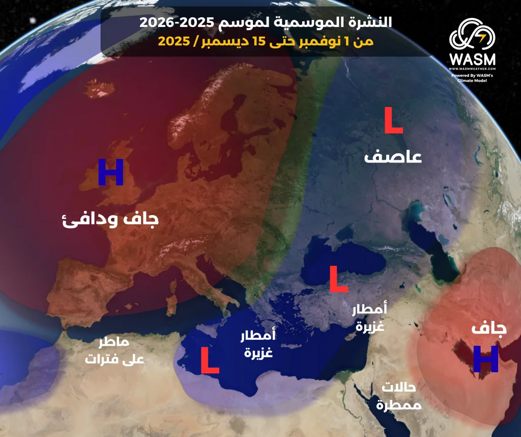
Period between November 1 and December 15|
Atmospheric depressions and rainfall cases concentrate in the central Mediterranean region and heavily impact those areas, with these atmospheric depressions' effects extending to Syria and Lebanon.
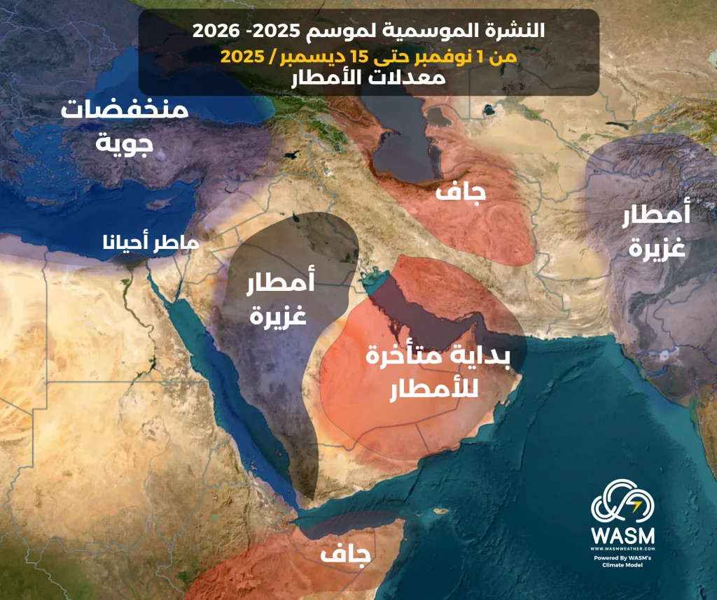
Beginning from the end of October and start of November (beginning of this period), weather becomes unstable in northern and western Saudi Arabia and sometimes in Jordan and Palestine, leading to rainfall cases with possible heavy intensity in certain periods, while dryness and warmth continue in the central and eastern regions of Saudi Arabia and most Arab Gulf states.
With the mid-point of this period, autumn weather conditions intensify in the Red Sea region, western and northern Saudi Arabia and its northwestern areas, Kuwait, southern and central Iraq, Jordan, Palestine and northern Egypt, while cold and early atmospheric depressions continue to affect the central Mediterranean and the Levant, particularly Syria and Lebanon.
Towards the end of this period, rainfall cases begin to become more widespread and gradually affecting the region, while strong weather conditions begin to gradually retreat in the central Mediterranean and concentrate toward the eastern Mediterranean.
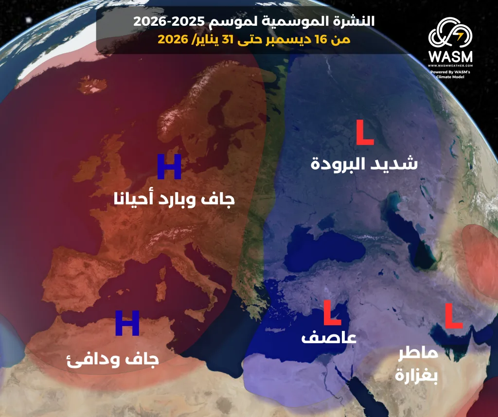
Period between December 16 and January 31|
The intensity of weather conditions in the central Mediterranean weakens with the dominance of a strong high-pressure system over the European continent and North Africa, which exposes these areas to clear periods of rainfall interruption.
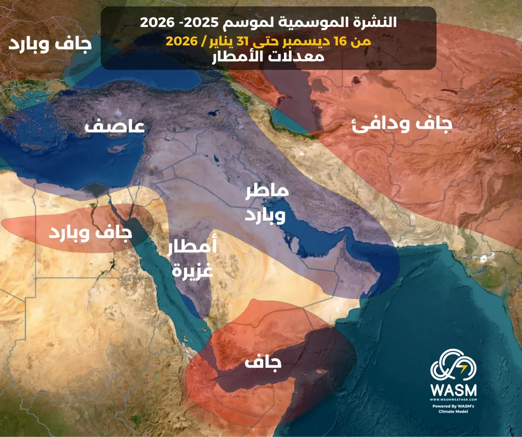
This leads to the concentration of the Mediterranean front and atmospheric depressions toward the eastern Mediterranean, Turkey and the Arabian Peninsula, resulting in heavy rainfall and colder weather conditions during this period.
The intensity or peak of weather conditions is evident in the eastern Mediterranean during the mid and late stages of this period, and rainfall in the Arabian Peninsula and Iraq region will be more widespread than usual.
Temperatures are cold during this period to very cold towards the end of it with expectations of clear polar wave activity, especially in the second half of January toward the eastern Mediterranean.
Atmospheric Circulation|
A strong high-pressure system is expected to dominate most areas of Europe during the upcoming rainy season, particularly the western parts in the first place, the British Isles and Scandinavia.
This leads to a clear weakening of the subtropical jet stream in the Mediterranean region, and due to climatic weather conditions and the continued dominance of the high-pressure system over the European continent, the polar jet stream is expected to weaken significantly (for the first time since 2022), leading to significant activity in polar waves toward the Mediterranean and the northern hemisphere.
Global climatic conditions indicate the continuation of the negative neutral phase's dominance during autumn over the tropical Pacific Ocean with a low chance of developing a temporary weak La Niña phenomenon during autumn, followed by an accelerating temperature rise in the central and western tropical regions of the Pacific Ocean and a gradual beginning of "Modoki El Niño" development during winter and spring, which is considered the most dangerous climatic phenomenon due to the extreme global climatic conditions it causes.
This coincides with a gradual cooling of the northern Pacific Ocean leading to a historical change in the negative POD factor to a neutral or positive phase quickly, reflecting a severe response to atmospheric circulation.
Summary|
- A strong beginning to the rainy season in the central Mediterranean region, Tunisia, eastern Algeria, northern Libya and gradually northern Egypt, Syria and Lebanon.
- Heavy rainfall cases begin gradually in western and northern Saudi Arabia, southern and central Iraq, and Kuwait from the end of October and continue throughout the rainy season at intervals.
- Rainfall cases intensify gradually in Jordan and Palestine during autumn and become strong and cold during winter.
- The rainy season weakens noticeably over the central Mediterranean and the Arab Maghreb during winter.
- Rainfall cases cover wide areas of the Arabian Peninsula and extend toward Arab Gulf states, the Emirates and Oman during winter.
This is a long-range weather bulletin and does not replace daily, regional, weekly and monthly weather bulletins, which are more accurate and detailed in comparison with this bulletin.