

WASM – The Pacific Ocean continues to experience a period of calm and equilibrium "the absence of the influence of a major climate phenomenon" since the previous rainy season, following the El Niño phenomenon that occurred in the 2023-2024 season, which brought heavy rainfall to most of the Middle East region. Areas of Jordan, Palestine, and vast regions of Saudi Arabia achieved more than 150% of the entire rainy season, and more than 400% in the UAE and parts of the Arabian Gulf region, as El Niño phenomena increase positive weather systems for better rainy seasons in the Middle East.
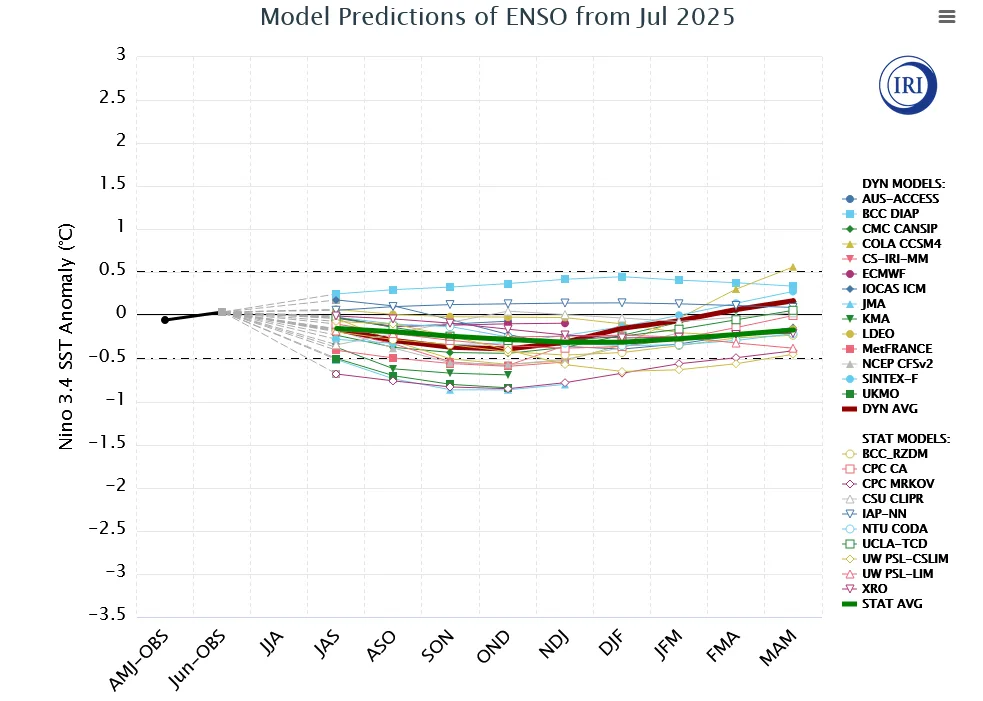
With the dormancy of the tropical Pacific region during the recent 2024-2025 season without the influence of any major climate phenomenon, this dormancy is expected to continue until autumn 2025, but there are important changes that may occur with the second half of the next rainy season, which could lead to severe weather conditions in various regions of the world, particularly in the Mediterranean and Middle East regions, North America, and East Asia.
The Current Situation of the Pacific Ocean |
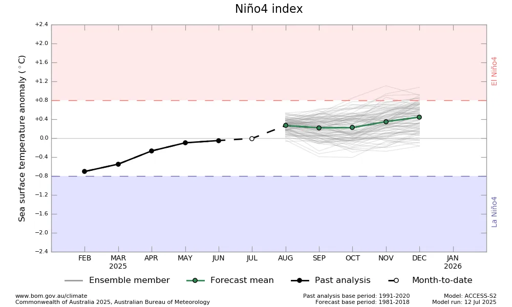
Before delving into the expected climate conditions during the upcoming season, the tropical Pacific Ocean remains dormant without any dominant major climate phenomenon since the end of summer 2024. The La Niña phenomenon has failed to develop, which matches our center's studies during the previous summer, and temperatures in the tropical region of the Pacific Ocean remain around normal seasonal rates, reflecting no significant influence from the tropical Pacific Ocean on atmospheric circulation.
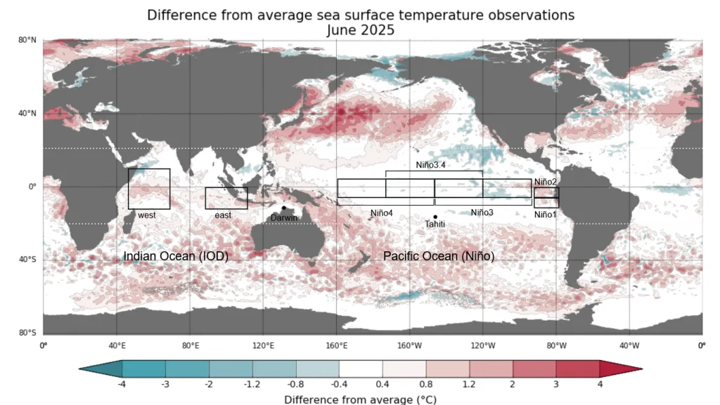
The northern Pacific region is experiencing unusually high temperatures, and according to WASM Regional Center's observations and recent studies and the center's climate model data, this has greatly affected polar circulation around the northern hemisphere and the significant impact on the polar jet stream to become strong, especially over the Pacific Ocean and also over northern Europe in general. This coincided directly with a significant weakening of the subtropical jet stream, which affected the movement of Mediterranean low-pressure systems, causing their centers to shift toward south of Cyprus and northern Egypt, leading to decreased rainfall rates in the northwestern part of the country and increased rainfall rates clearly in central, eastern, and southern Jordan and western, northern, and western Saudi Arabia during the previous season.
These conditions will change slightly with the expected shift of northern Pacific heat toward the coasts of Canada and western America with the upcoming season, as well as "a clear rise" in the temperature of the western tropical Pacific region, which greatly increases the likelihood of developing a "western El Niño" or Modoki El Niño phenomenon responsible directly for extremes in atmospheric circulation, which may cause a clear impact on the nature of the polar jet stream in the Pacific Ocean and North America regions, where it will greatly increase the chances of strong storms over central and western North America and the south.
The Expected Situation of the Pacific Ocean During Autumn |
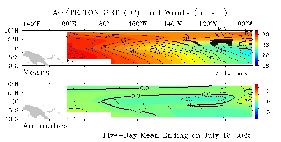
The continuation of the equilibrium phase "dormancy" in the tropical Pacific region is expected, with continued high temperatures also in the eastern tropical Indian Ocean region (i.e., between 160 east and up to 100 east in the tropical band), the equilibrium phase of the tropical Pacific region, leading to weakening of its significant impact on atmospheric circulation, with continued negativity of Indian Ocean circulation – IOD-.
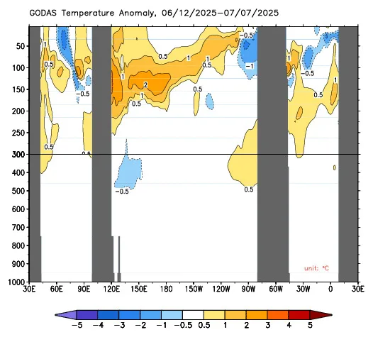
However, due to the large presence of warm waters in the subsurface region along the western part of the tropical Pacific Ocean, and a continuous disruption in trade wind movement, warm waters are expected to extend more than usual to 140 west from the tropical Pacific region, which will include the Niño 4.0 region, gradually leading to the development of a Modoki El Niño phenomenon during the second half of the next rainy season. This reflects a very strong impact on the nature of the rainy season in the region and may be more dangerous than usual. The beginning of the next season may not be very promising, but all of this will change gradually.
Modoki El Niño Phenomena |
Modoki El Niño phenomena are more complex to atmospheric circulation, but according to studies we have conducted at WASM Regional Center, mild phenomena of these give more clear results about the nature of rainy seasons compared with stronger phenomena. Fortunately, we do not expect a strong Modoki El Niño phenomenon during the next season, which will facilitate the work of our climate model to provide results closer to reality, especially regarding the nature and characteristics of the season regarding rainfall.
Important Changes During the Second Half of the Next Season |
This change is expected to begin clearly from the eastern Indian Ocean region, with the beginning of a gradual decrease in temperatures in those areas during the autumn season and weakening or disruption of trade winds in the western and central Pacific Ocean regions, and the continuation of cold water flow along the coasts of Peru to the eastern part of the Pacific Ocean and also from the depths. This greatly promotes the emergence of hot spots in the 4.0 region of the tropical Pacific Ocean.
This leads to an unusual tropical cell in the tropical region between the Pacific and Indian Oceans, where air rising increases in the western and central Indian Ocean regions, leading to the Modoki El Niño phenomenon in the tropical Pacific Ocean region and significant weather activity near the regions of Yemen, western and northern Saudi Arabia, Egypt, and the eastern Mediterranean.
The study of the impacts of weakening the jet stream in the Mediterranean will lead to the continuity of cold wind flow through the upper atmosphere layers toward the eastern Mediterranean and the continuation of very active weather conditions in those regions. With the impact of the Modoki El Niño phenomenon on the nature of weather conditions over the northern Pacific Ocean, this may lead to major undulations or sharp weakening of the polar jet stream near the southeastern Europe regions during the second half of the next rainy season and increased chances of wet cold waves that will also affect the Balkans, Turkey, Egypt, and the eastern Mediterranean, and the return of Cyprus low-pressure systems to their usual path (i.e., around or near the island of Cyprus).
Weak rainy season will continue in the first half of the next rainy season over the UAE and Oman as a result of tropical circulation in the Indian and Pacific Ocean regions, but this will gradually change and increase the chances of strong rainy cases over central Saudi Arabia and areas south of the Arabian Gulf.
Modoki El Niño phenomena are complex, but their impact on atmospheric circulation is "severe and extreme," and strong and snowy seasons were associated with these phenomena affecting the eastern Mediterranean, the Levant, and the Arabian Peninsula.
Forecasts for the Remainder of Summer 2025 |
Moderate weather or below-average temperatures continue in the eastern Mediterranean, the Levant, Jordan, and northern Saudi Arabia and its western and central parts in an unusual manner, and brief hot periods are not ruled out at times.
And heavy rainfall rates in southwestern Saudi Arabia, Yemen, Sudan, and even southern Egypt as well as the Sahara Desert regions. The current summer season is expected to end early and with the end of August in the eastern Mediterranean and the Levant regions and the beginning of moderate autumn effects.