

WASM- La Niña and El Niño climatic phenomena are considered the most important climate factors in atmospheric circulation cycling, which directly affect the activity of the jet stream, especially the subtropical one, leading to specific weather patterns and different atmospheric circulation cycles.
The failure of the La Niña climatic phenomenon to develop this season, which is considered the most important climatic phenomenon and the main factor affecting atmospheric circulation, and despite the insistence of American climate models on predicting its formation, the results during the first week of November show its rapid and continuous deterioration before it forms. Region 3.4 did not record values lower than -0.5°C, and the last recorded value was -0.2°C. We need values lower than -0.7°C for several consecutive readings and an official announcement from the Australian Bureau of Meteorology.
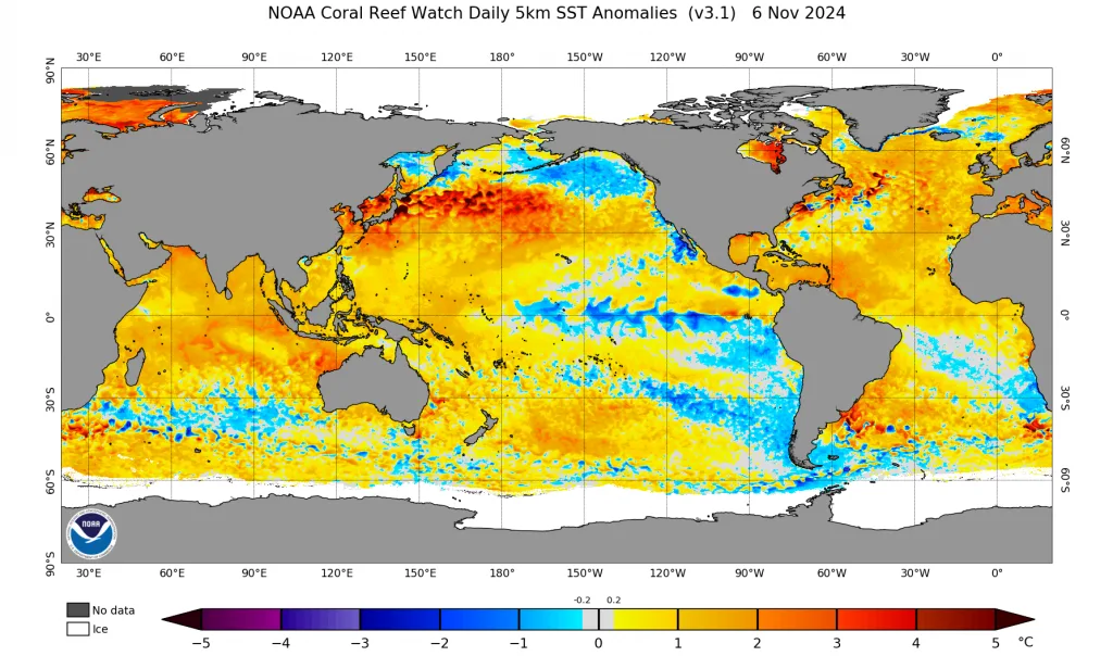
The reason for the failure of La Niña climatic phenomenon to develop goes back to many interconnected factors, most importantly the decline of cold water presence in semi-deep waters along the equator of the Pacific Ocean, especially the western part, and a significant weakening in trade wind speeds that did not exceed the minimum value required for the development of this phenomenon.
The recent strong rainy conditions in the region have no direct relationship with these phenomena, but rather will cause unusual circulation of the atmosphere, and increase the chances of more extreme and stronger rainy conditions in the region.
WASM Regional Center announced since summer predictions of the failure of this climatic phenomenon to develop, for many scientific reasons, which we will explain again.
Significant Weakening of Trade Wind Speeds|
The significant weakening of trade wind speeds, which are considered the most important factor in promoting the La Niña climatic phenomenon, has caused the failure of this phenomenon to develop before it even begins. The reason for this is the continued oscillation of atmospheric pressure in the tropical Pacific Ocean region and the failure of the tropical Pacific Ocean region to cool as required.
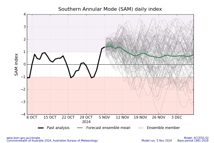
Sharp Negative Oscillation in the Southern Annular Mode (SAM) Index|
The southern polar oscillation index continues to record sharp negative values since summer, which greatly affects the movement of trade winds in the subtropical and tropical regions of the Pacific Ocean. We believe that this oscillation is the biggest reason for the weakening of trade wind speeds.
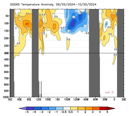
Significant Decline in Semi-Deep Cold Waters|
Semi-deep cold waters concentrated in the eastern region of the tropical Pacific Ocean, and this is what we observe from the concentration of cold in those areas for some time.
What are the Impacts?
This contributes to a different circulation of the atmosphere compared to the predictions of global climate models, which indicated cold weather conditions and high precipitation amounts in the European continent, but what is happening now is the opposite, as we observe the dominance of a strong high-pressure zone over most of Europe which is expected to continue for several more long weeks!.
The failure of this phenomenon to develop, in addition to a sudden weakening of the subtropical jet stream, especially in the Atlantic Ocean region, and the concentration of cold waters only in the eastern part of the tropical Pacific Ocean and also the tropical and subtropical Atlantic Ocean region, have caused strange behavior of the subtropical jet stream and sharp weakening especially in the Mediterranean region, resulting in strong and severe rainy conditions in the Mediterranean region.
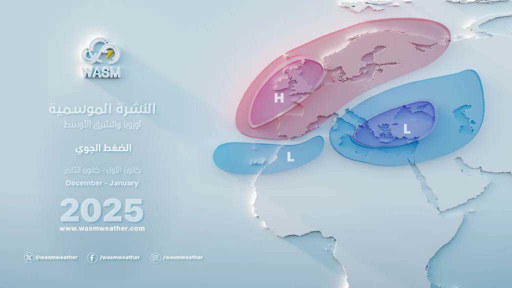
WASM Regional Center was unique in these long-range weather forecasts which focused on the extremity of weather conditions in the Mediterranean during the current rainy season as a result of the weakening of the subtropical jet stream.
What is also most important is the accumulation of warmer-than-usual waters in the northern Pacific Ocean in recent periods, which caused a distinctive behavior of the polar jet stream, and for many other interconnected reasons, this caused a large and sharp undulation of the polar jet stream, causing severe rainy conditions in subtropical and mid-latitudes during recent weeks that included most of the Arab region.
Due to the continuation of this strange behavior, WASM Regional Center expects early and unusual cold waves during the coming weeks, including a sharp cold wave in mid-November and beyond, which will result in more strong rainy conditions in wide areas of the Arabian Peninsula and the Mediterranean.
We monitor the renewal of heavy rainy conditions in Saudi Arabia and the Arab Gulf countries, Iraq, the Levant and Jordan, as well as a wide range of Maghreb countries, Spain, and starting from mid-month, with the continuation of a long and unusual drought wave over the European continent, and its renewal on the eastern coast of America.
The high atmospheric pressure zone will be more concentrated towards central and western Europe starting from before mid-November, which will stimulate the surge of strong cold sedimentary waves towards eastern Europe and the Mediterranean region, especially its eastern part.
Many areas are exposed to heavy rainy waves, most importantly in the western Mediterranean region, as well as the Levant countries and Jordan, as well as the Arabian Peninsula region, specifically the Red Sea coasts, central and eastern Saudi Arabia, the Arab Gulf region, Kuwait, and Iraq.
This will cause strong snow storms expected in eastern Europe, the Black Sea region, and Turkey during the coming weeks, due to the strange behavior of the jet stream.
https://www.ospo.noaa.gov/products/ocean/sst/anomaly/
https://www.pmel.noaa.gov/elnino/status
http://www.bom.gov.au/climate/enso/#tabs=Overview
Photo: Joseph Barrientos, Unsplash