
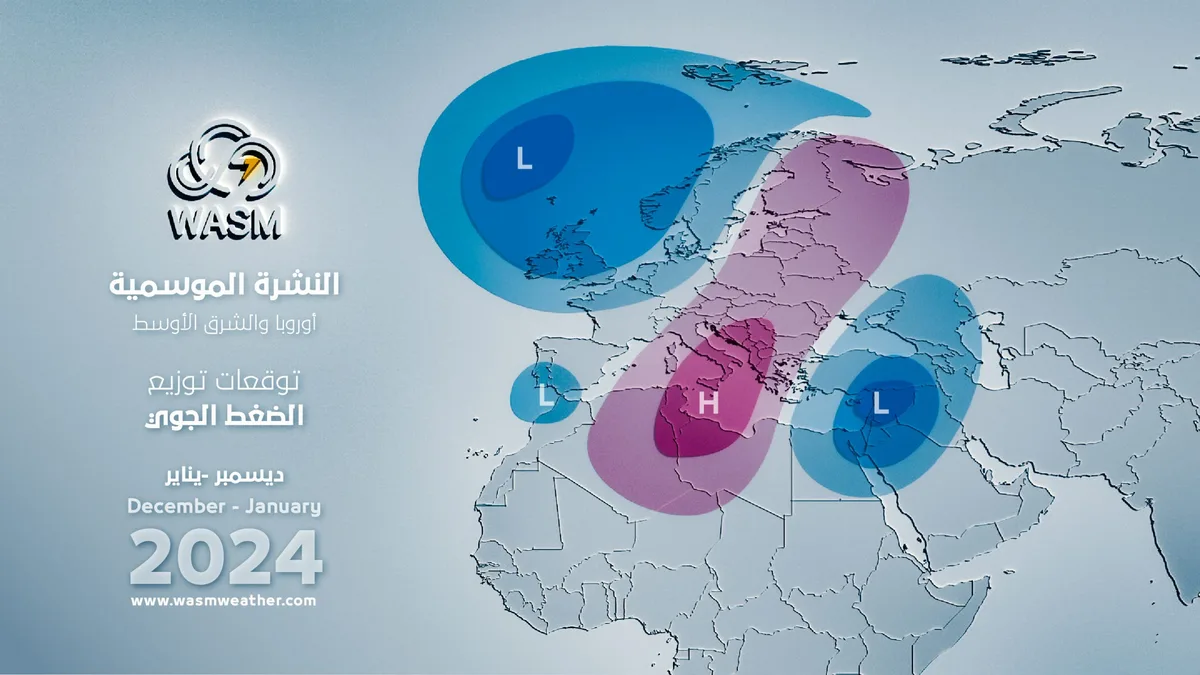
WASM- The WASM Regional Center issues the seasonal bulletin using climate model data from the WASM Regional Center, which relies on calibrated statistical methods. The climate model accuracy reaches 68%. The WASM climate model was able to forecast the strength of the previous rainy season in the region, which is considered the only model that was able to detect these results due to the advanced methodology it operates with.
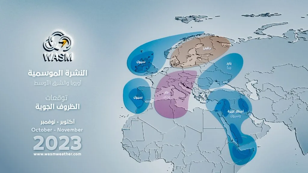
With the model running for the current season, important expected results were detected, particularly those related to the cooler season compared to previous years, with predictions of temperatures below seasonal averages by several degrees in northern Arabian Peninsula, Jordan, Saudi Arabia, Iraq, and Egypt coinciding with expectations of strong weather conditions.
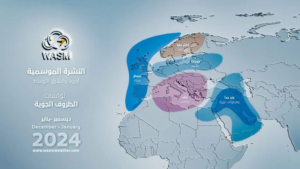
The region is expected to experience a strong and heavily rainy fall, particularly Jordan, Palestine, the Levant, northeastern Egypt, and northern and western Saudi Arabia, followed by an extremely cold winter compared to previous years with heavy rainfall conditions.
Scientific details regarding expected climate conditions in various regions of the world and the method of impact of important climate factors on atmospheric oscillations will be mentioned.
Jordan|
Jordan is expected to experience a cold and heavily rainy season, particularly during the fall and winter seasons with temperatures below seasonal averages by several degrees compared to previous years. The expected season is predicted to be characterized by consecutive rainy and cold conditions separated by short and slightly warm stable periods.
- Fall Period (October and November) 2023..
Jordan is expected to experience a cold and heavily rainy fall, particularly between mid-October and mid-November, with very cold winter conditions beginning early at the end of November. Stable and warm periods are expected to be few and scattered compared to previous years.
Heavy rainfall is expected particularly at the end of October and beginning of November, as well as at the end of November, with increased chances of floods during these periods amid low temperatures compared to seasonal averages by several degrees.
Rainfall.. above average.
Temperature.. below average.
- Winter Period (December and January) 2023-2024..
The region will experience very cold weather conditions and temperatures clearly below seasonal averages, with consecutive heavy rainfall conditions. Very cold weather conditions are expected to increase during the second half of December and early January, as well as the last 10 days of January.
Expected rainfall amounts during this period will be large, particularly in the northern and central regions of Jordan, especially during December.
Rainfall.. much above average.
Temperature.. sharply below average.
- Rest of the rainy season..
Despite the distance of this period, climate model results indicate strong weather conditions but more scattered compared to the first half of the rainy season. Nevertheless, chances of extreme weather conditions are expected to increase again, particularly during February and March.
Saudi Arabia and Arabian Gulf States..
Saudi Arabia is expected to be affected by a strong rainy season with chances of extremely weather conditions in multiple periods during the rainy season, particularly during the WASM and fall periods.
Heavy rainy fall conditions concentrate in northern and western Saudi Arabia during October-November, gradually moving toward central and eastern Saudi Arabia during December-January and continuing at scattered intervals in northern and western Saudi Arabia.
Northern Saudi Arabia is expected to experience severe cold waves during December and January, with greatly increased chances of snowfall in northern areas, particularly at the beginning of January coinciding with several strong frost waves.
The Red Sea region is expected to experience extremely rainy conditions during November with large amounts of rainfall expected to cause flash floods.
Kuwait is expected to experience a long and heavily rainy season, with continuous consecutive waves of heavy rainfall throughout the rainy season and below-average temperatures with strong cold waves during January.
The UAE, Oman, Qatar, and Bahrain will experience a dry beginning of the rainy season and warmer, with rainy conditions gradually beginning during the second half of December and intensifying during January, particularly mid-January, where southeastern Arabian Peninsula areas are expected to experience an important and significant weather system.
Iraq is expected to experience a strong rainy season particularly in the eastern, northern, southeastern and central parts of Iraq, specifically during the fall period with extremely cold waves and strong frost waves expected during January.
Rainfall.. much above average concentrated in northern and western Saudi Arabia and its northeast.
Temperature.. below average in northern Saudi Arabia and above average in its southeast, Oman, and the UAE.
Dust storms.. below average.
Rest of the rainy season..
Northern and western Saudi Arabia will experience a temporary decline in seasonal performance during February with conditions continuing in southern and eastern Arabian Peninsula, and rainy conditions will intensify strongly and with heavy precipitation during the spring period through early summer.
Algeria, Tunisia, and Morocco..
Algeria and Tunisia are expected to experience a severe drought during the upcoming rainy season with a significant decrease in rainfall rates. The region is expected to experience scattered rainy conditions and seasonally high temperatures, with weather conditions concentrated around mid-November, as well as during mid-January which may be in the form of a severe cold wave accompanied by rainfall and snowfall.
The rainy season performance is expected to improve later during the spring but without expectation of improving the seasonal rainfall average. The drought wave is expected to be the worst in many years.
Morocco will experience large amounts of rainfall in the form of strong weather systems scattered and separated by long, warm stable periods, with high chances of floods and flash floods during the rainy season.
Atmosphere and Scientific Data..
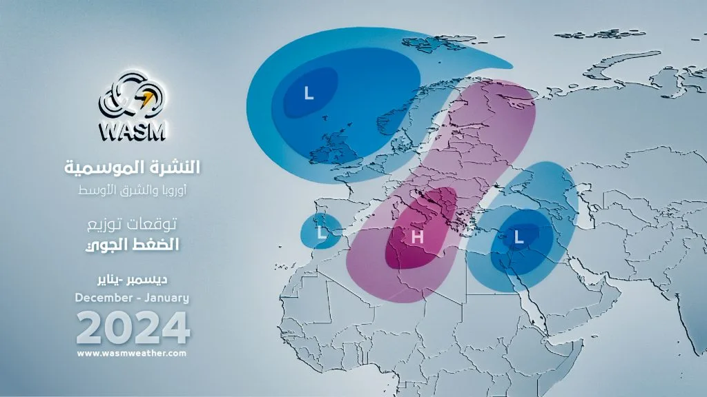
A strong atmospheric high is expected to affect central Europe as shown in maps issued from WASM Regional Center climate model data, extending from North Africa, which brings long dry periods, warm in southern Europe with expectations of strong and scattered frost waves on parts of central Europe more clearly visible in eastern Europe.
The strong atmospheric high works to push very cold air masses toward the eastern Mediterranean region and northern Arabian Peninsula. This high will shift its axis slightly toward Russia and northeastern Europe during winter, pushing even colder air masses from central Siberia or from northern Europe regions depending on its activity axis and positioning method, which depend on Atlantic Ocean storm activity.
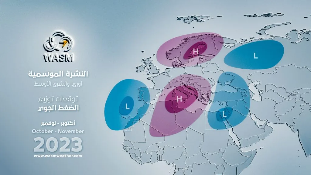
A strong atmospheric high is also expected to be centered over Canada and northern United States, which activates Atlantic Ocean storms supported by much elevated North Atlantic heat.
Due to the weakening of the subtropical jet stream over southwestern Europe due to the nature of Canadian high activity, this causes strong weather conditions to form over Spain and Morocco at scattered intervals, particularly with the reformation of the Canadian high during successive atmospheric cycles.
The British Isles will be exposed to Atlantic Ocean storms which will become more consecutive during January, particularly mid-January, causing strong frost waves in some periods after the end of Atlantic activity over central and southern Europe.
The manner of activity of the warm atmospheric high in the European continent will be longer than usual with 2 to 3 consecutive and strong cycles particularly during December and early January, as well as late January and during February, increasing chances of strong polar waves toward the eastern Mediterranean, eastern Turkey, and northern Arabian Peninsula in winter.
A pronounced and unusually severe weakening of the subtropical jet stream was observed, even to central and southern Egypt sometimes, causing cold air masses to reach a wide range of the eastern Mediterranean, and occurrence of a humid cycle resulting from succession of tropical waves in Somalia to the western and northern Saudi Arabia region, Jordan, the Levant, and Palestine.
The succession of tropical waves supported by high tropical activity in Somalia and East Africa due to elevated western Indian Ocean temperatures, considering that the jet stream bending leans westward more than usual compared to conventional rotation in such conditions, which forces tropical activity to deepen toward Sudan and Egypt with rare occurrence and increased chances of extreme conditions over the eastern Mediterranean, Jordan, Palestine, northern and western Saudi Arabia.
The severe El Niño climate phenomenon causes a distinctive undulation of the jet stream and atmospheric patterns coupled with northern Pacific Ocean warming, causing unusual distinction and circulation of the atmosphere in polar and sub-polar circles, reflected in the positioning of extremely cold polar masses over the Black Sea, eastern and central Turkey, and eastern Mediterranean, particularly with clear oscillation in North Atlantic pattern values and their location which will be clearly divergent between western and eastern Atlantic, causing pressure on the jet stream in southwestern Europe, western Spain, and Morocco region.
This will also cause the extension of the Siberian high toward Iran and the Arabian Gulf and even northern and central Arabian Sea region, supporting strong tropical activity in the Somalia and Sudan region, and will increase the large and rarely occurring humidity flow toward the Arabian Peninsula, the Levant, and eastern Mediterranean regions.
The presence of highly humid westerlies is expected in the eastern Mediterranean particularly with the nature of jet stream undulation and its weakness over Egypt, and later with weak polar jet stream over the southwestern Black Sea region, northern Turkey and across the Aegean Sea, enhancing the strength of westerlies and activity of Cypriot atmospheric lows and sometimes coinciding with high-humidity tropical waves at their forefront, exposing northern and western Saudi Arabia, Jordan, Palestine, and northern Egypt to strong waves of floods and flash floods, particularly during November-December-January period which will begin clearly at the end of October. The El Niño climate phenomenon will recede from the far eastern part during the fall and intensify in the central and western parts, becoming a strong and severe central El Niño phenomenon, continuing through winter, then gradually and slowly declining at the end of winter and spring season, with slow and gradual stabilization and balancing of Indian Ocean circulation, this usually causes disruption in atmospheric circulation and severe undulations in jet stream speed, reflecting more extreme conditions during January-February-March 2024 period, which may sometimes extend to Algeria and Tunisia and improve rainfall performance in those arid regions.
The coincidence of affecting climate phenomena with acute climate changes and disruption in jet stream movement and intensity will cause extremely severe weather conditions and very large amounts of rainfall in the Middle East region, as high-humidity tropical waves will coincide with cold and humid westerlies in the region, and the current rainy season in the Middle East may be the strongest in many years due to the nature of climate conditions and atmospheric circulation.
The latest climate data from WASM Regional Center climate model, which is high precision, was run on 27-9-2023 and its data issued to benefiting parties, as well as to the media sector. The model operates using the Statistical Calibration Method with 68% accuracy and acceptable error margin regarding time periods of weather conditions issued through the model.