
WASM - WASM Regional Center possesses the climate model that it developed and operates using flexible calibration method for statistical similarity periods, the only one of its kind in the Arab region and which records exceptionally accurate results. This climate model achieved precise results during the previous rainy seasons in the region and the Arab region when reprocessing the data again and comparing it with the results of this model.
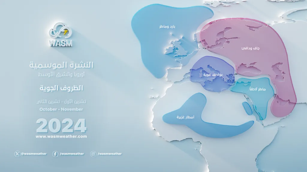
It is expected that the upcoming rainy season will be strong in the Mediterranean region, especially in the central and eastern Mediterranean area. Despite the expected late start of the rainy season in the Arabian Peninsula (during late October), rainfall rates will be heavy in the western and northern regions of Saudi Arabia and the Red Sea area, and later in Kuwait, Iraq, and northeastern Saudi Arabia.
Current Atmospheric Conditions|
With analysis of atmospheric data over the last 8 weeks, a concentration of long hot and dry periods was observed in central and eastern Europe, temperature drops below average in most of the Mediterranean region but with an increase in Mediterranean sea surface temperatures, and increased rainfall rates in the Arabian Peninsula.

With the beginning of atmospheric cooling due to the climatological start of autumn and the increasing refraction of the sun's rays, several strong storms formed in the Mediterranean region and southern Europe and central-southern Europe, resulting in early snow, torrential rains, and floods, while warm and dry periods continue in most areas of Europe.
The results of this are due to an unusual and significant weakening of jet streams, especially the subtropical jet stream, and then suddenly the polar jet stream and faster than expected from WASM's climate model for many reasons that will be explained in a detailed study.
Expected Atmospheric Conditions During Fall and Winter|
It is expected that the impact of the jet stream weakening over the Mediterranean region will reverse into specific weather patterns, and different activity for the North Atlantic, as well as different atmospheric activity in North America and intensification of strong storms toward the western United States and California region and the eastern Pacific, and very cold and dry waves in the eastern United States.
Strong Atlantic storms will be weaker than usual and more comprehensive and widespread, concentrated toward the central and western Atlantic due to changes in the course of jet streams in the Atlantic Ocean region.
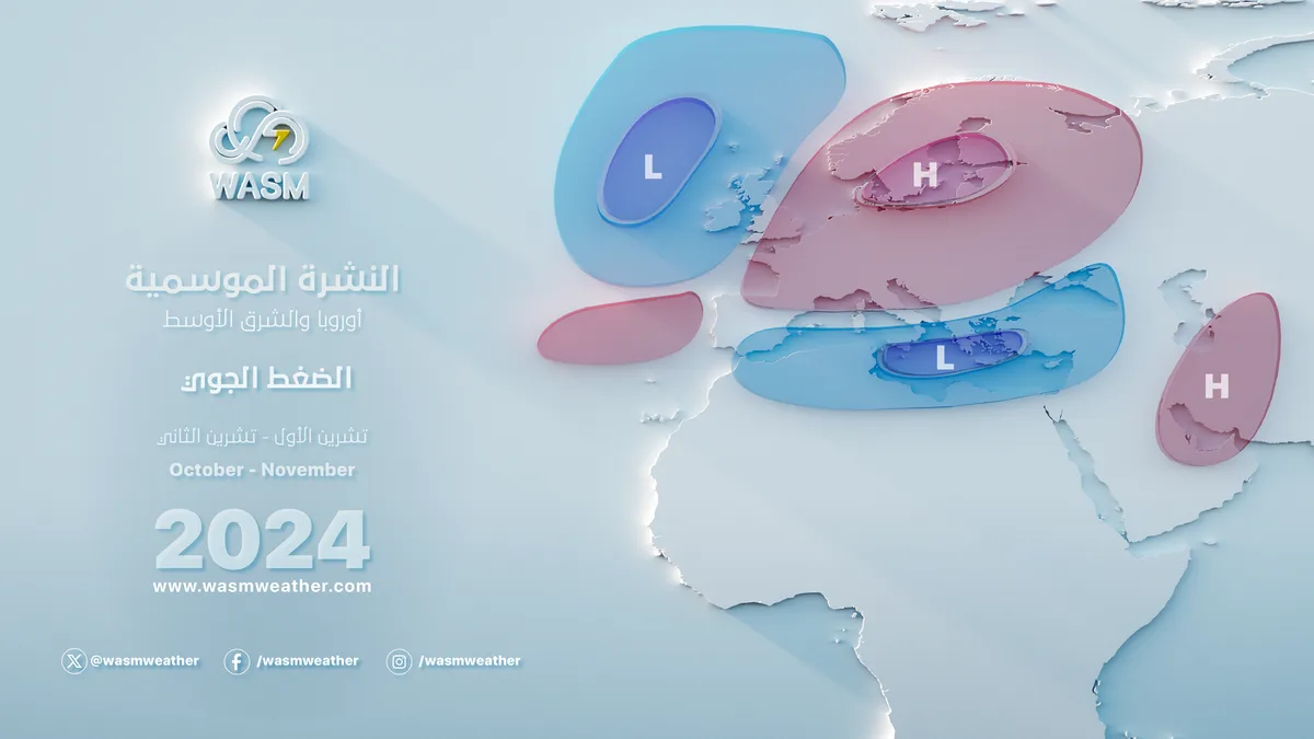
The European continent will experience long dry periods and between mild in its western regions and cold and dry in its eastern regions, with periods of strong and short activity in some periods concentrated more during the early fall season.
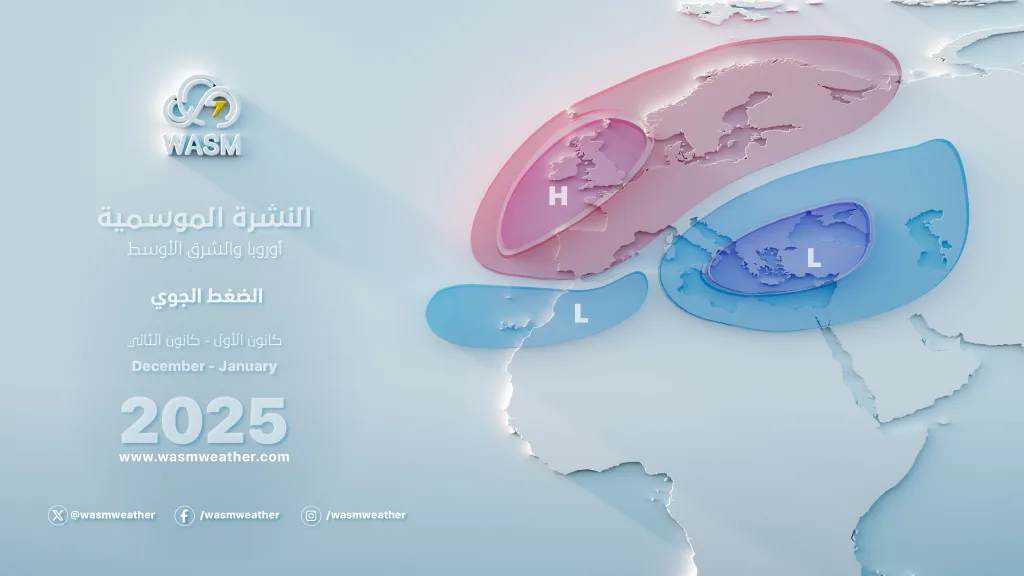
The Mediterranean will be highly turbulent and stormy throughout the expected rainy season. These storms will concentrate toward the central Mediterranean at the beginning of fall, and gradually will increase toward the eastern Mediterranean while continuing throughout the entire Mediterranean region.
The Arabian Peninsula will experience a drier and warmer period with the beginning of the WASM period, but these atmospheric conditions will change rapidly with the approach of Mediterranean storms during late October. Several important rainy conditions will form that will include northern and western Saudi Arabia, the Red Sea, and northeastern Saudi Arabia, Kuwait, and Iraq. These heavy rainy conditions will also include western and central Saudi Arabia during mid and late autumn and winter, sometimes very heavily.
Arabian Peninsula..
General Atmospheric Conditions|
Control of a high-pressure, dry, and warm area in most parts with the beginning of the WASM period. By late October, what is called the Red Sea Low is expected to deepen in western and northwestern Saudi Arabia and towards the southeast Mediterranean due to the approach of Mediterranean storms to the Levant region.
A low-pressure area in western, northern, and central Saudi Arabia during mid and late autumn and winter, coinciding with the activity of frontal depressions and eastern Mediterranean storms that will be more active than usual during that period.
Weather Conditions|
A dry and warm period during the beginning of the WASM period. By late October, rainy conditions begin from the Al-Jouf and Tabuk regions and northern Red Sea area, their movement extending to the Ha'il and Medina regions. During November, rainy weather conditions are expected to extend toward most of the Red Sea area gradually starting from its north.
The Mecca area and the central Red Sea coasts are expected to experience strong rainy conditions during the second half of November and continue intermittently until winter.
Central Saudi Arabia regions will experience clear dry and warm periods during October and the first half of November. Rainy conditions gradually reach during late November and continue during winter. The western and northern regions of central Saudi Arabia (west and north of Riyadh and Qassim) are expected to have rainy conditions extend toward them during November gradually.
Kuwait, Iraq, Hafr Al-Batin, and northeastern Saudi Arabia will experience clear rainy conditions during November and December and continue during winter intermittently.
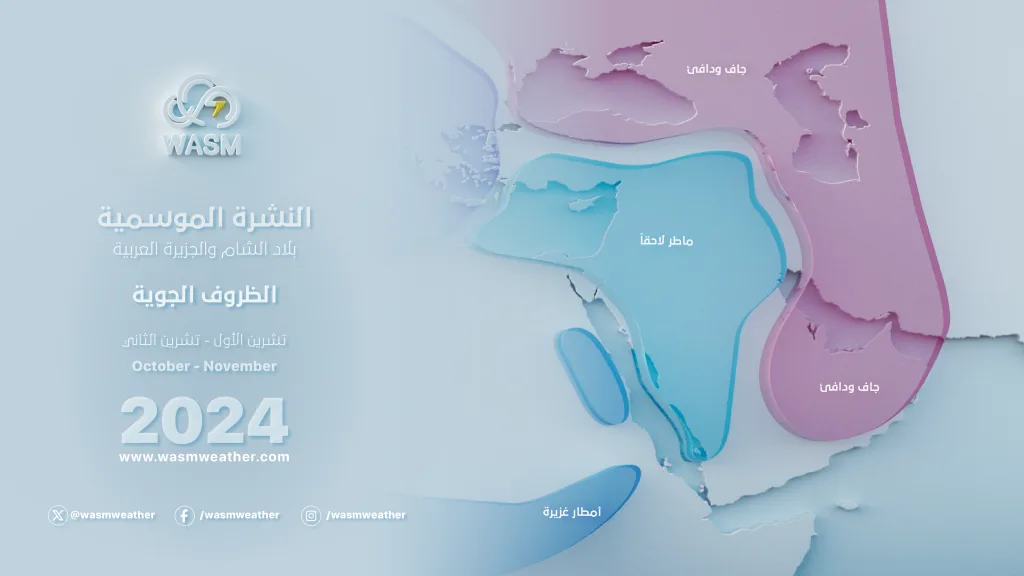
The southeastern regions of the Arabian Peninsula are expected to be drier and warmer during the upcoming expected rainy season.
Temperatures are expected to be higher during WASM but lower than usual during winter with the expectation of several very cold periods starting early and during late WASM, recurring during December but intensifying much more than usual during the second half of January.
Jordan and Palestine|
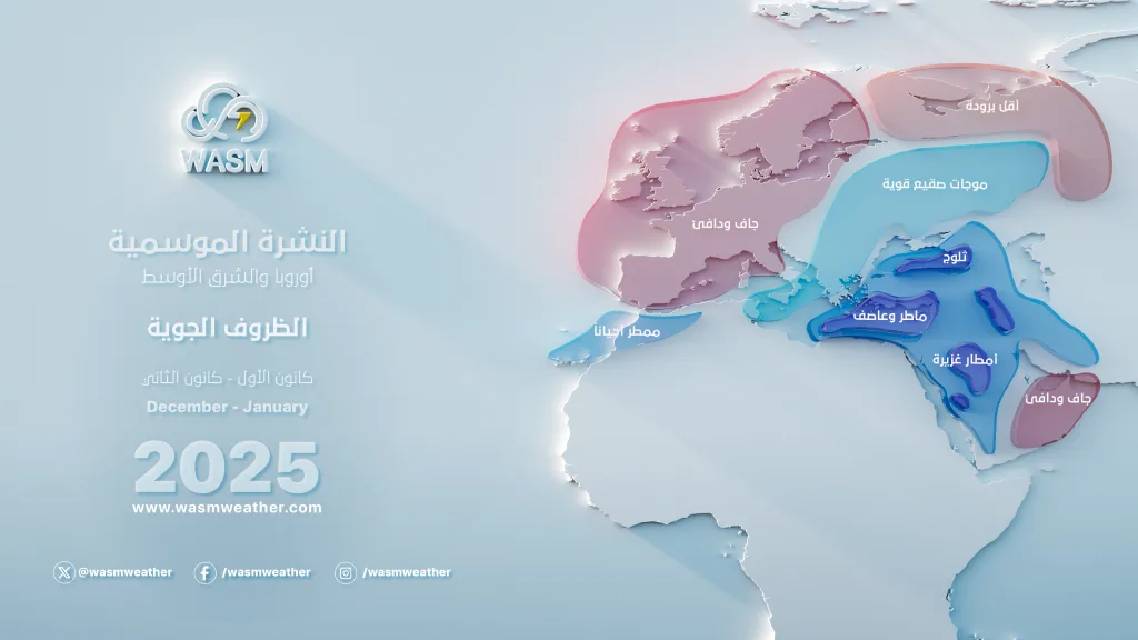
Jordan and Palestine are expected to experience another strong rainy season. The eastern Mediterranean regions continue to experience consecutive strong rainy seasons since the 2014-2015 season in an unprecedented manner in modern climate records due to changes in atmospheric circulation, and rainfall rates increased to limits of 60% in those areas, contrary to popular belief due to misunderstanding of climate changes.
General Atmospheric Conditions|
The central Mediterranean region is experiencing consecutive strong storms during the first half of October. Therefore, a high-pressure area or a dry and warm low-pressure area is expected to dominate in some periods during the first three weeks of October (a drier start).
Weather conditions change rapidly with the approach of atmospheric disturbances and Mediterranean storms toward the Levant, Jordan, and Palestine. These strong atmospheric conditions are expected to continue intermittently from late October and during November, and become more consecutive and intense from late November until January.
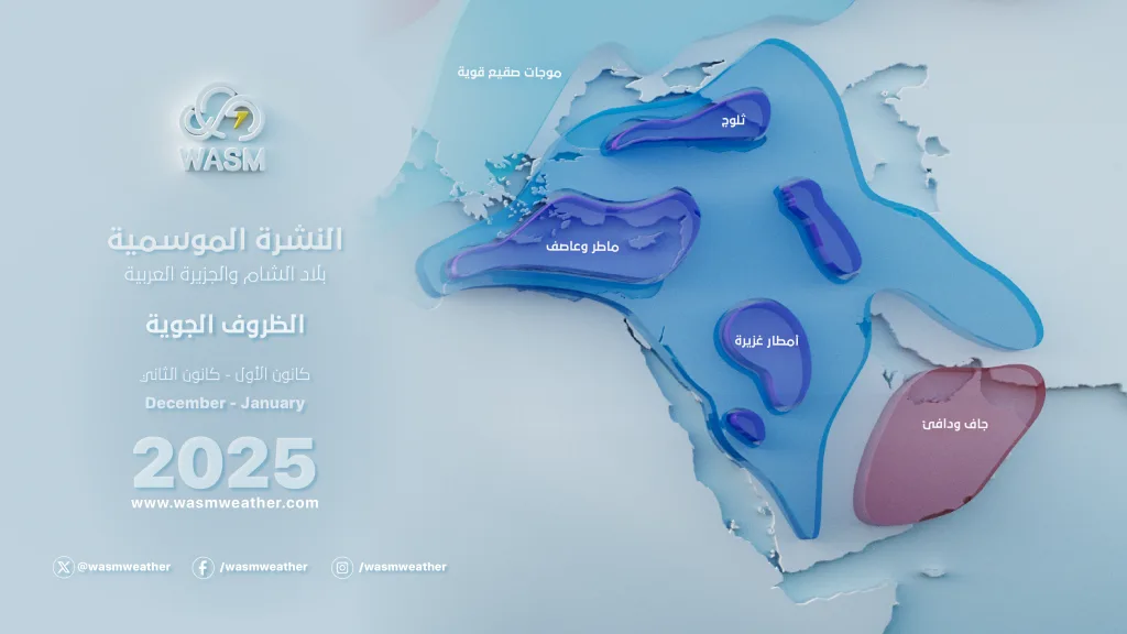
It is expected that temperatures will be below seasonal averages for most of the rainy season, especially during December and January. The chances of snow are "high" and in more than one period during some winter periods, and these periods will be clarified through detailed monthly weather bulletins.
Frost waves are likely, especially during the first half of January, with expected periods of high activity during the second half of January until February.
Maghreb Region|
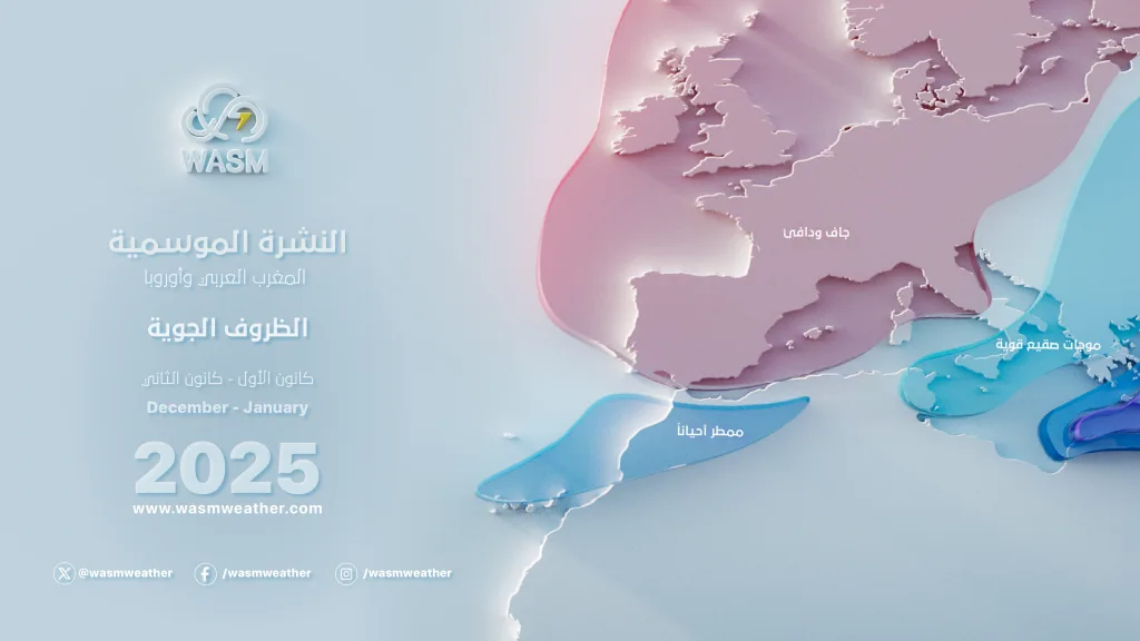
The Maghreb region is expected to break the long drought wave that affected it during previous years, especially eastern Algeria and northern Libya, due to high storm activity in the Mediterranean during the upcoming period that will continue for most of the rainy season and at different periods.
General Atmospheric Conditions|
A weak jet stream emanating from the eastern Atlantic region causes activity of the Mediterranean front in the central Mediterranean and southern Italy, resulting in several strong and rainy storms expected during the rainy season, concentrated especially in the second half of September and until the first half of October and in periods during November, and again during the first half of January.
These storms will head eastward with acceleration, especially from the second half of October and during the rainy season. Snow chances are high in some periods, specifically during the first half of January.

Weather conditions will be drier in Morocco and Spain compared with previous years and temperatures will be higher, especially during winter.
Weather Conditions|
They will be stormy and rainy with heavy precipitation in general and colder than usual, especially eastern Algeria, Tunisia, northern Libya, southern Italy, and Greece, sometimes extending toward eastern Morocco.
Snow chances will be high during the first half of January with the expected activity of the Siberian front toward the central and eastern Mediterranean region, which will result in strong weather conditions in those areas.
General Status of Major Climate Factors|
The Pacific Ocean is expected to witness a state of cold equilibrium or a weak La Niña phenomenon (where the average of zone 3.4 will reach -0.6 during October-November-December period), with rapid warming of the tropical Pacific region during December and January causing unusual atmospheric circulation and significant effect on the jet stream.
The tropical Atlantic region is expected to witness clear cooling during the upcoming rainy season, causing major changes to jet streams in the Mediterranean region and the rest of the atmosphere.
These major climate factors will significantly affect the circulation of tropical-westward propagating waves - MJO, which will take an unusual path over the tropical Pacific region and slower movement than usual in the tropical African region and areas of the Arabian Sea and the Indian Ocean, causing very significant impact on the subtropical jet stream and major weakening of it compared with the usual situation.
This system and clear changes in the atmosphere will result in unusual paths for jet streams, long dry periods - very cold or warm - in higher latitudes or middle-upper latitudes, strong and sharp Rossby waves unusual in the atmosphere that affect especially the middle-lower latitudes and subtropical regions.
WASM Climate Model|
The model was run in a main cycle on 11-9-2024, with new data collection, calibration and comparison with model results during the previous period and found rare and significant convergence reaching up to 80% during the previous period, which made us more confident in its results during the coming period.
This model operates using calibration method for statistical similarity periods flexibly, or Analogue Calibration-Dynamic-Method, a model that has been developed since 2018, and issues results at 200, 500, and 700 millibars levels in atmospheric layers, and operates in a different way and not entirely statistical, as statistical results are not accurate and give very random and temporally and spatially inaccurate results. With the development of this model, we were able to overcome these statistical problems, and we were also able to achieve precise determination of active periods temporally reaching in some periods more than 90%, especially in fall 2022, as well as fall 2019, spring 2024, and summer 2023, when we were also able through this model to precisely determine the number of tropical storms expected to form in the Arabian Sea in fall 2019.
WASM Center does not recommend relying on global climate models especially for our regions, as most Arab meteorological departments rely only on these models which reflects inaccurate results due to the lack of specialized climate models for them.
The method of issuing long-range forecasts is extremely complex, where the behavior of the atmosphere is studied with extreme precision, and knowledge of weather conditions that may result during rainy seasons after running and calibrating the model to verify its results.
The accuracy of WASM's climate model increased from 60% to around 75% during the last season, and with the addition of many developments and our ability to overcome results of statistical noise responsible for errors that may occur in long-range forecasts.