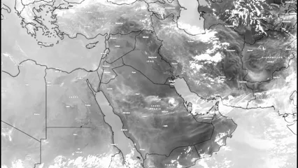
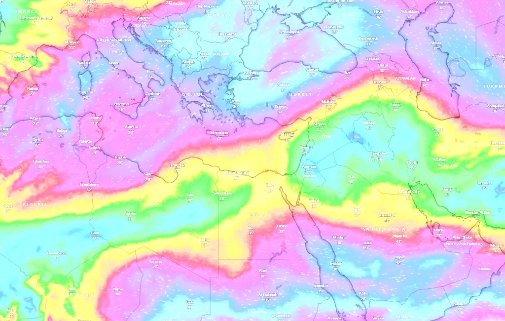
WASM- The WASM Regional Center has monitored the "Eastern Tropical Current" that blows over northern Saudi Arabia and Jordan and extending to the eastern Mediterranean in an unusual manner, resulting from strong tropical activity in South Asia and India and an unusual atmospheric circulation pattern.
The Eastern Tropical Current blows in upper atmospheric layers exceeding 14 km above sea level, resulting from air circulation around deep high-pressure centers at various atmospheric levels due to the general dynamic activity of atmospheric circulation and associated tropical activity responsible for the distribution of atmospheric pressure systems across different regions of the world, which reflect known and recurring climate patterns.
The emergence and extension of this current to mid-latitudes exceeding 30 degrees north latitude and reaching the eastern Mediterranean region and northern Egypt reflects intense tropical activity in South Asian regions resulting from the heating of the tropical zone located east of the Indian Ocean.
Causes|
Animated satellite images show the surge of this current from South Asia and from areas with significant tropical activity. Those regions recorded substantial tropical activity in recent months, which intensified with the beginning of summer due to the obvious warming of the eastern Indian Ocean, coinciding with temperature declines below normal rates in the central and western Pacific Ocean, which led to the enhancement of this activity.
Due to the significant weakening of the subtropical jet stream and its surge to north of the Sahara and the sharp undulation of the atmosphere this summer, this current surged in an "unusual" manner to the eastern Mediterranean regions, which reflects an extreme atmospheric circulation and a "dangerous" disruption in its organization that calls for all global climate agencies to pay attention to this strange circulation that may result in extremely severe weather conditions across different regions of the world.
Expected Phenomena|
This current is expected to be a clear indicator of "strong and sharp" atmospheric undulations during mid and late summer, leading to the intensification of heat waves toward the European continent and North America and parts of western and central Asia, with heat waves reaching Arctic regions sharply, leading to significant ice melting in the Arctic region, which will quickly affect the nature of water circulation in the Atlantic Ocean region.
This leads to major floods in East and Southeast Asia during the coming period, and waves of heavy rain and extensive floods in southern Saudi Arabia and its highlands, Yemen, Sudan, and even areas of the Sahara in a rare manner, with this current flowing strongly toward the Sahara and meeting the weak subtropical jet stream sometimes, causing rains to expand unseasonably to mid-latitudes and the Mediterranean region, especially its central parts during late summer.
The strong and increasing tropical activity in several tropical regions, especially South Asia and India at the beginning of summer, coinciding with the continuous weakening of the subtropical jet stream over the Mediterranean, South Europe, and East Atlantic is considered a dangerous indicator for the extension of strong tropical waves with heavy rainfall toward southwest Saudi Arabia, Sudan, Yemen, and parts of Oman and southern UAE during late summer with increased atmospheric undulations.
Heat waves are expected to remain away from the eastern Mediterranean and Levantine regions and be of less intensity than usual in northern Saudi Arabia, while they will intensify in the Maghreb regions, western Mediterranean, and European continent during mid and late summer due to the intensification of the "thermal inversion" phenomenon over northwest Africa, which extends toward Western Europe occasionally, resulting from acute and disturbed global tropical activity.
Highly Active Fall in Central Mediterranean|
With the decline of tropical activity and the continuation of the weakness of the subtropical jet stream in the Mediterranean region and East Atlantic, this will result in a very active fall reinforced by the warming of the Mediterranean in central Mediterranean regions, especially Libya and Tunisia and extending to northern Egypt in some cases.
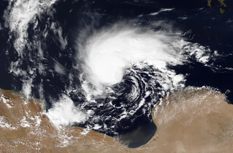
The significant tropical activity expected in the Sahara regions and the African Sahel region (located north of the equator) during the end of this summer, which will coincide with the flow of cold air through the upper and middle atmospheric layers at the beginning of fall and as a result of jet stream weakness, will greatly increase the chances of rainy storms in those regions that are unusual and similar to Storm Daniel that struck Libya in September 2023, especially with the coincidence of the intensification of the polar jet stream northwest of Europe, resulting from the warming of northern regions of the Atlantic and Pacific Oceans.
Continuation of Strong Rainy Seasons in the Southeast Mediterranean and Arabian Peninsula Regions|
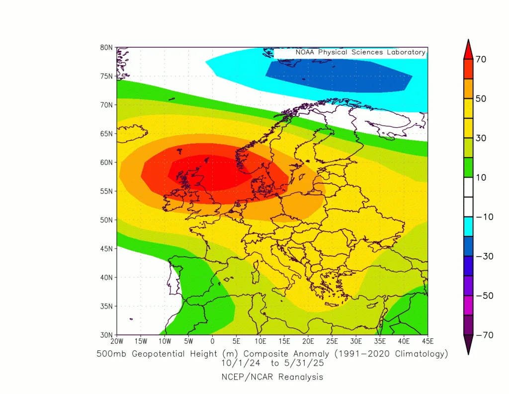
Strong rainy seasons continue to persist in vast areas of the southeast Mediterranean and north and west Arabian Peninsula regions since 2014, resulting from climate change, with Jordan and western and northern Saudi Arabia experiencing increases in rainfall rates of approximately 40-60% during the last 10 rainy seasons, which are expected to increase in severity during the coming rainy seasons with the intensification of unusual atmospheric circulation, despite the modest last rainy season (2024-2025) in some regions.
The intensification of rainy seasons over the last 10 years in Jordan, Palestine, western Saudi Arabia, northeast Egypt, and the Arabian Gulf region, coinciding with the weakness of rainy seasons in northern Lebanon and northern Syria and Iraq, is due to changes in the axes of Mediterranean low-pressure systems that have begun to be located south of Cyprus and near the coasts of northwest Palestine, resulting from the warming of Mediterranean seawaters and the weakness of the jet stream above it. This has led to increased flood and flood levels in western and northern Saudi Arabia and the Arabian Gulf region at the same time with the activity of cold fronts of these low-pressure systems and increased rainfall rates noticeably in Jordan, Palestine, and southern Syria and Lebanon.

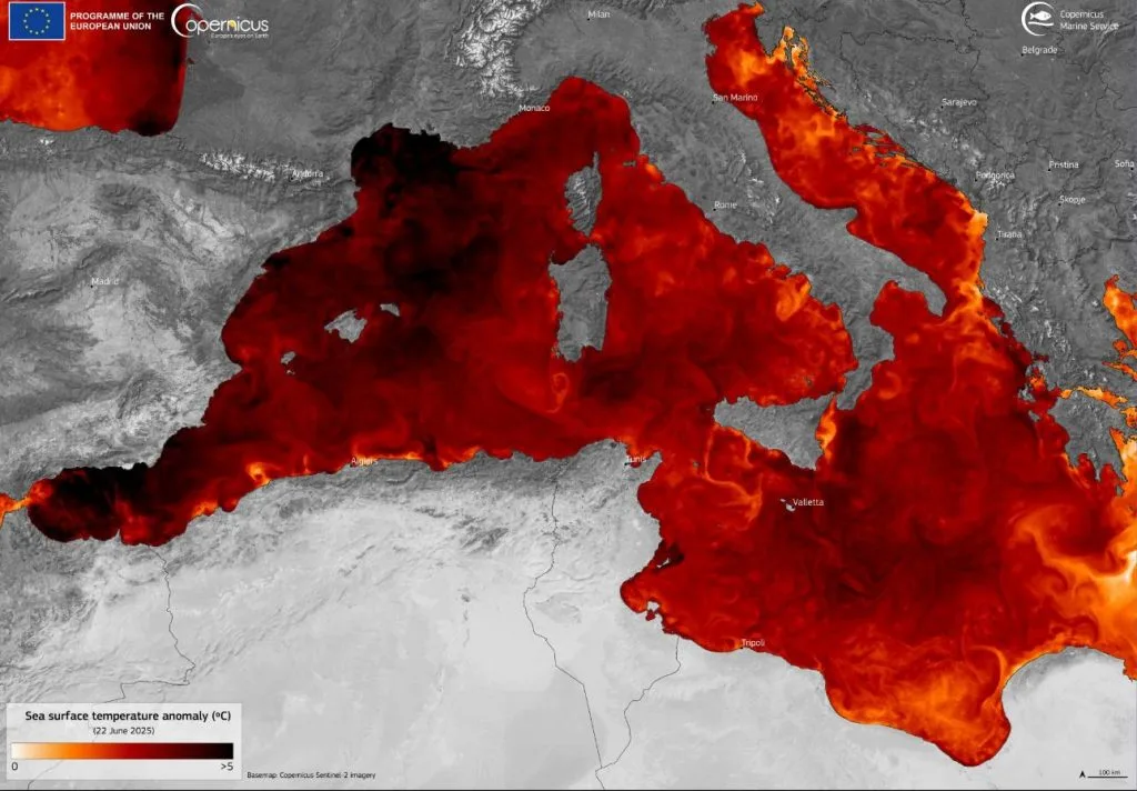
With the warming of the western Mediterranean, the concentration of thermal inversion areas over southern, western, and central Europe and the weakness of the jet stream in those regions, the continued dominance of a strong high-pressure area over most European regions throughout the recent rainy seasons has been observed, which intensified greatly this summer causing strong and successive heat waves resulting in 2,300 deaths in 12 European cities at the time of writing this report. The blowing of this Eastern Tropical Current and its extension to the eastern Mediterranean is a dangerous indicator of the severity of this circulation and a strong likelihood that this type of climate change will intensify during the coming years.
The WASM Regional Center expects the pace of global climate changes to accelerate significantly during the next 5 years, causing another type of climate change which may be acute and rapid due to the disruption that will occur in water circulation in the Atlantic Ocean region.