
Update Date | 24‑10‑2026
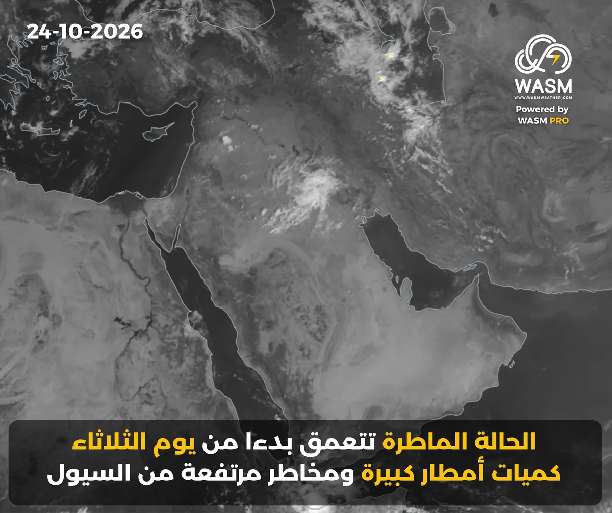
WASM – The rainfall event will deepen and become severe starting Monday/Tuesday night, then expand and become widespread on Tuesday and Wednesday, affecting all regions of the Levant, northern and western Saudi Arabia, Iraq, and later Kuwait, and will persist for an extended period.
Highly humid and strongly disturbed equatorial waves from the Arabian Sea will deepen toward northwestern Arabia, coinciding with the approach of multiple low‑pressure systems—one of which will center north of Egypt—resulting in a widespread and heavy regional rainfall event from Tuesday through the end of the week.
The climate model of the WASM Regional Center successfully detects the onset of heavy rainfall events with exceptional accuracy, outperforming all local and global sources.
The detailed seasonal weather bulletin for the Arab region for 2026–2027 has been issued.
Initial Details of the Regional Rainfall Event
The rainfall event affects wide areas from Saturday through Monday over western and northern Saudi Arabia, the Hail region, Al‑Qassim, Al‑Jawf, parts of the Northern Borders, and extends toward Iraq and the Levant—especially central and southern Syria, including parts of Jordan.
The rainfall event intensifies significantly on Tuesday and Wednesday as a deep low‑pressure system centers north of Egypt, becoming heavy and covering wide areas of Iraq, Kuwait, northern Saudi Arabia, its western regions, northeastern regions, north‑central areas, and all regions of the Levant.
Flash‑Flood Risks
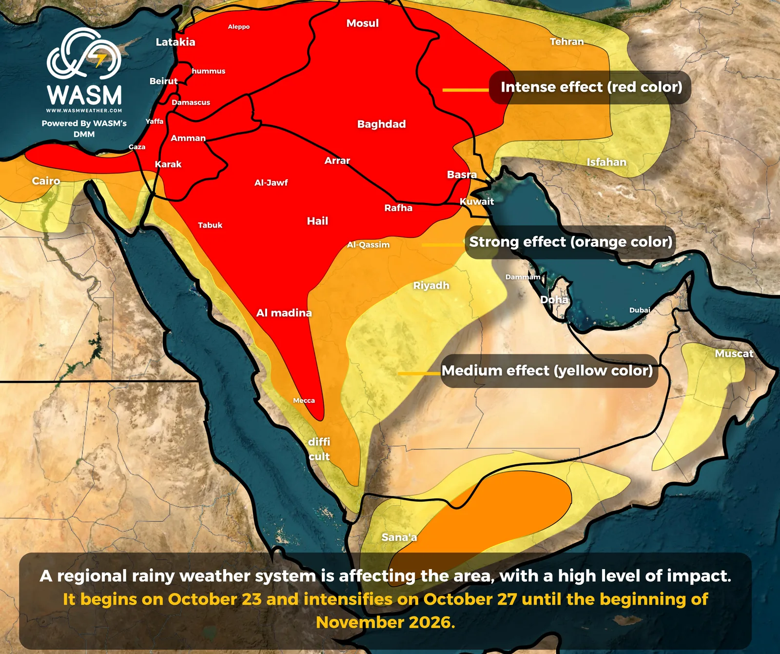
The WASM Regional Center is monitoring a regional rainfall event that will intensify significantly from Tuesday through the end of the week, covering wide areas of western and northern Arabia, Saudi Arabia, the Levant, Iraq, and northern Egypt.This event is expected to trigger a regional flash‑flood wave lasting until early November. More details will be issued progressively.
Saudi Arabia, the Arabian Gulf, and the Arabian Peninsula
The regional rainfall event begins over northwestern Saudi Arabia, Iraq, parts of the Levant, and surrounding regions, then intensifies Sunday and Monday and strengthens further during the second half of next week.
Thunderstorm rainfall extends toward Hail, Al‑Qassim, northwestern Riyadh, the Northern Borders, Al‑Jawf, and Al‑Madinah on Friday and Saturday, intensifying Sunday and Monday.
The rainfall event becomes severe from Tuesday through the end of the week, affecting Tabuk, Al‑Madinah, Hail, Al‑Qassim, Makkah, all regions of the Northern Borders, Al‑Jawf, and Iraq.It then extends toward Hafar Al‑Batin and later Kuwait by the end of the week, lasting for several days, with high flash‑flood risks in these regions.
The event affects the coasts of Tabuk and Al‑Madinah from Monday/Tuesday night through Tuesday, and parts of the Makkah coast on Wednesday.
Heavy thunderstorm showers occur at times over the highlands of Makkah, Taif, Al‑Baha, Jazan, Asir, and surrounding areas.
Thunderstorm rainfall may extend into northern Riyadh and parts of the northern Eastern Province later in the week.
The Levant
Temperatures rise with unstable weather and active winds.A deep and heavy rainfall event affects the Levant starting Tuesday and continues for several days, with high flash‑flood risks.
A low‑pressure system centered north of Egypt on Tuesday and Wednesday is expected to produce large rainfall amounts over wide areas of the Levant, with flood risks.
Jordan
Temperatures rise with unstable and turbulent weather from Saturday through Monday, accompanied by active winds and thundercloud formation in various regions.
A deep and heavy regional rainfall event begins Monday/Tuesday night over southern Jordan, extending Tuesday and Wednesday to cover all regions.Rainfall will be heavy and thunderous, with high flash‑flood risks, especially around the Dead Sea and surrounding areas.
Heavy rainfall continues intermittently until early November, with cold, winter‑like weather due to a significant drop in temperatures.
Syria
Temperatures rise with unstable weather from Saturday through Monday, accompanied by active winds at times.
A deep and heavy regional rainfall event affects Syria starting Tuesday and continues for several days, producing heavy and widespread thunderstorm rainfall covering all regions of Syria, including Damascus, with flood risks.
The rainfall event persists for a long period until early November, with cold, winter‑like conditions.
Palestine
Temperatures rise ahead of a severe rainfall event beginning Tuesday and lasting for a very long period, producing large rainfall amounts and increasing flood risks.
Temperatures are expected to drop significantly by the end of the week as heavy rainfall continues.
Lebanon
A severe rainfall event deepens starting Tuesday and during the second half of the week, lasting for an extended period.Snowfall chances increase over high mountains later in early November—very early in the season.
Iraq
Unstable weather with thunderstorm showers marks the beginning of a severe regional rainfall event.Iraq will be affected by heavy and widespread rainfall starting Wednesday and lasting for several days, with high flash‑flood risks.
For more information and smart alerts, download our mobile app available on the Apple Store and Google Play.
iOS Link: https://apps.apple.com/us/app/wasm-weather/id6810005560
Google Play Link: https://play.google.com/store/apps/details?id=com.wasmweather.app