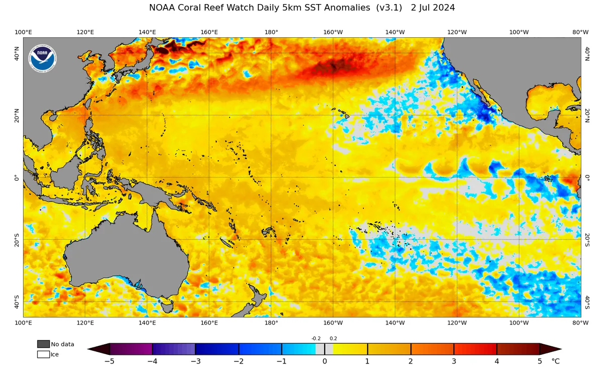
WASM – The El Niño climate phenomenon developed during autumn 2023 and affected the world's climate during the previous season, which was very evident especially in terms of high temperatures in various regions of the world, and its impact on atmospheric circulation which caused high rainfall rates in the Middle East and Arabian Peninsula region, where many areas recorded unprecedented record figures in modern climate records.
The El Niño phenomenon..
The El Niño phenomenon is the rise in water surface temperatures in the tropical region of the Pacific Ocean above their seasonal averages by approximately 0.8 degrees Celsius for a specific period lasting between 6 to 9 weeks, and this phenomenon directly affects the circulation of the tropical cell "Hadley cell" in the atmosphere, which is considered the most important cell because it plays a significant role in the path and direction of the subtropical jet stream and the manner and nature of weather patterns in mid-latitudes.
The more intense the El Niño phenomenon becomes, the more it increases the activity of the tropical cell in the Pacific Ocean (the largest ocean on Earth), and given the high specific heat of water surfaces and the slow rate of their temperature change, this gives a special and long-lasting pattern to atmospheric circulation over the Pacific region, and it is possible that the El Niño phenomenon can affect more than 40-50% of atmospheric circulation directly, which gives it great importance in determining the nature of circulation and then the nature of expected weather conditions in various regions of the world.
The most important impact of the El Niño phenomenon..
High tropical activity in the Pacific Ocean region releases enormous sensible heat energy, and the great latent energy can reach more than 4000-5000 joules per kilogram in the air in the tropical region of the Pacific Ocean, this energy is converted to heat energy with rapid and strong condensation, this heat energy is distributed on both sides of the equator during 3 weeks from the beginning of high tropical activity, and as the air that acquired great sensible heat energy descends, it increases in temperature and heating with the effect of the dynamic component when the air descends and its particles accelerate due to increased atmospheric pressure, and this increases the heat of the region
This released and excess heat energy is distributed to different regions of the atmosphere, which significantly raises temperatures in many regions of the world, and due to the position of the strong polar jet stream during the previous season, it contributed to promoting this increase, because polar air is unable to penetrate southward and contribute to the heat exchange process and alleviate the excess heat in mid-latitudes and subtropical regions, causing a significant rise in temperatures in many regions of the world and an increase in rainfall rates in many areas on the other hand, since increased evaporation and weak polar jet stream result in warm and heavily rainy weather systems.
Impact of the end of the El Niño climate phenomenon..
After understanding the main impact of the El Niño climate phenomenon, the end of this phenomenon will later reduce global temperatures due to the gradual decline of tropical activity, this gradually leads to a change in the behavior of the subtropical jet stream and an increase in its bending in various regions, which leads to strong weather conditions in various regions of the world, especially Europe, the Middle East region, and parts of North America and East Asia.
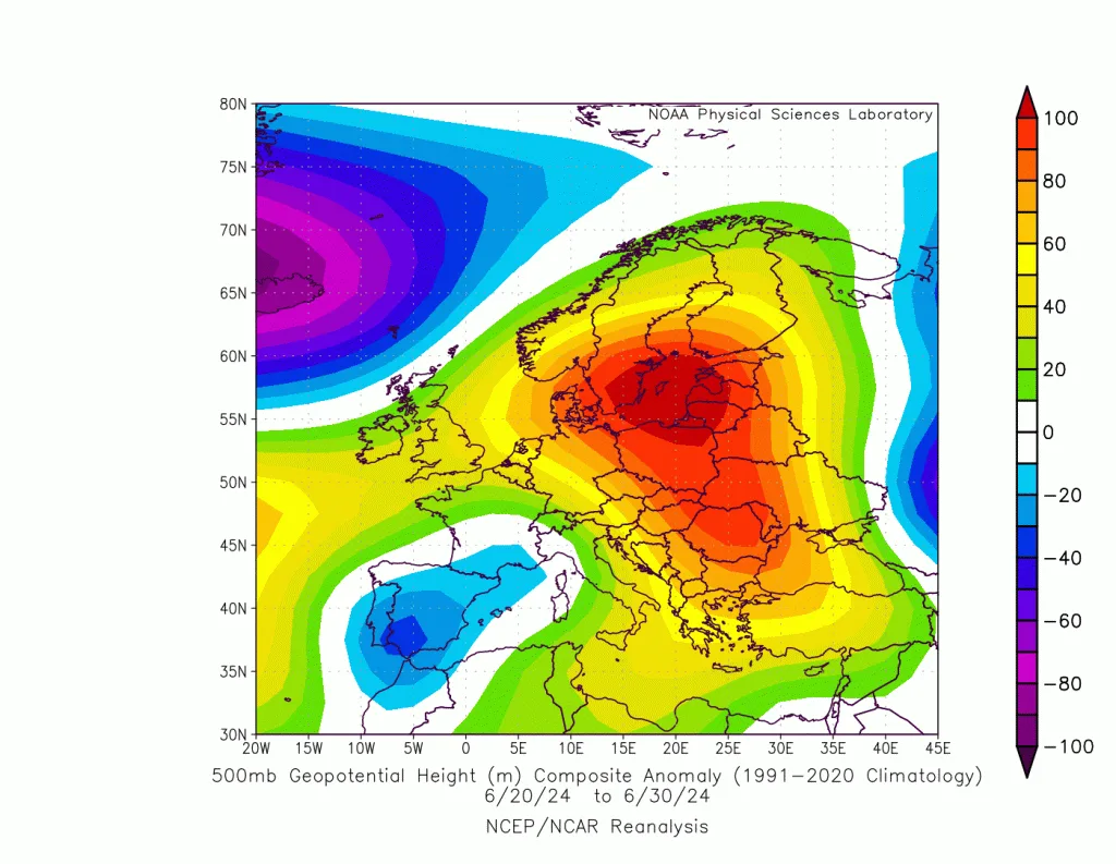
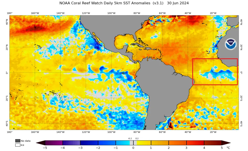
The WASM Regional Center issued a study on a very sharp temperature contrast in the Atlantic Ocean region between rise and fall which causes a significant change in the movement of the subtropical jet stream over the Atlantic Ocean, causing its sharp bending, and with the addition of the collapse of the El Niño climate phenomenon, this results in amplifying this bend more and causing severe heat waves over the European continent during this month, especially the central and eastern parts, coinciding with unusual and strong weather disturbances in those regions.
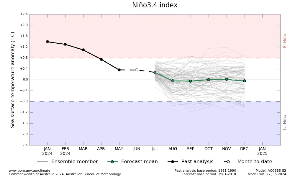
The impact of the collapse of the El Niño climate phenomenon continues for several months, and the WASM Regional Center does not expect the development of the La Niña phenomenon during the coming season, as it is expected that the phenomenon over the Pacific Ocean will be in a state of weak cold neutrality, and despite that, there are results indicating unstable and highly volatile periods especially in parts of western and southern Europe and later extending through autumn to southern and eastern Europe and the eastern and central Mediterranean regions and the Arabian Peninsula.
Change in the behavior of the polar jet stream..
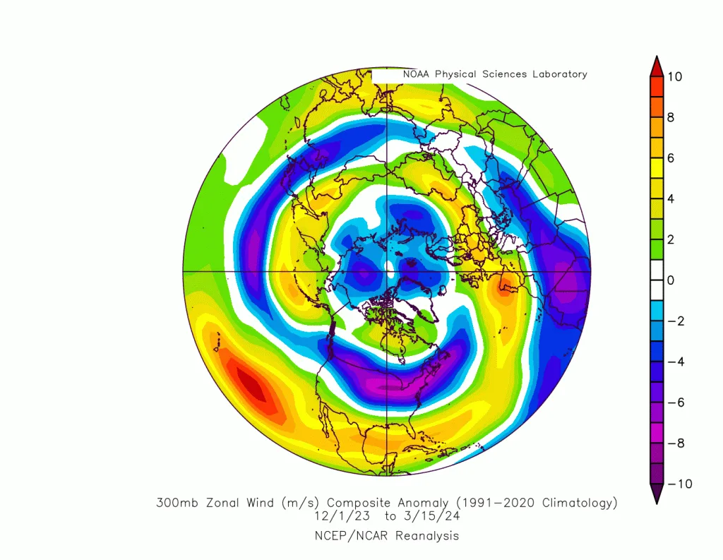
The role of the El Niño and La Niña phenomena in the behavior of the polar jet stream is less influential and clearly evident, as the circulation of the Arctic is affected by large quasi-polar weather patterns which in turn are affected by the heat of the northern Atlantic and Pacific oceans first and foremost, with the intensification of the polar jet stream, these weather patterns become very strong, causing strong circulation in the movement of polar and sub-polar winds around their centers, and weakening the likelihood of polar air reaching mid-latitudes and subtropical regions.
It has been observed through several studies that have not yet been published by the WASM Regional Center, and were simulated in its climate model, that the polar jet stream is greatly affected by the heat of northern Pacific waters first and foremost, which is indirectly affected by the El Niño phenomenon in some cases, but the previous season was not clearly affected by the El Niño phenomenon in the heat of northern Pacific waters, which is a rare occurrence, and the circulation in the Arctic was more isolated from the circulation in mid-latitudes and subtropical regions, which resulted in different warm and heavily rainy weather conditions in many regions of the world with the absence of snowfall in most mid-latitudes, which is a rare occurrence.
The effect of the strong polar jet stream in raising temperatures in the atmosphere during the previous season contributed to promoting high temperatures resulting from the activity of the El Niño climate phenomenon, resulting in high temperatures in most regions of the world.
Weakening of the polar jet stream is expected in the coming season in a clear and significant way, which allows polar air to expand easily, especially towards the east Atlantic and south of Greenland, as well as over central and western Siberia, which increases the chance of cooling the Middle East region and the eastern and central Mediterranean regions and northern Egypt and Iraq, with a high likelihood of an excellent and cooler rainy season than before.
And this leads to strong weather conditions over the European continent, especially in its southern and southeastern parts at intervals, but between these conditions there is a strong area of high atmospheric pressure due to the unusual position of the subtropical jet stream.
Study Results..
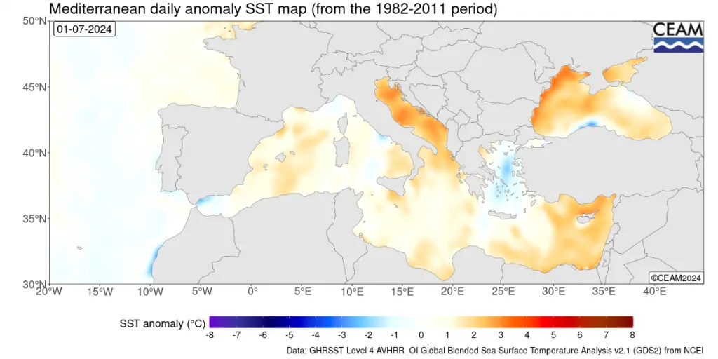
The end of the El Niño climate phenomenon will cause more strong and variable weather conditions in many regions of the world, including the Arabian Peninsula, eastern and central Mediterranean, and southeastern Europe, especially at the end of summer and during the coming season, this will also coincide with very high heat in the Mediterranean which increases the strength of these weather fluctuations..
The coincidence of the end of the El Niño climate phenomenon with a major change in the path of the polar jet stream and its weakening during the coming period will lead to a significant increase in the impact of the end of the El Niño climate phenomenon, and polar air is expected to expand towards mid-latitudes early in the coming season.
Strong heat waves expected over Europe during July and until the first half of August coinciding with strong weather fluctuations especially in western and southern Europe.
A significant contrast in the heat of northern Atlantic waters compared to its tropical and subtropical parts and near the coasts of Africa, increases the intensity of the bending of the subtropical jet stream.
And among the above points, it is noted from the study results a high probability of strong and extremely extreme weather conditions occurring around various regions of the world affecting Arab countries at the same time.
Recommendations..
Many Arab countries still misunderstand the impact of climate changes and believe that these changes are only a matter of rising heat and declining rainfall, and these beliefs are incorrect, as climate changes have caused a very significant increase in rainfall rates in the Middle East region, exceeding 60% in some Arab countries, especially Jordan and parts of Saudi Arabia and the Arab Gulf states, and coinciding with an increase in temperature by an average of one and a half degrees Celsius, but with the occurrence of sharp temperature fluctuations even in summer.
This report and this study are extremely important to prepare for the expected weather conditions in the Arabian Peninsula region and the Middle East, Egypt, Iraq, and also central Mediterranean region, as it is expected that the probability of a sharp and strong heat wave at the end of summer will increase, coinciding with the occurrence of unusual weather disturbances, especially in the Arabian Peninsula region which will result in very large rainfall rates.
Weather disturbances will strongly affect the central and eastern Mediterranean countries with the beginning of the rainy season, especially Libya, northern Egypt, and eastern Tunisia extending later to the Arabian Peninsula and the Levant countries, and in an unusual manner during some periods due to unusual behavior of the subtropical and polar jet streams at the beginning of the rainy season.
Understanding true climate changes through studies and data away from misleading information that spreads increases the likelihood of preparing for them and reducing their losses and benefiting from them, especially those that caused a significant increase in rainfall rates.