
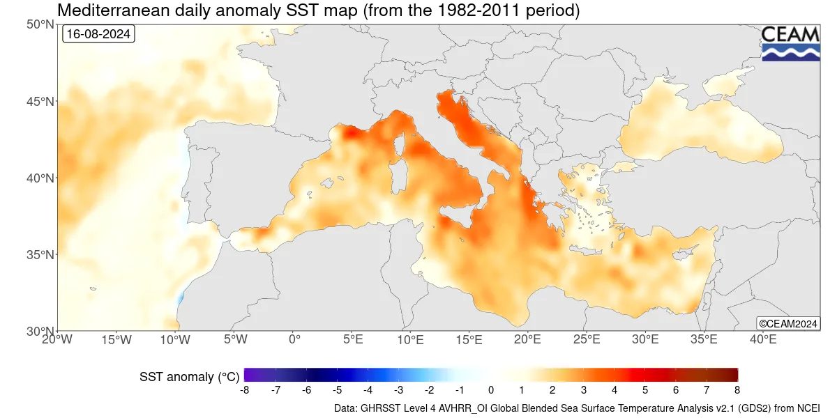
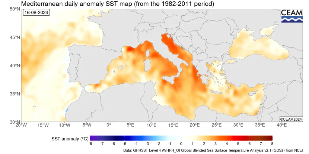
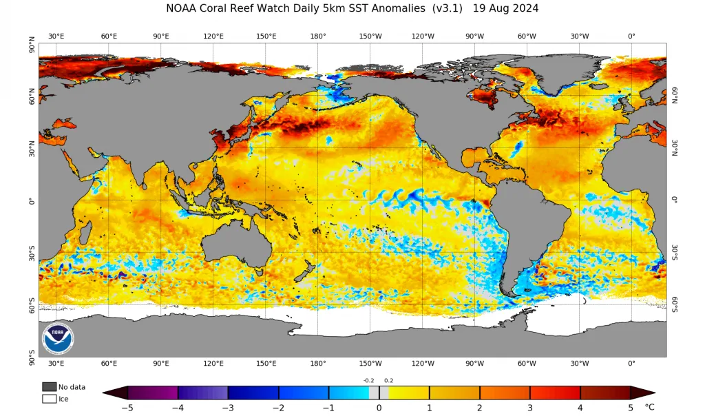
WASM – The average temperature rate in the Mediterranean region has risen to the highest levels based on (recent climate records), coinciding with important rotational changes in the atmosphere and due to obvious changes in the temperatures of the major oceans. Since thermal effects alone in the Mediterranean region are insufficient to produce significant changes, major changes have been observed in the jet stream path since the end of June 2024.
This resulted in different outcomes on the ground compared to some seasonal forecasts that indicated a very hot summer in the Levant region and northern Saudi Arabia. The results of WASM Regional Center's climate model were the most accurate in the region, providing different results because it operates using flexible calibration for periods of similarity, reaching accuracy of up to 90% in some periods, which is a very high figure for long-range climate models.
High Mediterranean Sea Temperature..
High Mediterranean sea temperature means the presence of very high latent energy, but it remains "latent," meaning it has not yet been released to become thermal energy that converts into kinetic energy powering active weather systems and baroclinic atmospheric lows. The absence of significant dynamic activity will not greatly affect weather conditions.
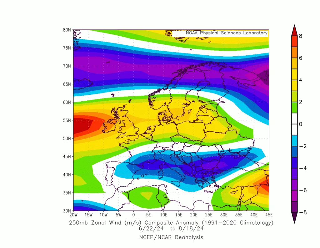
However, a study of the expected jet stream during the upcoming rainy season conducted by WASM Regional Center, using WASM's climate model which recorded exceptional accuracy in expected weather conditions during July and August, particularly in the eastern Mediterranean and southwest Saudi Arabia, Yemen, and the European continent, revealed an unusual and rare phenomenon: a sharp weakening of the subtropical jet stream starting from southern Britain through the central and eastern Mediterranean. This contributed to stimulating the strength of the Azores high-pressure system in the Mediterranean and a major retreat in heat waves, a rare occurrence for July and August in the eastern Mediterranean and northern Saudi Arabia regions.
This atmospheric organization will appear clearly during the second half of September and better during the end of October through the winter period in the central and eastern Mediterranean, northern and western Saudi Arabia, and central Saudi Arabia, Iraq, and surrounding areas, where it will concentrate over southern Italy, Tunisia, eastern Algeria, and Libya, and at times toward the eastern Mediterranean, then concentrate more clearly during mid-autumn over the eastern Mediterranean region.
The weakening and splitting of the subtropical jet stream in the eastern Atlantic to southern Europe is matched simultaneously by a major intensification of the polar jet stream in western Europe, then a sharp bend in the eastern European continent extending to eastern Turkey, clearly showing how the Mediterranean front develops and how Mediterranean atmospheric lows will intensify as they move eastward. The high Mediterranean sea temperature increases the strength of these weather systems simultaneously with the flow of cold polar air toward their centers as they approach the Aegean Sea, exposing central and eastern Mediterranean areas to a "high" probability of strong Mediterranean storms. This does not mean only subtropical weather systems, but rather mid-latitude storms and Mediterranean storms—baroclinic frontal weather systems.
What also exposes the region to a significant probability of flooding, which has increased in recent years, particularly in the eastern Mediterranean, northern Egypt, and western and northern Saudi Arabia, is the expected very active behavior of the Red Sea Low (RSCZ) for reasons mainly related to the Siberian front that will deflect slightly toward the east, Iran, and the central Arabian Sea region. This greatly increases the probability of western and northern Saudi Arabia and Red Sea coasts receiving large amounts of rainfall during mid-autumn, particularly with the activity of Mediterranean fronts.
High Mediterranean sea temperature may generate significant thermal energy if important dynamic activity occurs, and this is expected based on the unusual movement of the subtropical jet stream and sharp bending of the polar jet stream over eastern Europe. This thermal energy may reach more than 3500 joules per kilogram of air in some periods, increasing the chance of early subtropical storms in the region, primarily affecting the eastern Mediterranean and northern Egypt.
High probability of subtropical storm formation..
Given the weakness of Arab studies regarding the reality of climate changes in the Arab region and their focus on non-essential weather conditions (such as exaggeration in describing heat waves or inaccurate reports on rainfall rates), these climate changes have caused significant damage to the Arab region, particularly Mediterranean areas, due to results contrary to weak studies and increased damage, especially regarding severe drought waves in western Mediterranean that have persisted for many years, and heavy rainfall rates in the eastern Mediterranean which recorded a significant increase reaching 60% above their seasonal averages.
Given the high temperature rate reaching up to 31 degrees Celsius in the eastern Mediterranean and parts of its center, and for reasons not completely clear, the results in barotropic instability activity during the final stages of baroclinic atmospheric lows, supported by the weakening of the subtropical jet stream and bending of the polar jet stream, will generate severe and record barotropic activity in the region, which clearly appears in WASM's climate model results during autumn through the beginning of winter and later during spring.
Results showed that the probability of subtropical storm formation is very high during the third week of September and after mid-month will concentrate mainly over the eastern Mediterranean region. The flow of cold air masses resulting from an unusual weakening of the subtropical jet stream over the Mediterranean region, coinciding with high surface water temperatures, will greatly increase this probability. As we mentioned, high temperature alone is insufficient without the presence of important dynamic activity.
High probability of polar waves..
The combination of results from the weakening of the polar jet stream and its sharp bending in the eastern Mediterranean and eastern Turkey, coinciding with high Mediterranean sea temperature and the presence of great kinetic energy resulting from high thermodynamics, will cause a high probability this season for polar air to reach directly to central Saudi Arabia during January 2025, supported by the humid Mediterranean front along the central and eastern Mediterranean and the rapid movement of these weather systems eastward by the polar jet stream.
Red Sea Low..
The study of characteristics of the high eastern Mediterranean temperature rise, and the study of hot spots, where an important hot spot was observed over the southern coasts of Palestine, Gaza, and up to northern Sinai, reaching more than 31 degrees Celsius, which parallels the axis of the Red Sea Low extension toward the eastern Mediterranean, will greatly reinforce the strength of the Red Sea Low during autumn and change its axis westward more than usual based on the bending of the subtropical jet stream.
With the study of the Siberian high-pressure axis that will tilt noticeably eastward and also southward more than usual, extending to Iran and northern Arabian Sea region, this will result in a great moisture tunnel penetrating toward western Saudi Arabia, eastern Egypt, along the Red Sea, and extending to Jordan, Palestine, and eastern Mediterranean, then extending toward Al-Jouf and northern Saudi Arabia, Iraq, Kuwait, western and central Saudi Arabia. With the activity of Mediterranean fronts penetrating continuously, especially during autumn, this will increase the chance of floods and strong torrents in the region, particularly over Mecca and Red Sea coasts.
Eastern Tropical Waves..
With the study of eastern tropical waves or equatorial Rossby waves and Kelvin waves resulting from them, particularly in the Arabian Sea and western Indian Ocean, and with the expected major weakening or even non-development of the La Niña phenomenon and the continuation of cold waters over Indonesian coasts, and the extension of the Siberian-Arabian arm toward the Arabian Sea, this increases the probability of active tropical storms during October and November toward southern and even southwestern Saudi Arabia, further increasing moisture flow to the region. These tropical weather systems will take westerly paths, especially with the expected high activity of equatorial Kelvin waves which will feed the axis of the highly effective Red Sea Low positioned in central and western Saudi Arabia and its northern parts up to the eastern Mediterranean.
According to a study issued by WASM Regional Center, high eastern Mediterranean sea temperature greatly increases the probability of floods and torrents over western and northern Saudi Arabia, the eastern Mediterranean region, and northern Egypt, with very high probability during mid-autumn.
WASM Climate Model..
WASM Regional Center will issue the seasonal bulletin for the 2024-2025 season, which is distinguished by the highest accuracy in the Arab region and the Arabian Peninsula due to the operational method of this climate model, which operates using calibrated methodology for periods of similarity in previous years. According to initial results, the upcoming rainy season will be strong in the region, particularly western and northern Saudi Arabia, the Levant region, and northern Egypt, as well as central Mediterranean and southern Europe. More details will be available through the detailed seasonal bulletin soon.