
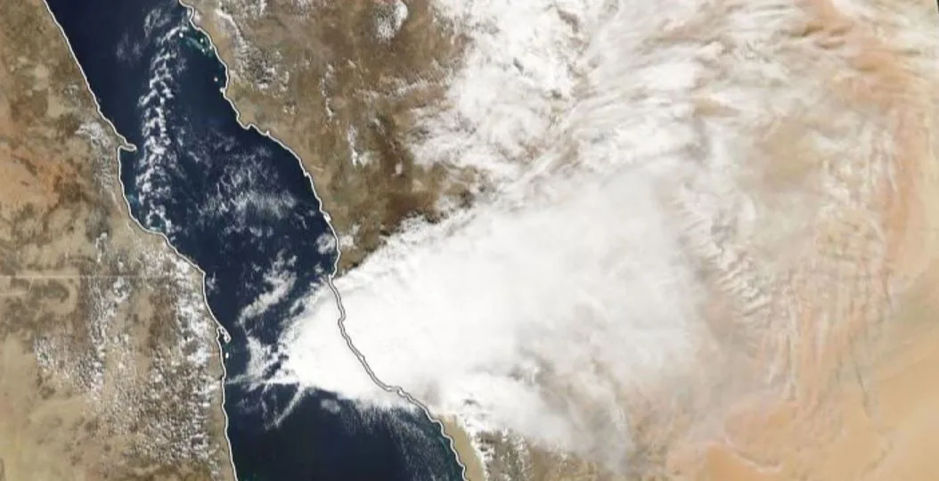
WASM – Red Sea Low or RSCZ (Red Sea Convergence Zone), which is the region where cooler northern winds converge with more humid southern winds pushing from the south. This distinctive thermal low-pressure system extends vertically up to 1500-2000 meters (above the atmospheric boundary layer) and causes severe rainy conditions during the rainy season in the Middle East region.
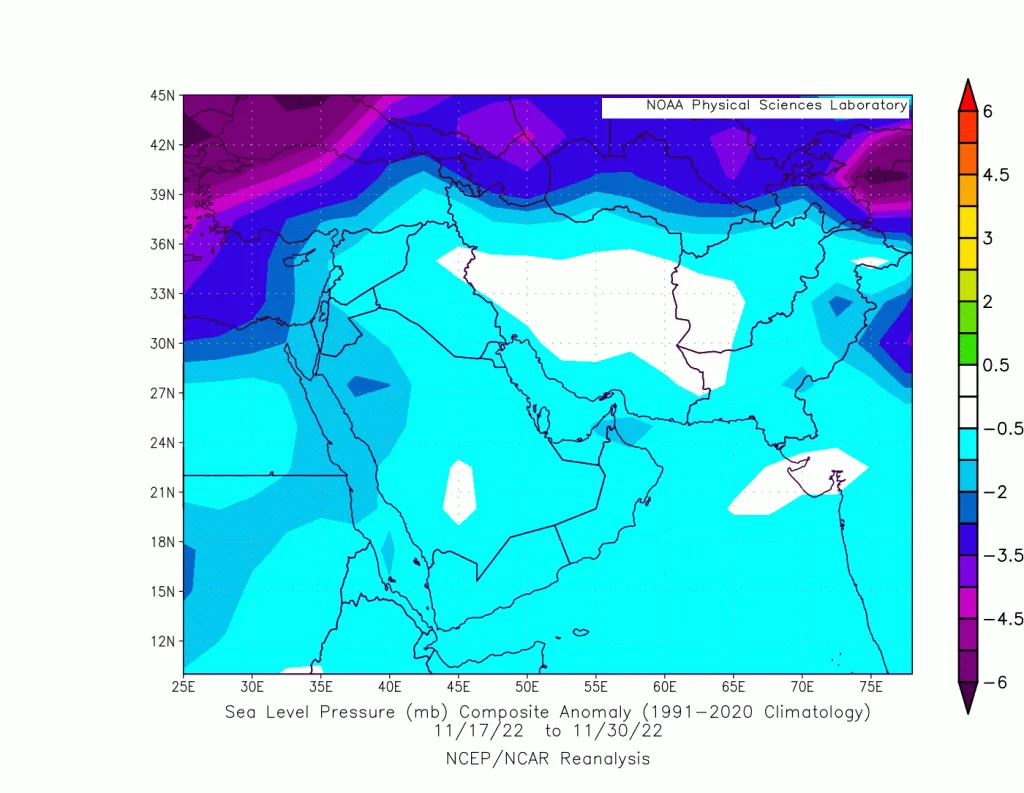
In recent years, its impact has been observed to intensify, particularly over the western and southern sectors of Saudi Arabia, extending toward northern Saudi Arabia, Kuwait, Iraq, Jordan, and Palestine, reaching Egypt. The increasing impact on these areas has been closely linked to an unusual atmospheric circulation pattern in recent years, which has begun to take on a semi-permanent level as a result of the subtropical jet stream's course following a more stable path.
In this article, changes in Red Sea low activity have been monitored since 2010, and an increase in its activity has been observed, particularly in northern and western Saudi Arabia and the Red Sea region.
Characteristics of the Red Sea Low..
The Red Sea low is a type of thermal system that takes the central and southern Red Sea region as its center from the end of September to the beginning of June, and its location changes according to the temperature of the Red Sea region and its connection with the southeast Mediterranean region and the temperatures of the surrounding areas of the Arabian Peninsula.
This thermal system, which forms as a result of the temperature difference between the Red Sea region and the surrounding cooler areas, extends vertically above the boundary layer compared to more conventional thermal systems such as the Indian monsoon low, which may not exceed vertical thicknesses of 500 meters. This reflects its impact on the dynamic and baroclinic activity it causes during weather conditions.
The Red Sea low (RSCZ zone) is usually positioned during autumn toward the north and west of the Arabian Peninsula and the northern Red Sea region, extending to Jordan, Palestine, and northeastern Egypt. During winter, this axis moves from the central western sector to Kuwait, passing through central and northeastern Saudi Arabia. During spring, this axis shifts toward the southern Red Sea and southern and central Saudi Arabia, and may merge with the subsidiary centers of the Indian monsoon low during late spring and early autumn.
The Red Sea low system directly combines with the ITCZ zone located south of Sudan and above the equator, or what is called the Sudanese thermal low, which is often responsible for drawing trade winds from the Arabian Sea region during the rainy season to the Red Sea region and enhancing humidity levels.
This atmospheric system is considered the main link in the moisture channel flowing from the Arabian Sea and the Indian Ocean (tropical and subtropical regions) and is greatly affected by tropical waves that move along the equator. Its axis and activity change according to tropical waves and the nature of subtropical jet stream activity.
Increased activity of the Red Sea low in recent years..
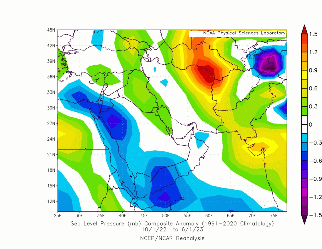
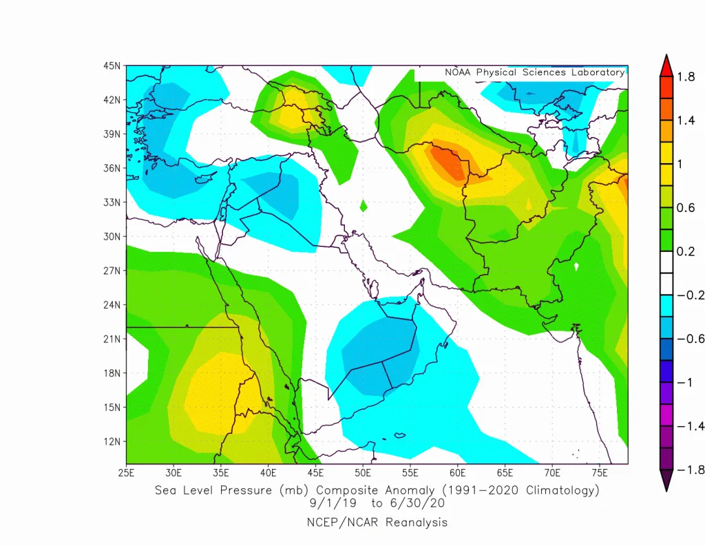
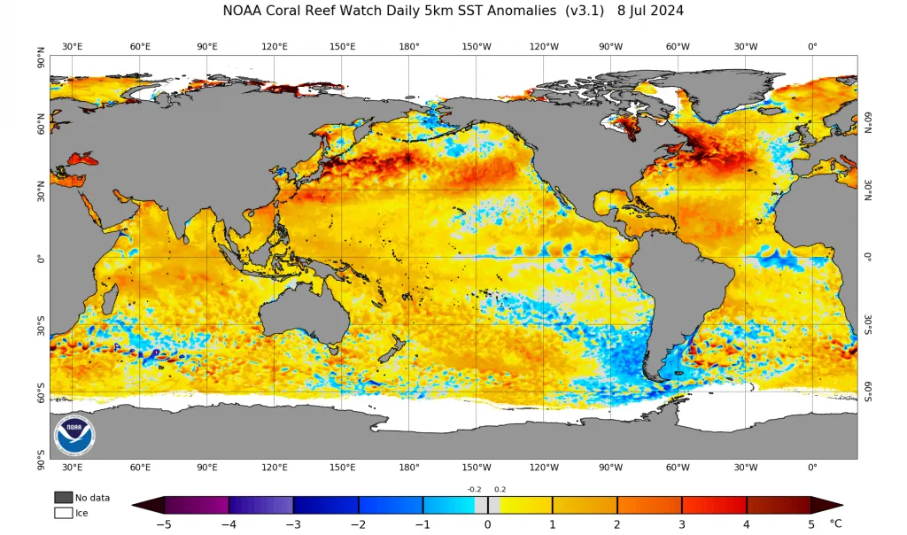
An increase in Red Sea low activity has been observed in recent years, specifically since the 2014-2015 season. This was clearly linked to the warming of water bodies, particularly the western Indian Ocean, the Red Sea, and the eastern Mediterranean. These water bodies contribute to a more pronounced decrease in atmospheric pressure as it is a seasonal to semi-permanent thermal system.
Areas where increased activity was observed..
Increasing deepening of the atmospheric system over southern Saudi Arabia, extending to the central and northern Red Sea, and most significantly over the Al-Jouf region, Jordan, northeastern Egypt, and the southeastern Mediterranean (deepest between 2010 and 2024) has been observed.
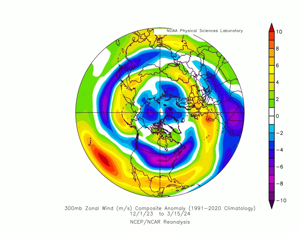
Centers of system deepening for RSCZ have clearly increased over southern Saudi Arabia and south of Riyadh, as well as near the UAE and Oman. An increase in atmospheric pressure values over the ITCZ region south of Sudan has been observed, which may be explained as a result of increased activity of Cypriot and Egyptian lows in recent years resulting from the warming of the eastern Mediterranean. This leads to continuous jet stream breaking over the eastern Mediterranean, which increases negative dynamic activity downward as a result of Convergence zone activity over North Africa in the upper atmosphere layers and an increased chance of atmospheric pressure rise due to vertical current movements downward.
Egyptian and Cypriot atmospheric lows..
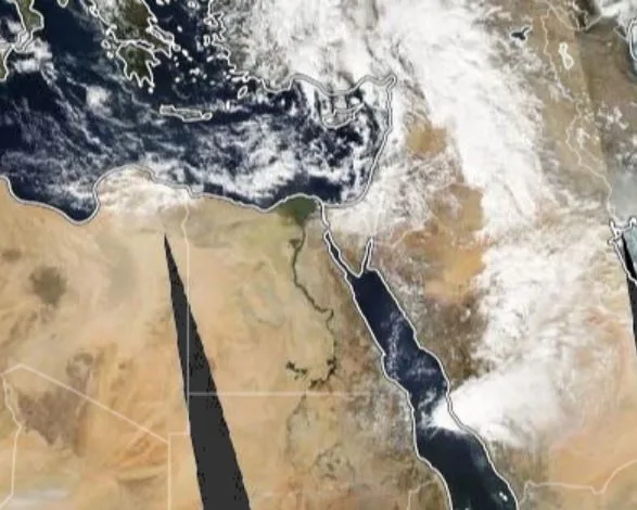
While studying the case of 24-November-2022, which caused the worst flood wave in Mecca in modern climate records, with rainfall amounts approaching 300 mm in Jeddah city, and with the deepening of the RSCZ zone specifically over the central western sector and then northward, particularly toward northern Egypt and Tabuk, observing the centers of the Egyptian low that follows a path close to khamsin atmospheric lows but deepens more over the southeastern Mediterranean and northern Red Sea, Egyptian lows or any baroclinic or dynamic low-pressure system causes the activity of strong cold fronts synchronized with the activity of the Red Sea low from the south. The absence of these lows means that the effectiveness of the Red Sea low will remain weak, limited, or even non-existent.
The RSCZ zone is sharply linked with Egyptian and Cypriot lows and simultaneously with baroclinic lows in northern Arabia, the spark of which begins to form east of Tabuk highlands due to the Lee-low phenomenon that impedes the movement of surface cold fronts and promotes the formation of other atmospheric low centers. This family of dynamic or baroclinic atmospheric lows is among the most important factors that increase the effectiveness of the Red Sea low. The chance of their formation increases when the subtropical jet stream bends and pushes cold pools through the upper and middle atmospheric layers, which trigger atmospheric instability and the formation of these atmospheric systems.
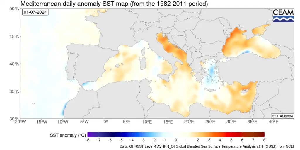
The elevated temperature of the eastern Mediterranean in recent years has contributed greatly to increased atmospheric activity in the central and northern Red Sea region, the Al-Jouf region, Tabuk, Jordan, Palestine, and northeastern Egypt through intensified activity of the thermal Red Sea low (RSCZ).
Peak activity of the RSCZ zone..
This zone becomes more active starting with the rainy season in autumn, concentrating toward northern Saudi Arabia and Jordan as these water bodies retain summer heat and due to their elevation compared to the beginning of temperature decrease initially toward the eastern Mediterranean and northern Saudi Arabia region. This movement gradually shifts south as we move deeper into the rainy season with sharp temperature gradients.
Due to temperature differences during spring, this zone is positioned over the Empty Quarter desert and southern Saudi Arabia, which increases the chance of strong conditions toward central and southern Saudi Arabia. Temperature rise above seasonal averages and the ease of subtropical jet stream bending toward the south further increased its strength. Peak activity was more intense than usual, causing record rainfall rates in both southeastern Arabia, the UAE, central western Saudi Arabia, Jordan, and Kuwait.
The El Niño climate phenomenon linked with positive Indian Ocean dipole polarity..
With the increasing occurrence of El Niño phenomena in recent years, especially since the 2015 season which witnessed one of the strongest El Niño events, this coincided with positive Indian Ocean Dipole (IOD) activity that contributes to warming the western Indian Ocean region and greatly increasing tropical wave activity, particularly those present in the central Arabian Sea. This was clearly linked to the decline in surface atmospheric pressure values below their averages in southern Arabia at the same time, along with trade wind movement and the path of pressure decline to Jordan and northern western Saudi Arabia.
Summary..
By the end of this report, it was noted that the activity of the Red Sea low (RSCZ) has clearly increased over southern Saudi Arabia, central, western, and northern sectors, and in the eastern Mediterranean and Jordan regions primarily. The most affected areas were the Mecca region, Jordan, northeastern Egypt, central Saudi Arabia, Kuwait, the UAE, and Oman, and extreme rainy cases have increased with increased rainfall rates in the region.
- The warming of the eastern Mediterranean caused an increase in the activity of Egyptian and Cypriot atmospheric lows, which increased the activity of the Red Sea low.
- El Niño phenomena and their connection with positive Indian Ocean activity (IOD), which raised Arabian Sea temperatures and increased the flow of tropical waves toward the region.
- Floods and torrents in the central western sector were primarily linked to the activity of Egyptian and Cypriot lows and the northern Arabian low, which enhanced the activity of the Red Sea low.
- Historic rainy conditions in the UAE and Oman resulted from Red Sea low activity in southern Arabia due to the warmth of the Arabian Sea region and the bending of the subtropical jet stream in recent years toward the eastern Mediterranean basin and northern Arabia.
- This was greatly linked to the elevated temperature of the eastern Mediterranean and the Arabian Sea.
- RSCZ zone activity requires atmospheric systems that lead to its effectiveness, particularly Cypriot lows, Egyptian lows, and northern Arabian low.
- Red Sea low activity may be linked at the end of rainy seasons with early heat waves in the eastern Mediterranean and northern Saudi Arabia