
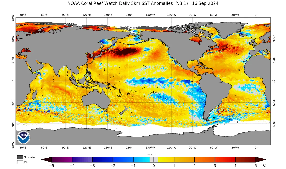
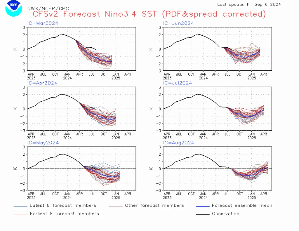
WASM - The WASM Regional Center continues to monitor the cooling phenomenon in the tropical region of the Pacific Ocean, which continues to face severe slowdown in the cooling process, while facing a sudden and unusual warming process in the eastern part of the tropical Pacific region, which is contrary to American climate model data, specifically the CFC model which faced "severely reduced" accuracy during the summer period in the tropical Pacific region.
The WASM Regional Center is monitoring the scientific reasons for this slowdown in the cooling process and the failure of the La Niña phenomenon to develop contrary to expectations, and considers this to have a significant impact on atmospheric circulation and the changes that occurred in the forecasts of global climate models, as well as the extreme weather conditions occurring around different regions of the world, especially in the Mediterranean region which is experiencing the most extreme weather conditions.
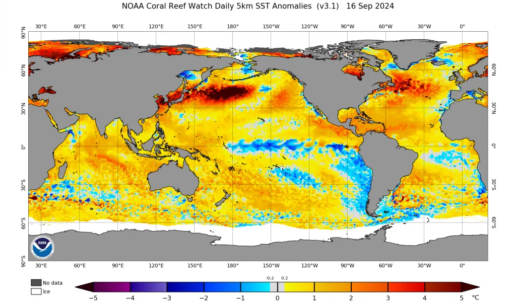
The La Niña and El Niño phenomena greatly affect the path, intensity, and nature of the subtropical jet stream circulation and atmospheric circulation, and these phenomena are considered among the most influential on the nature of atmospheric circulation.
- Major weakness in trade wind speeds..
Trade wind speeds in the tropical Pacific region continue to face significant weakness compared to the La Niña phenomenon, and after their values improved relatively during the last two weeks, their speed has declined again significantly and rapidly. The eastern region is also facing an unusual warming process and a return of rising temperatures in the eastern tropical region, as if resembling a weak eastern El Niño condition, which is surprising compared to global climate model forecasts.
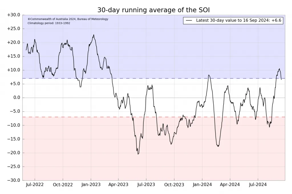
- Sub-deep cold waters not clearly distributed..
The process of upwelling of cold waters from sub-deep regions in the tropical Pacific Ocean is also linked to the activity of trade winds across the subtropical band in the Pacific Ocean and their impact from the Ekman Transport phenomenon, so it appears that the process of upwelling waters from the depths remains weak, timid, and unclear compared to strong and clear La Niña phenomena.
- Cooling over the last three weeks..
The cooling that occurred over the last three weeks was more pronounced compared to the summer period, but a significant decline occurred during the second week of September, especially in the eastern part with a strange and completely unexplained weakness in the trade wind speeds in the eastern tropical Pacific region, and climate models such as ECMWF and ACCESS are still succeeding significantly in forecasting the path of this phenomenon, unlike the American CFS model and also the data of the Canadian long-range model which has corrected itself in recent times.
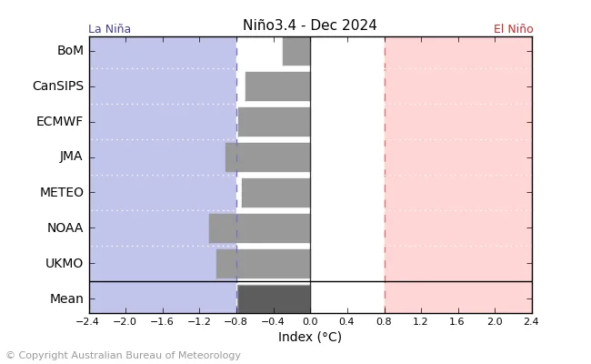
- Great heat in the Pacific region..
Although it is difficult to prove this, the Pacific Ocean region is suffering from high heat in most of its parts, especially the northern part, but it may have different results that will be explained in detailed studies through the WASM Regional Center.
- Southern Annular Mode – SAM..
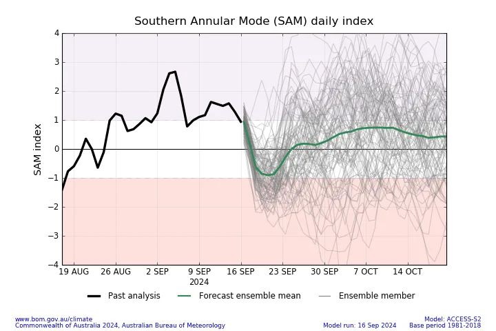
Experts from the WASM Regional Center believe that this sharp and negative Southern Annular Mode since summer is considered the main responsible factor for the weak development of the La Niña phenomenon during the summer and even into the beginning of autumn, and this oscillation continues to record negative values in general.
The negative Southern Annular Mode stimulates westerlies more clearly in the mid-latitudes of the southern part of the atmosphere and south of Australia compared to the positive oscillation, and coincides with a higher chance of El Niño phenomenon development according to a study launched by Australian meteorological services on its impact on the nature of trade winds, weather systems, and ENSO phenomena.
- General impact on atmospheric circulation
The WASM Regional Center expects an important impact on atmospheric circulation with expectations of no clear development of the La Niña phenomenon and its remaining in the cold neutral phase, or weak and temporary development of the La Niña phenomenon during autumn that soon fades away, and expectations for the domination of the warm neutral phase during the late autumn and winter season in the tropical Pacific region.
These results mean a weakness in the cooling of the subtropical latitudes in our atmosphere, but as we have mentioned in several reports, the activity of the polar jet stream during the preceding rainy season was the main responsible factor for confining severe cooling to the Arctic Circle.
The lack of clear and strong development of the La Niña phenomenon will expose an important part of North America to unusual weather systems, increased storm intensity toward the American West, severe frost waves toward the northeastern United States, and changing location of Atlantic storms in the Atlantic Ocean region.
The different behavior of ENSO phenomena due to their sharp and significant impact on the subtropical jet stream, and with the tropical Atlantic region cooling rapidly, a significant weakness has been observed in this stream, especially over the Mediterranean region, and has even reached the point of splitting over the European continent, exposing wide parts of the European continent to drought and warm waves, with heavy rain and floods concentrated in the southern part and near the Mediterranean region which has begun to experience strong and consecutive storms expected to continue for a long time.
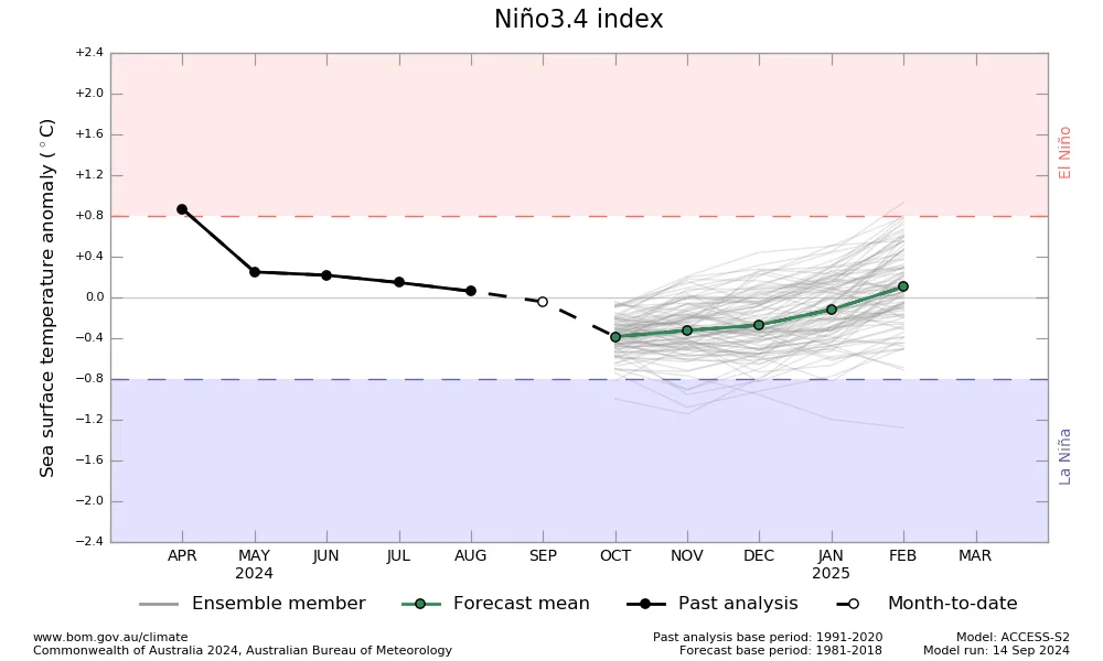
For monitoring experts and those who follow daily numerical physical models, they will notice the obvious decrease in their accuracy in the medium and long-term periods and they will soon recalculate, due to the unusual path of the subtropical jet stream that affects this data, and this weakness has also been observed in the results of multiple probabilities (ensemble), and despite this, the WASM multi-technology W.DMM system works with the developed climate model to reduce the proportion of noise and errors from these models.
This greatly increases the chance of strong and unusual cold waves in the Mediterranean region and the Arabian Peninsula during the upcoming rainy season and the intensity of the rainy season as well in a wide range of the Middle East, Mediterranean, and many Arab countries.
The WASM Regional Center previously issued a forecast for a strong storm in the central Mediterranean in August 2024 update, and indeed this strong storm (Storm Boris) occurred, causing major damage in the Mediterranean region and southern Europe and caused casualties and major material losses.
WASM will issue more studies and seasonal forecasts supported by many detailed maps of unusual atmospheric circulation, and the WASM Regional Center is considered the only Arab center that studies climate changes and their impact and the extent of their changes during the coming period, which has achieved important successes in recent years.
Sources..
http://www.bom.gov.au/climate/enso/#tabs=Overview
https://www.ospo.noaa.gov/products/ocean/sst/anomaly/
http://www.bom.gov.au/climate/enso/#tabs=Southern-Ocean
https://www.cpc.ncep.noaa.gov/products/precip/CWlink/daily_ao_index/aao/aao.shtml
https://iri.columbia.edu/our-expertise/climate/forecasts/enso/current/?enso_tab=enso-sst_table