
WASM - The current rainy season is expected to extend to a late period of spring over Jordan and surrounding countries in the region, with cold weather conditions continuing until mid-spring based on data from the WASM Regional Climate Model Center.
The atmosphere is affected by unusual circulation patterns, which have caused abnormal weather conditions in different parts of the world. This atmospheric circulation has caused a significant increase in rainfall rates in Jordan in recent years, especially over the past 10 years.
A long rainy season|
An early start to the current rainy season was recorded, and many areas exceeded their seasonal averages early and in a rare occurrence at this time of year, based on data from the Jordanian Ministry of Agriculture. The current rainy season is expected to continue until a late period of spring, similar to the previous rainy season, as a result of the unusual atmospheric circulation.
Cold periods continuing until mid-spring|
Cold periods are expected to continue sometimes until mid-spring. The WASM Regional Center expects Jordan to be affected by a very cold period at the beginning of March and during the holy month, with renewal at the end of March in the form of a very late cold wave. This weather pattern has been observed repeatedly in recent years. The rainy season is expected to extend until the end of spring in the region.
The El Niño climate phenomenon|
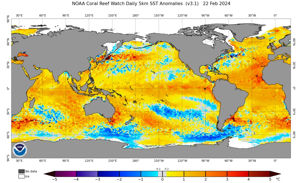
The tropical Pacific Ocean region is recording a significant increase in sea surface temperature, which is called the El Niño climate phenomenon. The El Niño climate phenomenon causes a major impact on atmospheric circulation by primarily affecting the subtropical jet stream. This phenomenon coincided with a significant increase in the temperature of the northeast Pacific Ocean in a rare occurrence. This coincidence caused a significant intensification of the Polar Jet Stream. This effect resulted in delayed snow in many parts of the world and its concentration in specific areas. This also resulted in high rainfall rates in the eastern Mediterranean and Jordan with the continuation of atmospheric depressions on most winter days.
The El Niño climate phenomenon will continue until summer, with expectations of its continuation in a weak manner during the next rainy season.
Analysis of atmospheric circulation|
With the analysis of the main weather patterns, a significant weakening of North Atlantic storm systems and cooling of North Atlantic waters was observed at the end of February at the same time. This was attributed to the beginning of an unexpected weakening of the warm Gulf Stream, which is considered rare and may be caused by significant ice melting in the Arctic region, causing a change in water density. The stoppage of this current could lead to strong and radical sudden climate changes in different parts of the world, resulting in completely new climate conditions.
The weakening of North Atlantic storm systems will cause a high probability of developing "late" winter storms during March and until the beginning of April throughout the Mediterranean region and more clearly in the eastern Mediterranean region.
A strong drought wave will noticeably retreat in the Maghreb region as a result of expected increased activity of Mediterranean storms, especially with expectations of a clear rise in atmospheric pressure in most parts of Europe and a reduction in the intensity of North Atlantic storm systems.
There is also a strong continuation of storms in western United States and California, which will result through the interconnection of main weather patterns in a clear and strong rise in atmospheric pressure over the European continent.
This atmospheric system has caused a surge of very cold air masses from Siberia and the North Atlantic region towards the entire Mediterranean region, causing strong storms concentrated mainly in the eastern Mediterranean region. This means that large quantities of additional rain are expected in the Levant region, Jordan, and which will clearly extend this time towards their desert areas as well as the Arabian Peninsula region.
A weakening of the Polar Jet Stream is expected during the coming period, especially over eastern Europe and also over western United States and the far eastern Atlantic region. This promotes strong storms in the Mediterranean region until a late period, specifically over the eastern Mediterranean.
Flash flood forecasts|
According to climate records, the chance of flash floods usually increases during spring in the region, as a result of the return of baroclinic atmospheric instability cases that weaken significantly during winter. This type of atmospheric instability also occurs during the impact of atmospheric depressions at the same time due to sharp vertical thermal gradients during spring.
Flash flood chances will accelerate during March and reach their peak during April with the continuation of cold air masses arriving and coinciding with active tropical waves in the Arabian Peninsula region and the western Arabian Sea and tropical Africa region.
How do we deal with sharp weather fluctuations?
Sharp weather fluctuations and large amounts of rain that occur at the end of rainy seasons are considered dangerous for many sectors, especially the agricultural sector, which depends on planting summer crops. As a result of the rainy season extending to a late period, we always recommend delaying the planting of these crops in mountainous areas and not rushing. Strong and sharp weather fluctuations often sometimes result in very warm days temporarily, which can be deceiving to many.
Weather bulletins and official warnings issued should be followed continuously, with attention to sudden weather fluctuations during the coming period and spring, which is usually characterized by strength in some cases and rapid and sudden change.