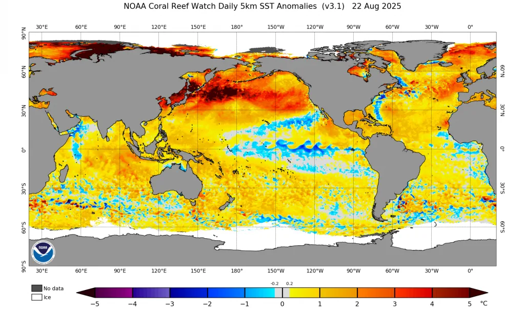
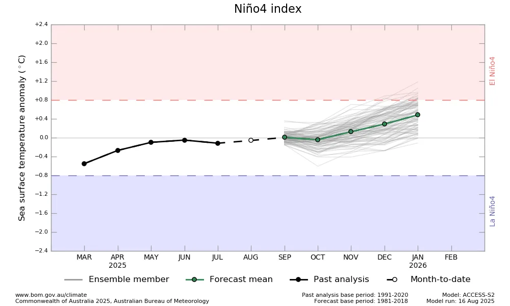
WASM – Neutral conditions are dominating the tropical Pacific Ocean region for the second consecutive year without the ability of the "La Niña" phenomenon to develop successfully. The reason for this returns to complex climatic factors related primarily to the oscillation of trade winds and the disruption of the Southern Annular Mode "SAM", which leads to the development of the "Modoki Niño" phenomenon starting from the end of fall and throughout the beginning and middle of 2026.
The Modoki Niño phenomenon is a "dangerous" climatic phenomenon that leads to a significant increase in the temperature of the western 4.0 region of the tropical Pacific Ocean compared to other areas of the tropical Pacific Ocean. It has severe effects on atmospheric patterns in the North Pacific and plays a major role in changing the intensity of the polar jet stream and the polar vortex.
The failure of La Niña development during the previous year led to unusual atmospheric circulation and variability in rainfall season in the Arab region. Wide areas from south and east of Jordan and parts of its center, west and central Saudi Arabia, and northeast and central-west Iraq recorded heavy rainfall amounts during the 2024-2025 season, while Syria, Lebanon, northern Jordan, Palestine, east and south of Saudi Arabia suffered from low rainfall rates.
This significant variation in rainfall rates was due to an "unusual" weakness of the subtropical jet stream over the eastern Mediterranean, which led to the formation of atmospheric lows south of Cyprus or Egypt (which matches our center's studies), which concentrated rainfall in the southern parts of the Levant, west and north of Saudi Arabia, and its northeast.
The weakness of the subtropical jet stream over the eastern Mediterranean is a "dangerous" climatic phenomenon that began to appear clearly since 2013, which led to a significant increase in rainfall amounts in south of the Levant, Jordan, Palestine, and Saudi Arabia, with the increase exceeding 60%, where 9 strong rainfall seasons were recorded out of 12 previous seasons.
Despite the significant weakness of the subtropical jet stream in the eastern Mediterranean, far western Mediterranean, and eastern Atlantic regions, the polar jet stream remains strong, which continues to weaken the arrival of polar air toward the region, which is reflected in the nature of characteristic weather conditions in the region.
Stagnation and Neutral Conditions in the Tropical Pacific Continue for the Second Year|
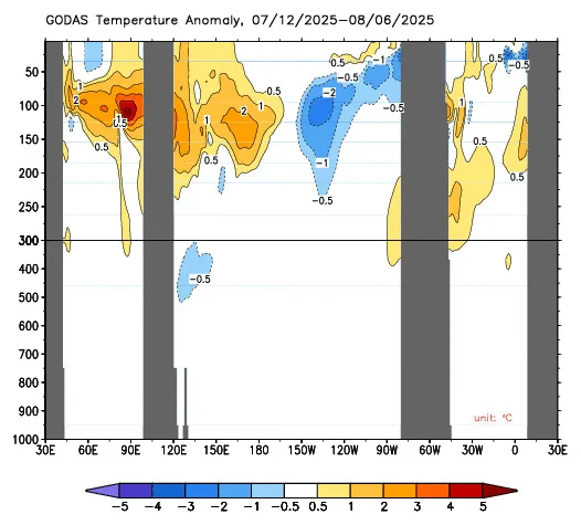
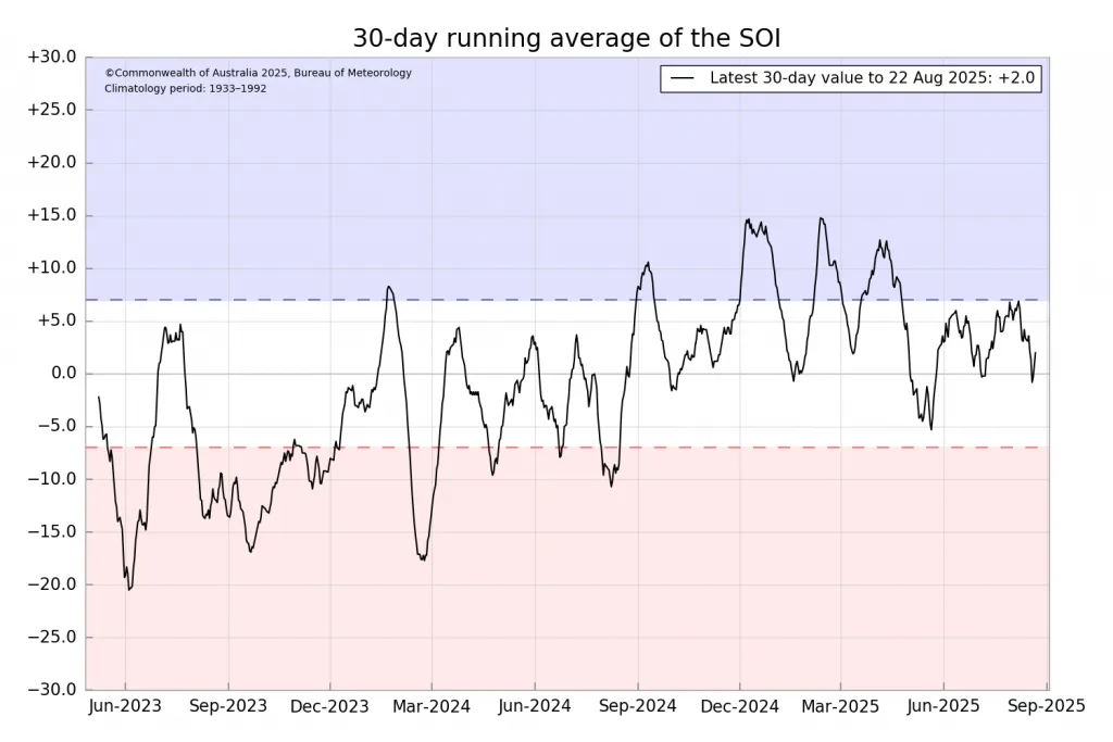
High ocean temperatures, the dominance of marine heat waves, the oscillation of trade wind movement in the tropical region, and the accumulation of shallow and deep subsurface warm waters in the tropical Pacific Ocean region continue to hinder the development of La Niña, which leads to a major impact on atmospheric circulation.
This failure in La Niña development coincided with a slow beginning of "Atlantic La Niña" development, which is primarily responsible for cooling the Atlantic region and meanders of the polar jet stream later, warming the European continent, and cooling Mediterranean areas later, which may expose eastern and parts of central Mediterranean areas to strong storms during the second half of the upcoming rainfall season.
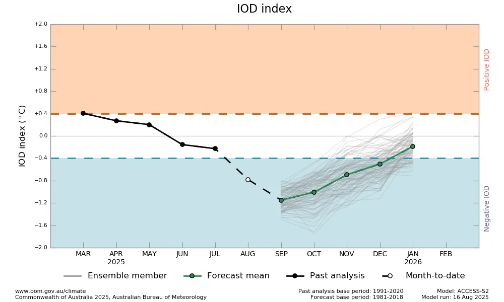
With the expectation of the beginning of temperature increase in the western part of the Pacific Ocean due to the decrease in temperature of the eastern region of the tropical Indian Ocean at the end of fall, there is a "major" expectation of temperature rise in the western region of Niño 4.0 leading to the nucleus of the Modoki Niño phenomenon, which is the most dangerous to atmospheric circulation, especially during 2026, and which may play a major role in the temperature of the northeast Pacific region, leading to severe weakening of the polar jet stream and its "major" meanders and perhaps the largest in many years.
The increase in the rate of heat waves in the European continent and their significant decline in the eastern Mediterranean is due to the change in the movement of jet currents. The upcoming climatic changes that are "very dangerous" will be in the form of heavy rainfall weather conditions in the Middle East region, especially Jordan, Palestine, Egypt, Iraq, west and north of Saudi Arabia and northeast, reaching Kuwait, with irregular effects toward the southeast of the Arabian Peninsula, the UAE, and Oman.
Therefore, we advise caution against unscientific reports or studies borrowed from abroad that focus on local conditions in Europe rather than in the Middle East region. Those scientific and accurate studies are designated for European regions and should not be cited and applied to our Arab regions because our regions have a climate completely different from Europe.
WASM Regional Center will issue detailed reports on the Modoki Niño phenomenon and forecasts for the upcoming rainfall season using our climate model and simplified videos explaining these phenomena in a scientifically accurate manner.