
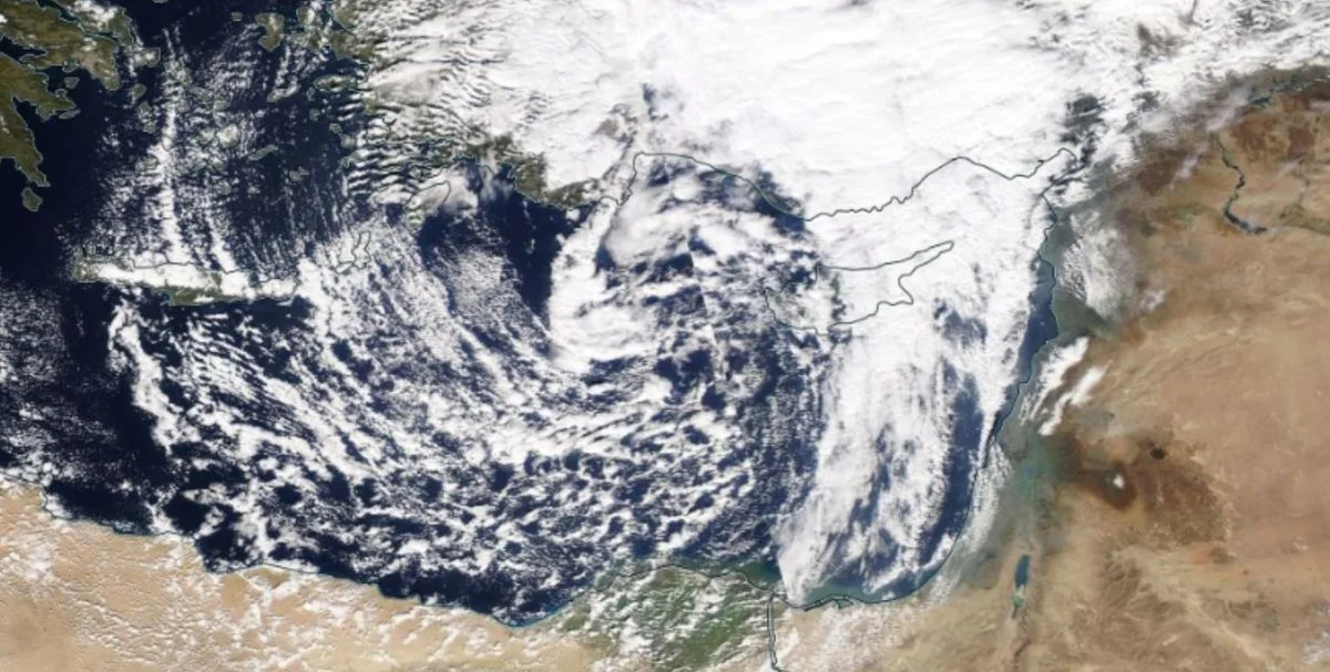
WASM- The WASM Regional Center is monitoring an extremely high and intense rainy season expected during the upcoming season, which is anticipated to start early and end late in the spring with temperatures below seasonal averages for prolonged periods during the rainy season, as a result of unusual atmospheric circulation patterns affecting the atmosphere.
The Middle East region, including Saudi Arabia, Gulf Arab countries, Jordan, and most of the region, is experiencing severe climate changes that have caused a very significant increase in rainfall rates and a rise in flood and torrent cases, with rainy seasons extending for unusually long periods and occurrence of unseasonal heavy rainfall. This is due to the intensification of these climate change effects resulting from unusual atmospheric circulation patterns. Conversely, many areas of southern and central Europe and North Africa are experiencing very hot and dry periods with a sharp decline in rainfall rates.
Most Middle East regions have recorded a significant increase in rainfall rates exceeding 60%, due to the unusual atmospheric circulation patterns that cause cold air masses from northern and northeastern Europe to surge toward the Eastern Mediterranean basin region, resulting in continuous successive heavy and intense rainy conditions that are unusual, and an increase in the extremity of various weather conditions.
Results of the Center's Climate Model..
The latest results from the center's climate model, which was run on September 23 and 27 respectively, showed the occurrence of extreme climate conditions expected over the region during the period of October-November-December-January 2023-2024, as well as an extension of the rainy season to a late period in spring, and an early onset of the cold winter season is expected to be recorded in the region.
Unusual Atmospheric Circulation..
Data received by the center shows unusual atmospheric circulation causing a sharp weakening of the subtropical jet stream (which blows at high altitudes reaching 40,000 feet). This current blows between cold and warm air masses, and when its strength weakens, this indicates that cold masses are reaching the region easily, causing atmospheric instability and the formation of strong Mediterranean low-pressure systems.
A rise in Mediterranean Sea temperature was observed as a result of the strong heat waves that struck southern Europe and the western and central Mediterranean regions during the summer, and due to water circulation in the Mediterranean Sea, this caused a significant increase in Eastern Mediterranean temperatures, especially at the end of summer, which causes increased activity in the formation of Mediterranean low-pressure systems in the region and a very significant increase in rainfall rates.
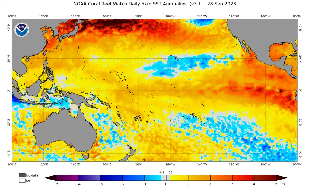
The El Niño climate phenomenon caused a climate emergency event in the western Indian Ocean region, where temperatures rose significantly in the western Indian Ocean, shifting tropical activity toward Somalia and southern Arabian Peninsula. This causes excess dynamical activity in the energy exchange between tropical and subtropical regions in the area, resulting in a strong high-pressure system in North Africa and central Europe and large amounts of moisture in the Arabian Peninsula, Middle East, and northeastern Africa regions.
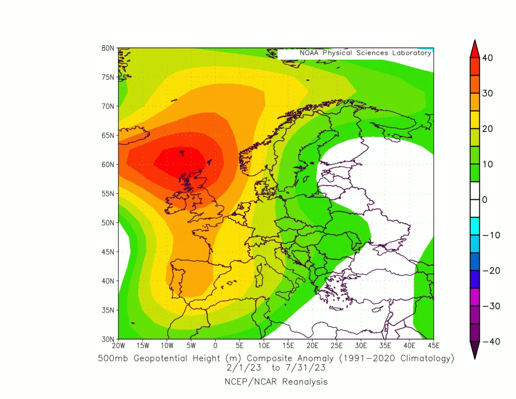
The climate emergency events that occurred in spring 2023 and intensified during summer and fall will cause a significant increase in the extremity of climate events and weather conditions in the region, particularly regarding sudden flooding and torrents, strong cold waves, and heavy rainfall, as well as temperature drops below seasonal averages during winter by several degrees compared to previous years. Climate change events vary from one region to another and should not be assumed to match what occurs in Europe as found in some Arab climate studies. The impact of climate changes is complex and interconnected and varies from one region to another, with Jordan recording a significant increase in rainfall rates over the past 9 years exceeding 60% in some areas.
.
Severe dry waves over the Maghreb and southern and central Europe..
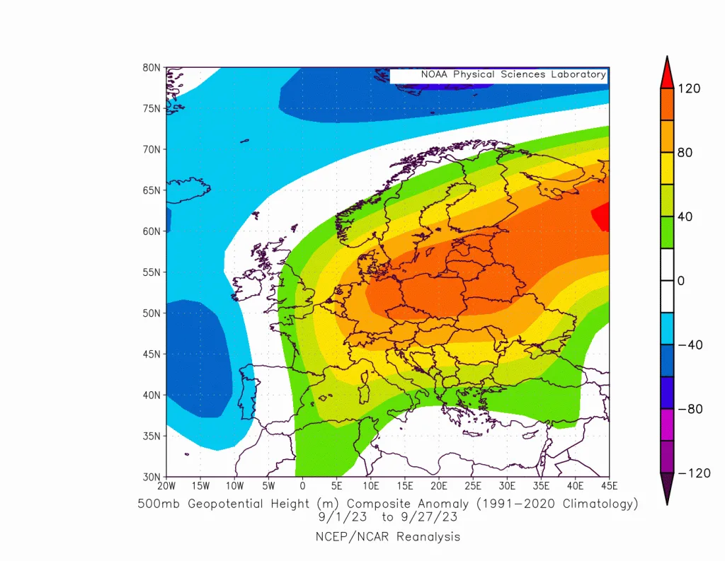
Dry waves are expected to intensify over the Maghreb region, southern and central Europe, due to the expected coincidence of Atlantic storms which draw their strength from the effect of rising water temperatures in the North Atlantic with the presence of a strong high-pressure system in central and southern Europe and North Africa. This atmospheric system will cause a significant increase in temperatures and the continuation of delayed heat waves during fall over those areas, contributing to the continued warming of the Mediterranean region. The warming of the Mediterranean Sea coinciding with the surge of cold masses toward its east will cause extreme weather conditions resulting from this unusual atmospheric circulation pattern.
Data from the WASM Regional Center's climate model shows this high-pressure system moving slightly toward northeastern Europe during winter, allowing Atlantic storms to surge and affect the British Isles, extreme northwestern Germany, and western Scandinavian islands. This sometimes causes severe weakening of the jet stream in extreme southwestern Europe and Morocco, allowing for regional rainy conditions over those areas. This causes the confinement of very cold Siberian winds toward the Eastern Mediterranean basin and an increase in the flow of warm, moist air masses from the Arabian Sea region toward the Arabian Peninsula, Jordan, and Middle East countries, resulting in more extreme weather situations and possibly an early development of winter storms surging from the Eastern Mediterranean during December.
.
El Niño Climate Phenomenon..
This phenomenon is considered a heavy guest on the climate conditions occurring in the atmosphere, which will cause a significant increase in its extremity. This phenomenon will coincide with extreme weather patterns over many regions of the world, particularly western United States, northwestern Europe, southeastern Europe, and the Eastern Mediterranean and Arabian Peninsula, as well as vast parts of northeastern Asia.
The El Niño climate phenomenon causes a significant impact on the jet stream trajectory, which is considered the main steering mechanism for atmospheric system movements and the nature of their dynamic activity in many regions, and a direct effect on the "Hadley Cell," one of the basic pillars of atmospheric circulation that causes the discharge of large energy from tropical activity toward subtropical latitudes. This causes the strengthening of this jet stream in some regions and its weakening and retreat in others, and we may observe the concentration of atmospheric wave patterns for long periods over specific regions during fall and winter.
Atmospheric Circulation During the End of the Rainy Season..
This effect will be observed during mid-winter, following high atmospheric activity in an attempt to rebalance atmospheric systems in many regions and with the decline of the El Niño climate phenomenon. However, the WASM Regional Center, through results of the climate model it has developed, expects the occurrence of extremely severe climate and weather conditions in various regions of the world, not just in specific regions. Rapid transitions will occur between Rossby waves between different areas of the European continent as well as between western and eastern Mediterranean, causing strong and sudden storms which will be evident during the second half of January until late spring.
This effect will be observed in severe temperature fluctuations, sharp differences in the region, rapid, powerful, and sudden severe weather swings, which means the necessity of activating early warning systems for strong and emergency weather conditions that may be sudden and unexpected in some areas.
The WASM Regional Center will issue the seasonal bulletin to the media and public after issuing it through internal channels to benefiting agencies, and climate model general data will be made available for free and continuously. The center will also work on developing the climate model and providing its graphical outputs for free to all interested parties and beneficiaries.