
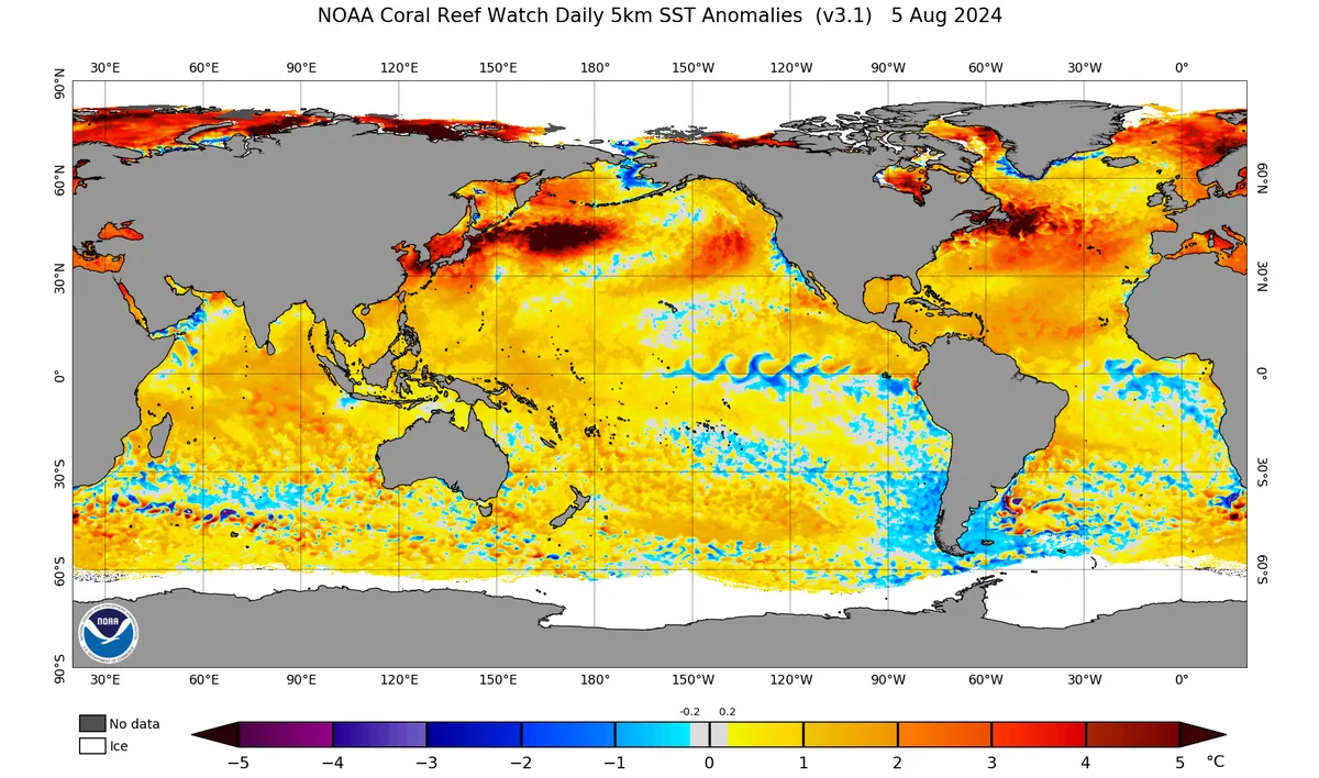
WASM – The WASM Regional Center continues to monitor a sustained cooling decline in the tropical Pacific Ocean region with a clear and noticeable weakening in trade wind speeds in those areas, resulting from several climatic factors that have weakened this important and anticipated phenomenon, which contributes significantly to mitigating heat in subtropical latitudes.
Introduction..
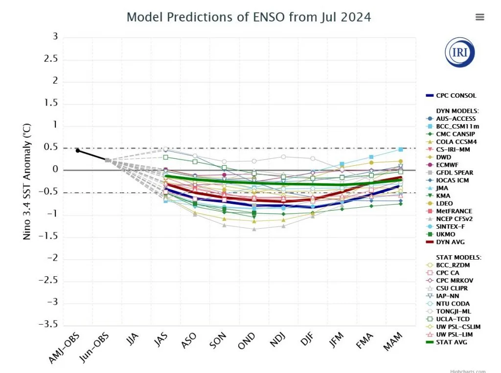
The American models, most notably those from NOAA, issued important data on the development of a "strong" La Niña phenomenon in the tropical Pacific Ocean region with mid and late summer, however these results have not been accurate so far, contrary to the Australian ACCESS model and the European long-range ECMWF model, as well as the results of statistical models, which predicted a neutral cold phenomenon to weak La Niña at best.
It appears that climate model data during summer usually suffers from reduced accuracy, which the WASM Regional Center treats with utmost caution, and since the climate model of the WASM Regional Center relies on calibrated similarity periods based on weather data issued from climate models specialized in major climatic factors, the results during the upcoming rainy season depend greatly on changes in this data, which reflect circulation patterns that differ significantly in the atmosphere.
Non-development of the La Niña phenomenon does not necessarily mean continued high heat..
Due to anticipation of this phenomenon that helps reduce atmospheric heat, especially in subtropical latitudes that are affected by the major tropical activity caused by the El Niño phenomenon, but this is not everything, as the activity of the polar jet stream during the previous season, which caused a weakening in thermal circulation (or the process of thermal balance in the atmosphere), was the main cause of rising heat in mid and subtropical latitudes and the absence of snowstorms from many regions of the world.
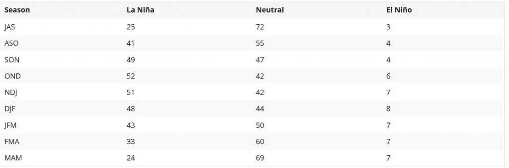
Cold neutral phenomenon reduces (relatively) tropical activity in subtropical latitudes..
Even if slowly compared to the strong La Niña phenomenon that greatly weakens tropical activity over most of the tropical Pacific region and confines it above northern Australia, the cold neutral phenomenon helps, albeit more slowly, reduce heat in the subtropical region.
Cooling expected in the upcoming season due to factors related to polar circulation..
A clear decline is expected in the intensity of the polar jet stream, its weakening, and its continuous undulation, which started from western Canada and Alaska and has begun to appear clearly over the eastern Atlantic Ocean region and the European continent. This pattern will help in a large thermal exchange process between subtropical and polar latitudes, passing through mid-latitudes, which reflects a high probability of increasing the number of mid-latitude storms, including Mediterranean storms and baroclonic-mid-latitude weather systems, causing long periods of drought on the European continent and Central America, a stormy winter season in the Mediterranean region, southern and eastern United States, and east Asia.
The reasons that caused the weakening of the La Niña phenomenon..
The scientific reasons that caused the weakening of the La Niña phenomenon are multiple. First are the sharp polar undulations in the southern part of the Earth, due to a significant weakening that occurred in the polar jet stream as well, which resulted in the transport of strong cold waves toward Australia and mid-latitudes. This sharp negative Southern Annular Mode (SAM) greatly affects the development of the La Niña phenomenon in general according to old climate data and studies issued by Australian meteorological agencies, due to its coincidence with the activity of strong westerlies in southern subtropical latitudes.
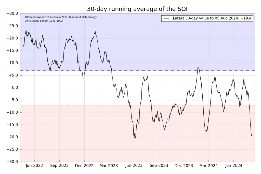
This also coincided with a clear and noticeable weakening in trade winds as well in the tropical Pacific Ocean region, which caused a weakening in the development of this phenomenon, reflecting the superiority of the European and Australian models in detecting this compared to the American models that were extreme in predicting a strong La Niña phenomenon.
Due to the weakness of warm subsurface waters and their absence as well, or weak impact on water circulation, and perhaps even due to the sharp and significant warming of the northern Pacific Ocean surrounding the tropical Pacific region, this resulted in a decline in the probability of La Niña development from 75% to 50% by late summer and early fall. With data analysis and filtering of data that causes noise resulting from long-range American models, we do not expect the percentage to exceed more than 40-30% only for strong La Niña development.
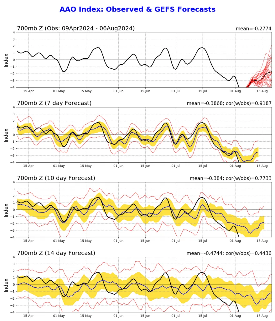
Therefore, due to several climatic factors that appeared suddenly, which relate to a sudden and strange weakening appearing in the polar jet stream in both the southern and northern hemisphere, which is expected to continue at least until the end of spring in 2025.
Non-development of the La Niña phenomenon or its development in a weak and limited form for a short period will show very different results in atmospheric circulation, which relate to strong circulation over the northern and eastern Atlantic Ocean region and long and unusual dry periods in Central Europe separated by short periods of strong storms.
The results are also linked to Atlantic La Niña or cooling of the tropical Atlantic Ocean region, which rapidly reflected a clear weakening in the subtropical jet stream over the eastern Atlantic and responsible for the succession of strong heat waves toward Europe and the moderation of summer in the central and eastern Mediterranean region and northern Saudi Arabia and high rainfall rates in southwestern and southern Saudi Arabia.
Possible weather phenomena..
The collapse of the La Niña phenomenon before the start of its development due to several major climatic factors that occurred suddenly, most importantly the sharp negative Southern Annular Mode (SAM), caused important expected changes in weather conditions in the mid-latitude region, specifically in the Mediterranean region, where this greatly increases a stormy and cold winter in many periods with ease of access of cold polar air toward the Mediterranean.
The weakening of the polar jet stream, which coincides with the weakening of the subtropical jet stream in the eastern Atlantic Ocean region, will cause completely different results on weather conditions that will occur in the Mediterranean, which suffers from high and unprecedented surface water temperatures in recent climate records. High temperatures of water bodies, especially in mid to lower latitudes, are not sufficient alone to develop strong storms, as dynamic factors remain more important, especially since they are naturally baroclonic weather systems even if they are semi-tropical storms, as the first spark remains baroclonic and not barotropic.
The areas most affected by strong weather conditions during the upcoming season will be in the central and eastern Mediterranean region in the first place, and the axis of the Mediterranean front will be clearly tilted toward northern Libya, eastern Tunisia, reaching Greece and even northern Egypt and then the Levant region, Jordan, and Palestine, causing strong weather conditions also in western and northern Saudi Arabia and even Iraq in many periods, especially with the middle of fall, as the Mediterranean front will tilt more toward the east with the intensification of Atlantic storms until the coasts of western Europe.
What will distinguish the upcoming winter season is temperatures lower than usual during December-January-February in the region, especially in the central and eastern Mediterranean, northern Saudi Arabia, Iraq, and Egypt. This may sometimes coincide with short warm periods depending on the axis of the Mediterranean front, which may sometimes tilt toward the central Mediterranean.
Mediterranean depressions, especially Cyprus and Egyptian lows, are extremely important for unstable weather conditions in the Arabian Peninsula, and based on the axis of the Siberian high-pressure system that will tilt more toward the east compared to typical La Niña years or seasons following strong El Niño years, this will cause the development of a strong moisture channel toward Saudi Arabia, especially its western and central regions, during the upcoming rainy season, which is not unlikely to cause record rainfall amounts in some periods unprecedented in recent climate records.
Strong rainy seasons that affect the Levant are continuing and expected again this season, and there is no truth to any report suggesting a decline in rainfall levels in Jordan, Palestine, or any region in the Middle East, as these are weak studies lacking all scientific basis, and the WASM Regional Center has denied them on more than one occasion.
The continuity of high rainfall rates in the region during the upcoming season may be an indicator of a long wet climate cycle or an important climate change beginning to affect the region, knowing that natural climate changes resulting from several natural conditions affecting planet Earth, including geological factors or changes in the rotational movement of ocean currents, cause weather and climatic conditions that vary greatly and may sometimes be surprising.
Sources..
https://iri.columbia.edu/our-expertise/climate/forecasts/enso/current/?enso_tab=enso-sst_table
https://coralreefwatch.noaa.gov/product/5km/
http://www.bom.gov.au/climate/enso/#tabs=Pacific-Ocean&pacific=Forecast