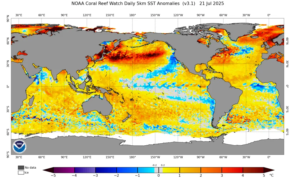
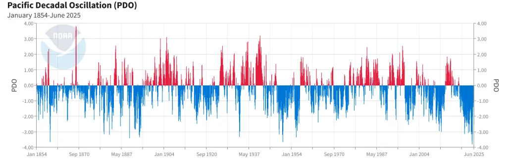
WASM – The Pacific Decadal Oscillation "PDO" recorded the lowest value in the history of modern climate records during the last winter of 2025, which reached -3.80, breaking the previous record set in 1950 which reached -3.65 according to data from the American National Oceanic and Atmospheric Administration "NOAA". This climate factor affects atmospheric circulation "very significantly," which WASM Regional Center considers the most influential climate factor during the previous 2024-2025 season as well as the 2023-2024 season.
What is this climate factor?
The Pacific Decadal Oscillation PDO or The Pacific Decadal Oscillation measures the extent of fluctuation in surface temperature of the North Pacific Ocean region, which is the thermal oscillation between the waters of the central North Pacific and the coasts of Canada and the coasts of western North America.
This oscillation is considered negative when there are cold waters along the coasts of western North America compared to warm waters in the central North Pacific (as is currently the case), and vice versa. The change in this factor is slow and may take more than 20 years to transition from the negative phase to the positive phase and vice versa.
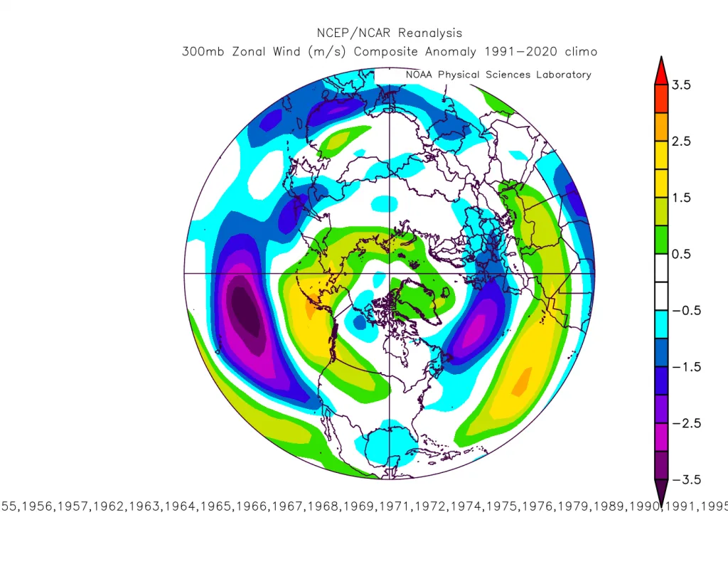
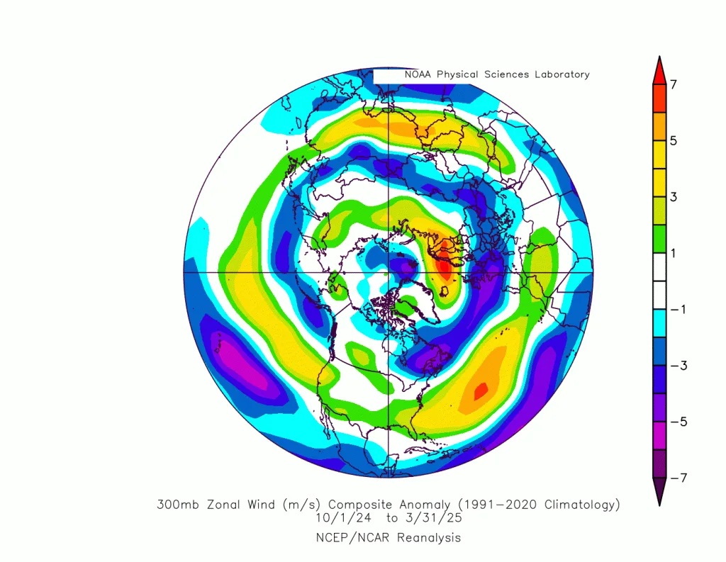
This climate factor entered the negative phase since mid-1998 and reached the peak of its severity and strength since 2021. This factor does not affect the atmosphere by itself, but has a strong influence on the Polar Jet Stream, especially over the North Pacific region and even the United States, making it more powerful. Data at the 300 millibar level of the upper layers of the atmosphere was processed to measure the severity of the polar jet stream in years that recorded negative PDO values for the region.
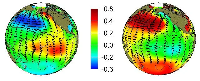
El Niño and La Niña phenomena and their relationship to this factor|
Long negative or positive periods do not mean they are completely fixed; rather, there is a clear and significant oscillation during changes in ENSO phenomena, which play a major role in influencing the PDO factor. During El Niño phenomena, the positive probability of this coefficient increases and vice versa, due to the clear impact on tropical and subtropical circulation in the Pacific Ocean region and the direct and strong impact on the subtropical jet stream, which leads to strong effects on atmospheric patterns in the North Pacific region and then affects wind movement along the coasts of North America.
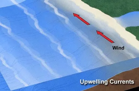
A change in wind direction from northerly to southerly along those coasts affects the extent of water flow movement from the depths or vice versa as a result of the strong effect of the Coriolis force and the effect of the "Ekman Force" due to winds that friction against sea and ocean waters near the coasts.
Despite the impact of these phenomena on the PDO coefficient, WASM Regional Center issued a "very important" study on the impact of Modoki El Niño phenomena with greater strength on this factor, which reflects a very severe impact on the atmosphere.
Negativity of the PDO coefficient and the results of its impact|
Extracting direct results from this coefficient is "extremely complex," but the severe negativity of this coefficient during the last season and the calm of the tropical Pacific Ocean region gave us a very clear picture of a significant strengthening of the polar jet stream around the poles. Due to the strength of the El Niño phenomenon during the 2023-2024 season, which resulted in enormous dynamic warming toward subtropical and mid-latitudes, resulting from the large tropical activity that released enormous thermal energy, this caused a very warm winter in most regions of the Northern Hemisphere with a strong polar jet stream recorded.
It is rare for a strong El Niño phenomenon to coincide with severe negativity of the PDO coefficient as happened in the 2023-2024 season, but it appears that this climate factor is dominating the polar region strongly in recent years. However, there are major climate shifts expected during the 2025-2026 season that may lead to a major and sudden weakening of the polar jet stream, leading to temporary global cold waves that will somewhat ease the intensity of elevated temperature levels, and this is what we will explain in this report.
A positive shift to this climate factor and in an "accelerated" manner during the coming season|
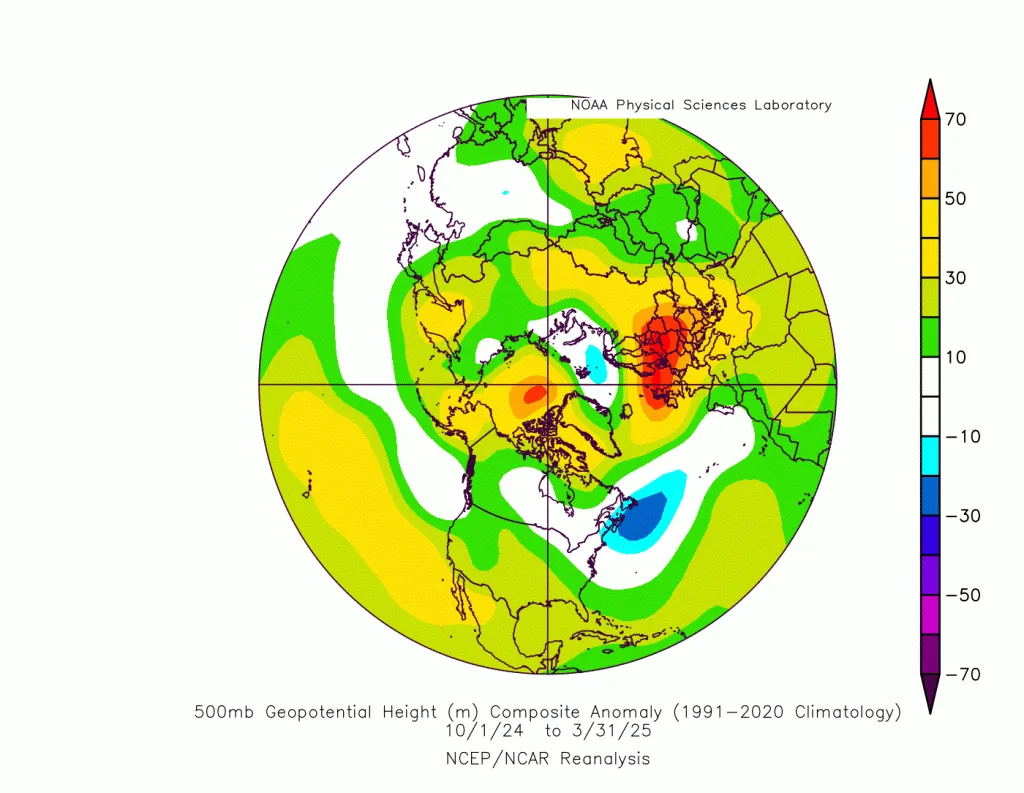
Looking at the reprocessed atmospheric maps shows a strong polar jet stream over northwest Europe resulting from the warming of the North Pacific and strengthened by the North Atlantic region.
A decrease in tropical heat in the Atlantic Ocean region will threaten a major weakening of the subtropical jet stream in the Mediterranean Sea and eastern Atlantic regions and a clear weakening of Atlantic storms, which is also reinforced by the decrease in heat in the North Atlantic.
The PDO climate coefficient retreating rapidly and starting from the end of the coming fall and the beginning of winter will greatly enhance the likelihood of "a sudden collapse of the polar jet stream." This phenomenon may generate "severe" polar waves, especially in southern and western United States, central and eastern Mediterranean, northern Arabian Peninsula, and southern Europe in general.
Therefore, according to current data, the likelihood of severe cold waves during the coming season in the Middle East region is "high," which is expected to be more humid.
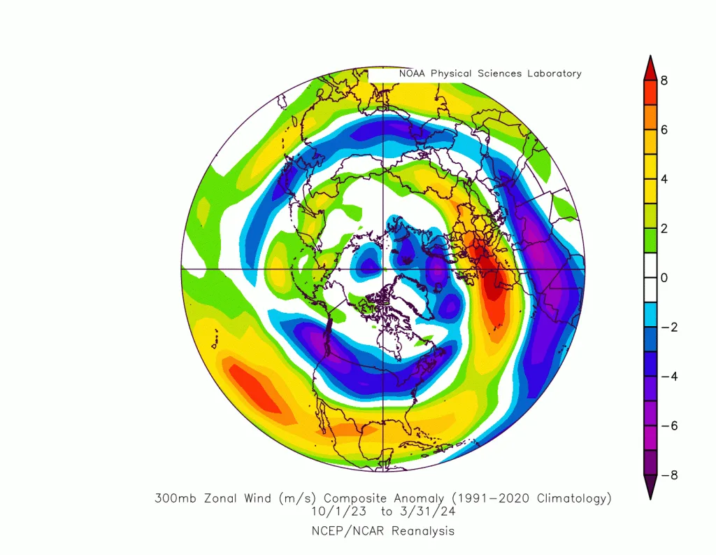
During the 2024-2025 season, several cold waves were observed but they were dry, as several periods of minor and temporary weakness in the polar jet stream were recorded, possibly due to the tropical Atlantic Ocean region cooling temporarily or due to the continuous succession of Atlantic storms. These cold waves did not succeed in forming polar storms toward the lower mid-latitudes and the Mediterranean due to the strength of the polar jet stream in general, and what reinforced these cold waves was a major weakening of the subtropical jet stream.
The subtropical jet stream will remain weak|
The data processed in our climate model at WASM Regional Center clearly showed weakness of the subtropical jet stream in several sensitive areas in North Africa, the Mediterranean, and eastern Atlantic regions, concentrated around Spain and western Mediterranean clearly, as well as the eastern Mediterranean region, northern Saudi Arabia, and Egypt. The results of weakening the polar jet stream in parallel will lead to deepening polar winds down to subtropical latitudes in the Arabian Peninsula region repeatedly during the second half of the rainy season.
Oscillation between the lowest value to positive values|
The oscillation between the lowest value to positive values over 6 months will cause a strong reaction in atmospheric circulation. What is now appearing in atmospheric circulation resulting only from the weakness of the subtropical jet stream near the Mediterranean for several reasons related primarily to a decrease in heat in parts of the Atlantic Ocean regions, especially its tropical parts, reinforced by the warming of western Mediterranean.
With the beginning of the fall season and the beginning of weakening the polar jet stream (the results of which have started to appear near the Scandinavian islands this summer), it will lead to strong global cold waves in the Northern Hemisphere concentrated primarily in central and eastern Mediterranean areas, the Arabian Peninsula, and southeastern Europe, as well as southern and southwestern United States, and also eastern Asia regions, leading to extremely extreme circulation in the atmosphere.
Conclusion|
Despite the scientific complexity of this report due to its depth in studying atmospheric circulation and its impact from ocean heat primarily and its connection to jet streams in the upper layers, and with the use of data from the climate model of WASM Regional Center, which calibrates climate data for different climate factors flexibly through similar periods, the following was concluded|
- Forecasts of a shift in the PDO climate factor from a very low negative value to a positive value in an accelerated manner during the end of the coming fall and beginning of winter.
- A major collapse in the polar jet stream, especially in southern United States regions, eastern Europe, and its southeast, and central and eastern Mediterranean region and northern Arabian Peninsula.
- Leading to exposure of these regions to global cold waves concentrated primarily on southern and southwestern United States, southern Europe and its southeast and east, and Arabian Peninsula and eastern and central Mediterranean and eastern Asia.
- The impact of the PDO climate factor is extremely complex on atmospheric circulation but is directly linked to the activity of the polar jet stream and somewhat similar to the effect of the AMO region on this stream.
- Continuous cooling in the tropical Atlantic Ocean region and warming of western Mediterranean will lead to enhancement of these changes and phenomena in central and eastern Mediterranean region and the Arabian Peninsula.
WASM Regional Center will run the climate model in a main cycle during the second week of August again to show more accurate results about the nature of the rainy season in various regions of the world.
WASM Regional Center notes that climate changes in the last 10 years have caused a significant increase in precipitation rates in the southeastern Mediterranean region, Jordan, Palestine, and north and west Saudi Arabia by a percentage exceeding 40-60%, which is an unprecedented ratio in modern climate records. These expected changes in climate factors will lead to strengthening these climate changes and forecasts of rainy seasons that may be unprecedented in the region during the next 5 years.
This study issued by WASM Regional Center is exclusive and relies on data from its developed and most accurate climate model in the region, which also aims to serve communities, especially Arab ones, in light of the absence of accurate weather information and the lack of climate studies to properly deal with climate changes as well as understand these changes correctly and accurately, which greatly affect dealing with new weather and climate conditions.