
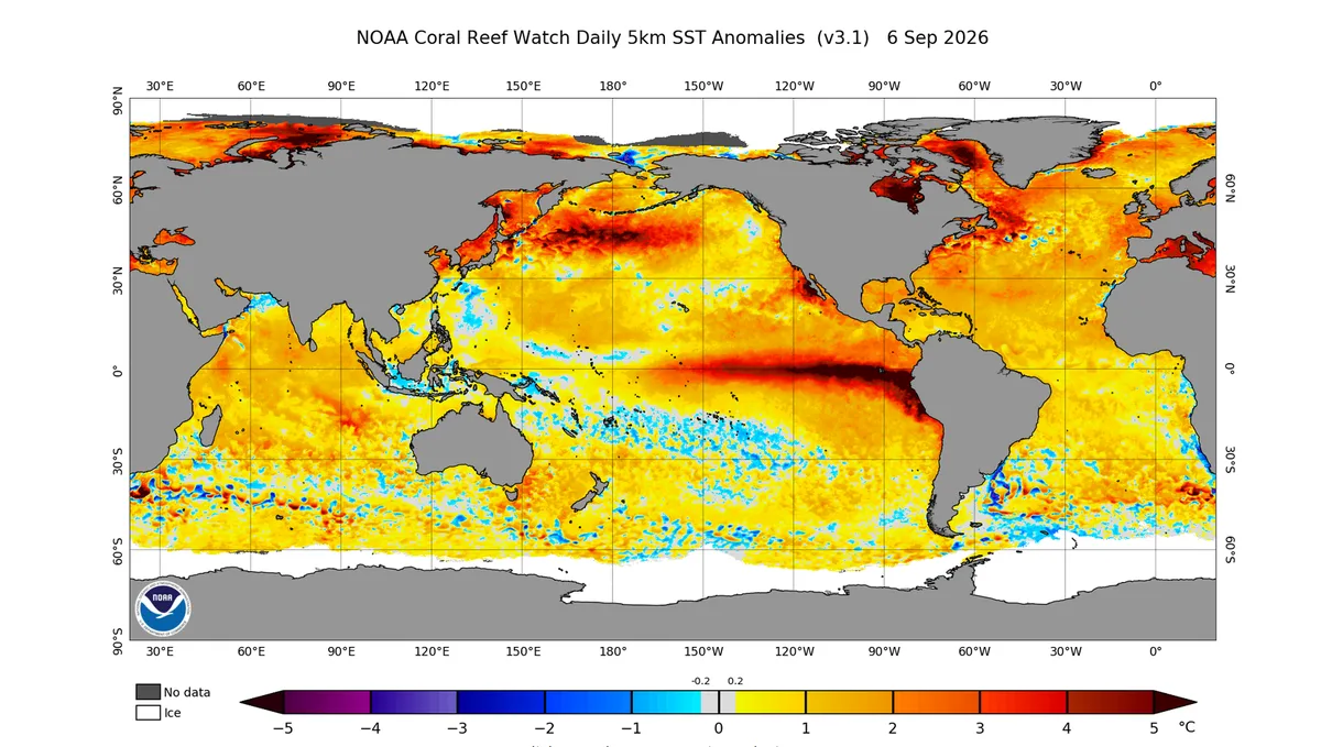
The global climate is expected to be affected in the coming months by the strongest El Niño phenomenon in modern history, which has recently recorded unprecedented values, threatening the world’s climate with more extreme weather conditions.
El Niño refers to an increase in average sea‑surface temperatures across the equatorial Pacific Ocean. Its major impact on atmospheric circulation stems from the intensification and alteration of tropical circulation over the Pacific, which then directly influences weather systems in those regions. As a result, it can trigger floods, droughts, heatwaves, cold spells, and other extreme weather events across different parts of the world.
This significant disruption to atmospheric systems over the largest ocean on Earth—covering 32% of the planet’s surface—leads to severe impacts on atmospheric patterns globally. It directly affects the Hadley Cell, one of the most important circulation cells in the atmosphere, which in turn influences the path of the subtropical jet stream responsible for steering weather systems and distributing them around the globe.
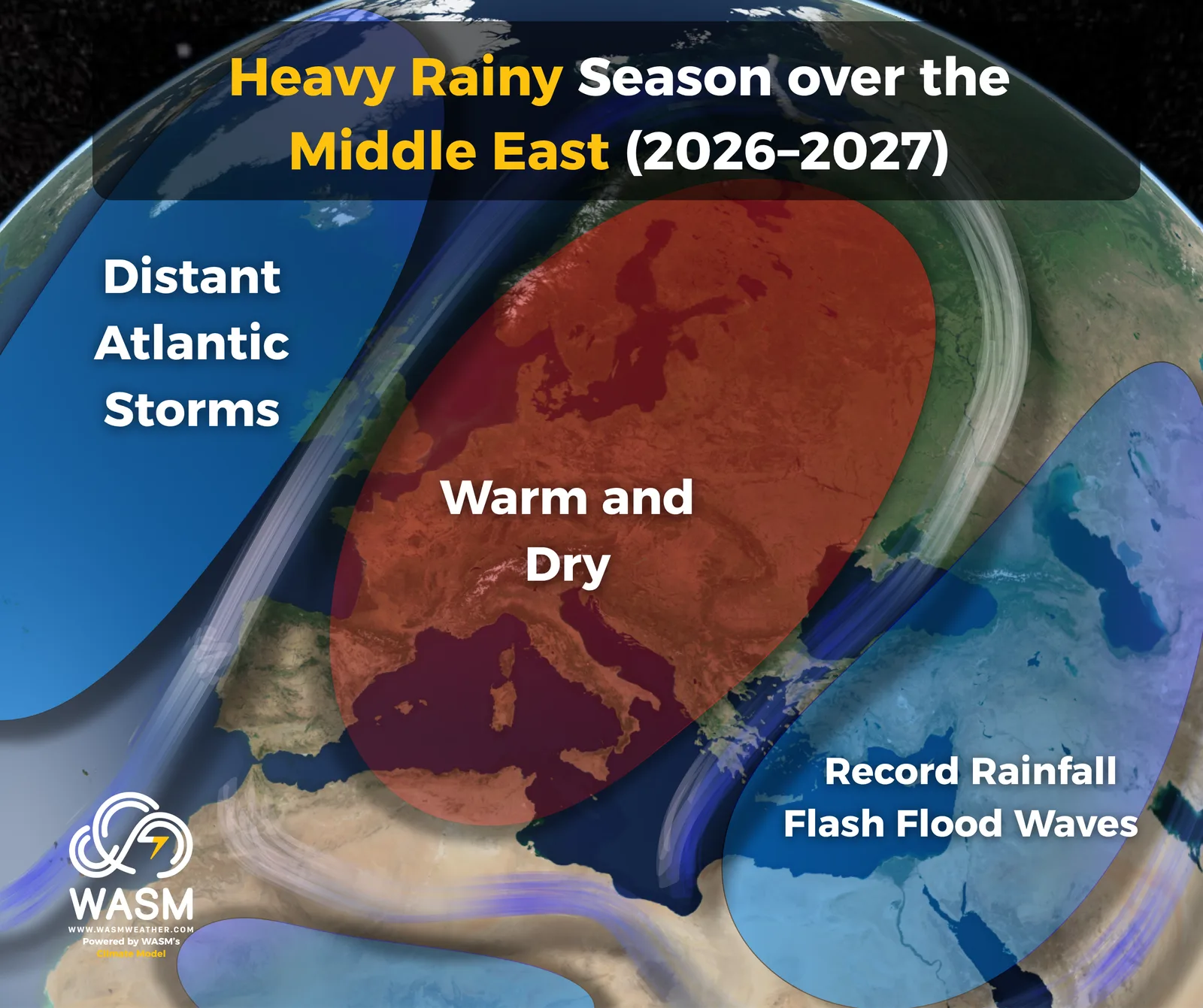
The Impact of El Niño Combined with Other Climate Factors According to the Results of Our Regional Climate Model at Wasm Center
Record‑Breaking Numbers
El Niño regions have recorded historic values, exceeding 4.6°C above seasonal averages in Region 1+2 near the coasts of Peru. This is the highest value ever documented in modern climate records, surpassing the famous El Niño events of 1997–1998 and 1982–1983, signaling globally extreme weather conditions ahead.
The eastern regions have also recorded more than 3.5°C above average, the highest in modern records, meaning the eastern equatorial Pacific has reached its warmest levels in modern history.
Region 3.4—the central and most critical zone—continues to show rapid warming and is expected to reach peak levels by late autumn and early winter, classifying this El Niño as the strongest in modern history.
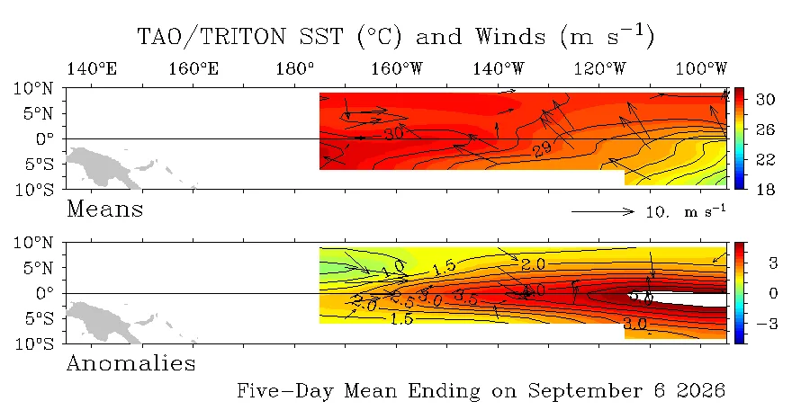
The El Niño phenomenon is recording extreme and unprecedented values in the eastern part of the Pacific Ocean, reaching in some areas more than +5.0°C above the seasonal average.
Atmospheric Impacts
The impacts of strong El Niño events on atmospheric circulation are generally similar, though they vary depending on other climate factors—particularly the Indian Ocean, which currently shows an unusually weak positive phase. This contributes to different atmospheric outcomes, resulting in more extreme weather across the northern Arabian Peninsula, the Levant, Iraq, and the eastern Mediterranean, especially in terms of heavy rainfall and colder‑than‑normal winter temperatures.
Long periods of drought are expected across large parts of the Maghreb, central Europe, parts of western Europe, and northern areas of the United States. Meanwhile, severe flooding and heavy rainfall are anticipated across the southern U.S., including California, Texas, and Florida.
Drought conditions are not expected to be extremely severe in Southeast Asia and Indonesia due to the slightly positive Indian Ocean Dipole, which is forecast to turn negative during winter—potentially triggering more extreme weather in some regions and enhancing the activity of tropical Rossby waves toward the Arabian Sea.
Duration of El Niño
The strong El Niño is expected to gradually weaken during the upcoming spring, though its intense atmospheric impacts will persist for several additional months—manifesting as floods, droughts, powerful storms, and heatwaves.
There are also indications that El Niño may redevelop later next year in the form of El Niño Modoki, due to the unusually warm deep and subsurface waters of the Pacific Ocean. This would produce outcomes that are difficult to predict and cannot rely solely on statistical patterns. Additionally, the expected negative phase of the Indian Ocean Dipole during the second half of the upcoming rainy season increases the likelihood of such a scenario.
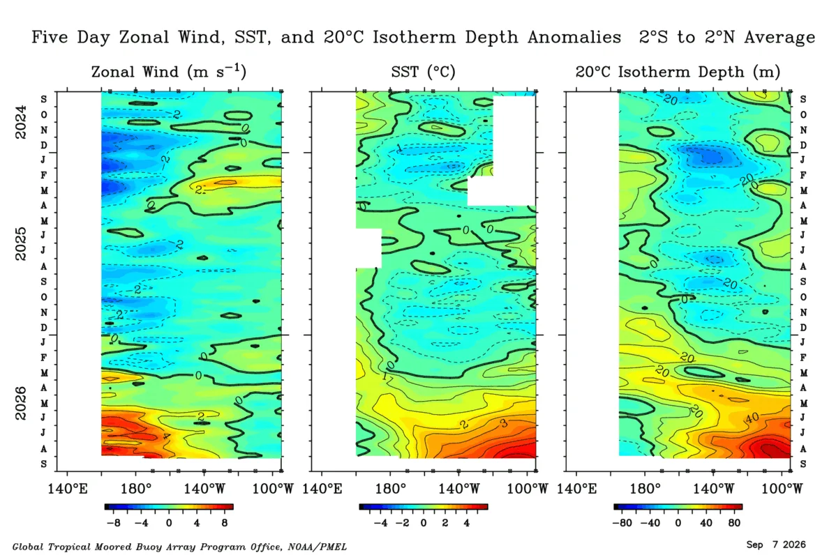
This map indicates a significant intensification of westerly winds over the western Pacific (the strong westerly wind anomalies) — shown on the left side of the map — followed by a substantial rise above the seasonal average (center of the map), and then the presence of highly elevated ocean temperatures extending down to a depth of 80 meters. This deep warming strongly reinforces the strength of the El Niño phenomenon in the coming months and represents a major risk due to its powerful influence on the atmosphere.