
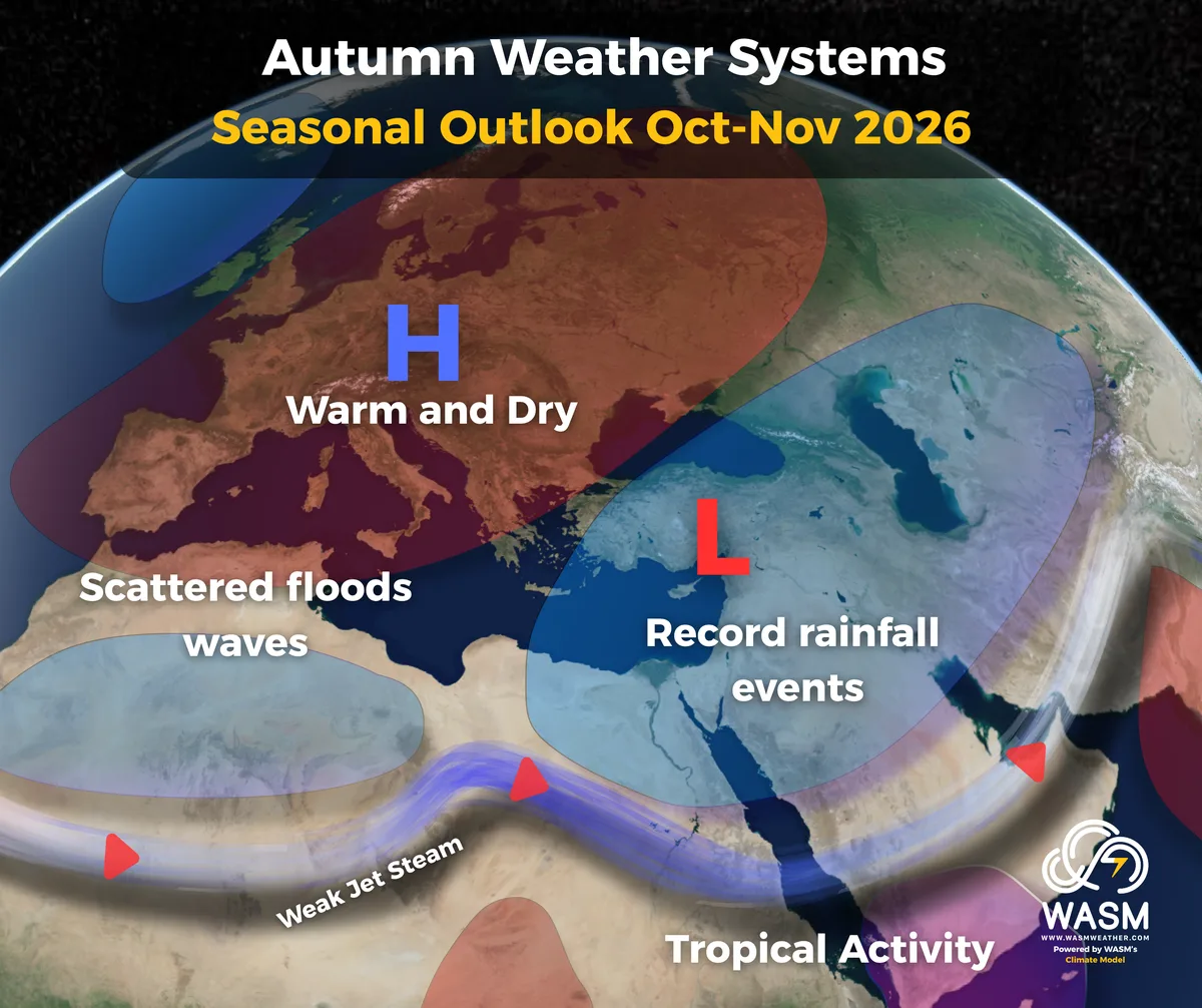
WASM – The WASM Regional Center issues the main seasonal update for the 2026–2027 season across the Arab region and Europe, based on data from our enhanced climate model, which has recorded high accuracy in recent seasons, exceeding 88% in seasonal forecasts since 2018, including the detection of exceptional events.
It is expected that the upcoming rainy season will be record-breaking across many parts of the Middle East, especially the Arabian Peninsula and the Levant, due to an unusual atmospheric circulation pattern driven by climate change, climatic factors occurring in the North Atlantic, and the strong El Niño phenomenon.
General Overview
The rainy season is expected to be extremely wet across two main periods:
- The first period during autumn, especially October and November and into the first half of December (10–11–12).
- The second period from late December through February (late 12 to month 2).
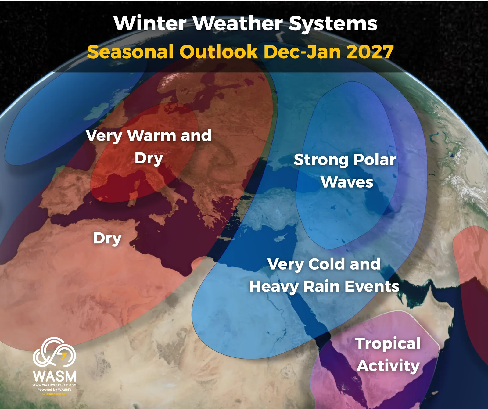
The autumn period will feature intense rainfall across wide areas of the Arabian Peninsula, the Levant, and even the Maghreb. The second period will be characterized by very cold rain events, high chances of snowfall in northern Arabia and the Levant, elevated flood risk in eastern and southern Arabia, and long dry spells in the Maghreb.
Europe will experience unusually long and intense warm and dry spells during winter, while the far western and northern parts will be affected by Atlantic westerlies. Eastern Europe will be exposed to very strong polar outbreaks.
Arabian Peninsula
The Arabian Peninsula is expected to experience an intense and unusual rainy season across two phases:
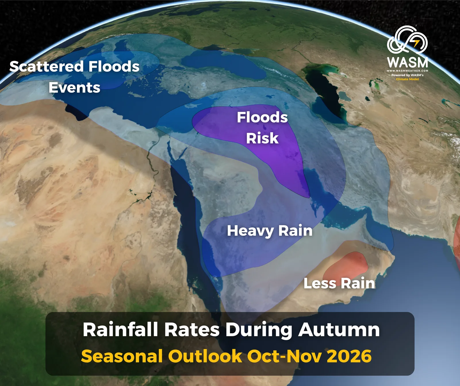
First phase (Autumn – October & November): Concentrated over northern, central, and eastern Saudi Arabia, Kuwait, Iraq, Qatar, Bahrain, and the Red Sea region.
Rainfall begins in early October over northern Saudi Arabia, intensifies from mid-October, and becomes strong and frequent throughout November and into mid-December, covering wide regions.
Rain extends across most of Saudi Arabia during autumn, with strong impacts on northeastern Saudi Arabia, Hafar Al-Batin, central regions, Al-Qassim, Hail, and northern areas such as Al-Jawf and the Northern Borders. Red Sea coastal areas and Makkah will also be affected. Toward late autumn, strong rainfall shifts toward eastern Riyadh, Qatar, Bahrain, and the UAE, continuing intermittently elsewhere.
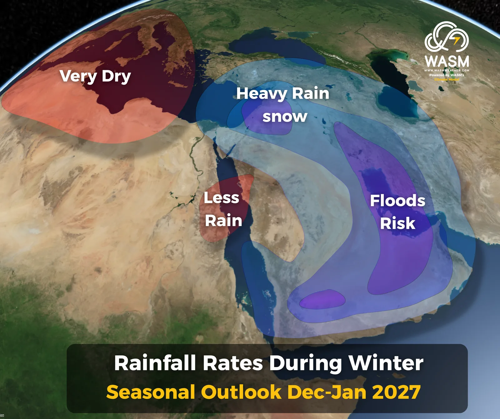
Second phase (Winter – colder period): Centered over eastern and southern Saudi Arabia, the UAE, Oman, extending toward central, northeastern, and northern Saudi Arabia and Iraq. This phase coincides with cold waves during January and February, with high chances of snowfall in northern Saudi Arabia and parts of Iraq due to the intrusion of very cold air masses from Eastern Europe.
Overall, the rainy season will be marked by frequent, widespread heavy rainfall, especially during autumn, supported by active Mediterranean lows and abundant moisture across atmospheric layers.
Levant
The Levant is expected to experience a very wet and, in some areas, record-breaking rainy season, varying in intensity from period to period.
First phase (Autumn – mid October to mid December): Characterized by frequent and intense rainfall events, raising flood risk across Jordan, Syria, Palestine, and Lebanon.
Autumn rainfall will feature active Mediterranean frontal systems combined at times with deep Red Sea trough extensions, alongside colder-than-normal periods due to heavy rainfall. The strongest and most frequent events are expected in November.
The upcoming autumn is expected to record large and, in some areas, record-breaking rainfall totals due to repeated rain events.
Second phase (Winter – December–January–February): Mediterranean lows become significantly stronger than usual, with colder conditions, heavy rainfall, and increased chances of snowfall, especially toward the end of the period.
Winter rainfall will be more concentrated over southern parts of the Levant due to a sharp jet stream dip over the southeastern Mediterranean.
Iraq & Egypt
Iraq is expected to experience an extremely wet season across two phases:
- Autumn: Heavy rainfall across most regions, especially eastern and southeastern Iraq.
- Winter (Dec–Jan–Feb): Very cold conditions with frequent rain events and high chances of snowfall in northern Iraq and parts of the west.
Northern and eastern Egypt are expected to experience heavy rainfall during autumn, but weaker rainfall during winter due to Mediterranean lows shifting toward the far eastern Mediterranean.
Maghreb Region
The western Maghreb is expected to experience a generally dry rainy season due to the influence of a strong high-pressure system, especially during winter.
Flood waves may occur during autumn but will be intermittent and less widespread due to the persistent Azores High.
Rainfall weakens significantly during December–January–February, with possible long warm and dry spells. This does not imply a complete absence of rainfall, but totals will be clearly below normal.
Atmospheric Circulation Overview
Atmospheric circulation is expected to be highly unusual due to abnormal behavior of upper-level jet streams driven by climate change and extreme climatic factors.
Strong changes in the North Atlantic, including cooling of its northern sector, have caused an abnormal weakening and sharp meandering of the polar jet stream. This leads to prolonged dominance of the Azores High over much of Europe, weakening Atlantic storms and forcing westerlies toward far northern Europe or rapidly toward southern Europe and the eastern Mediterranean. This explains the recent European heatwaves and the mild, short summer in the Levant.
Simultaneously, the strong El Niño has significantly weakened the subtropical jet stream, creating a nontraditional atmospheric pattern over the Middle East and Arabian Peninsula, combined with strong tropical moisture transport from the Arabian Sea enhanced by warm waters in the western Indian Ocean and Arabian Sea. This rare combination of extreme climatic factors occurring simultaneously is highly unusual.
The sharp dip of the polar jet stream combined with the subtropical jet stream dip will shift baroclinic and frontal activity toward the southeastern Mediterranean and northern Saudi Arabia, resulting in intense rainfall events across Arabia, the Levant, Iraq, and northern Egypt.
A strong high-pressure system is expected to dominate most of Europe during much of the upcoming rainy season due to this unusual jet stream behavior.
El Niño is not the only major driver; the North Atlantic’s influence on Europe and the Arab region is more significant according to our model’s flexible analog-based calibration.
Clear temperature changes have also been observed in the North Pacific, creating a pattern similar to the Atlantic and reinforcing it, especially with rising temperatures along the coasts of California and western Canada and cooling in the northeastern Pacific.
The continued influx of cold water into the tropical Atlantic may signal major changes in North Atlantic temperatures, increasing the likelihood of altered jet stream behavior.
Seasonal Outlook Accuracy
The seasonal Outlook relies on our climate model, which uses flexible statistical analog periods. Despite its strong performance with 88% accuracy in previous seasonal forecasts, this does not guarantee identical accuracy for the upcoming season. Accuracy varies by region due to rapid atmospheric changes. Daily weather forecasts should be monitored continuously for higher precision.
Recommended Preparations by WASM Regional Center
Due to expected heavy rainfall across much of the Middle East, infrastructure, dams, and water-harvesting systems must be reinforced to reduce losses. Continuous monitoring of official warnings is essential.
The WASM Regional Center will monitor rainfall events continuously and issue alerts for each region through our new application, now available on the Apple Store and Google Play, based on our W.DMM technology developed to enhance weather forecast accuracy in the Arab region.
More updates will be released in the coming days as monthly and regional bulletins are activated, based on data from our enhanced climate model.